Property Record
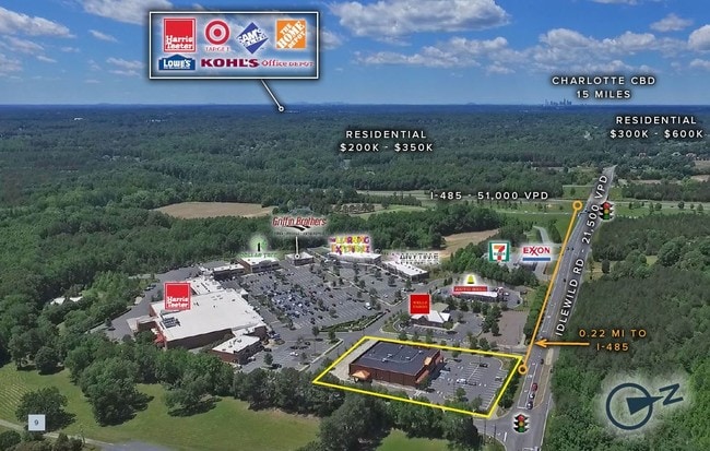
15090 Idlewild Rd, Matthews, NC 28104
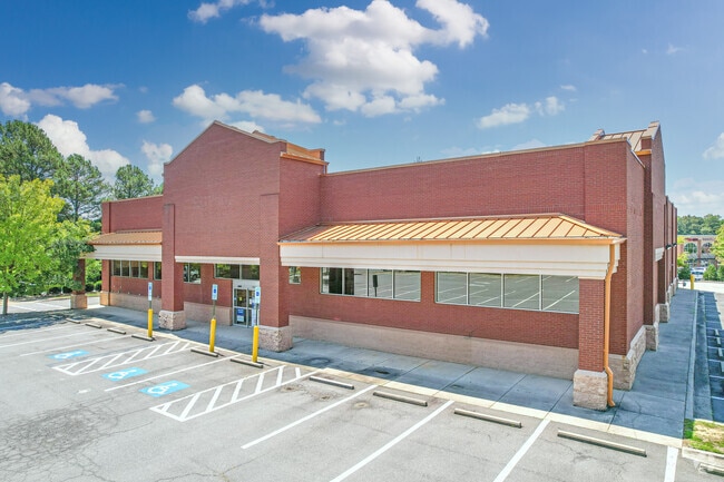

Property Detail
15090 Idlewild Rd
07-075-258
OUTPARCEL #C-CRESCENT RESOURCES OPCH882
Drugstorepharmacycvswalgreens
Union
GR STALLIN
North Carolina
B and X Area of moderate flood hazard, usually the area between the limits of the 100-year and 500-year floods.
1.60 AC
2025
Union County
2025
Charlotte
020319
Charlotte-Concord-Gastonia, NC-SC
14,490 SF
NEARBY LISTINGS FOR SALE OR LEASE
DEMOGRAPHICS near 15090 Idlewild Rd
1 mile
3 mile
5 mile
2025 Total Population
4,414
36,700
112,372
2030 Population
4,732
39,882
122,333
Pop Growth 2025-2030
+ 7.20%
+ 8.67%
+ 8.86%
Average Age
41
42
41
2025 Total Households
1,516
13,416
42,061
HH Growth 2025-2030
+ 7.32%
+ 8.83%
+ 9.03%
Median Household Inc
$115,624
$105,855
$98,748
Avg Household Size
2.90
2.70
2.60
2025 Avg HH Vehicles
2.00
2.00
2.00
Median Home Value
$468,496
$426,514
$425,623
Median Year Built
1999
1997
1998
Nearby Places
Map Layers
Map Styles
 Street
 Aerial
Layers
 Traffic
 Biking
Places
Listings with unknown addresses are not visible on the map
- Restaurants
- Banks
- Shops
- Fitness
- Groceries
PUBLIC TRANSPORTATION
AIRPORT
Concord-Padgett Regional
Drive
Walk
Distance
Concord-Padgett Regional
29 min
22.7 mi
Charlotte/Douglas International
Drive
Walk
Distance
Charlotte/Douglas International
37 min
22.8 mi
SALE & LEASE HISTORY
LISTING DATE
SALE/LEASE

Sep 01, 2021
For Lease
Mar 04, 2019
For Lease
Jun 20, 2017
For Sale
Jun 19, 2018
For Lease
Aug 11, 2017
For Sale
Nearby Properties
Address
Land Use
TOTAL SIZE
Lot Size
Zoning
Address
Land Use
TOTAL SIZE
Lot Size
Zoning
262,337 SF
7.35 AC
Address
Land Use
TOTAL SIZE
Lot Size
Zoning
282,922 SF
47.76 AC
R4
Address
Land Use
TOTAL SIZE
Lot Size
Zoning
269,164 SF
18.57 AC
Address
Land Use
TOTAL SIZE
Lot Size
Zoning
258,053 SF
14.99 AC
Address
Land Use
TOTAL SIZE
Lot Size
Zoning
281,872 SF
37.85 AC
R12CD
Address
Land Use
TOTAL SIZE
Lot Size
Zoning
274,215 SF
17.50 AC
O9CD
Address
Land Use
TOTAL SIZE
Lot Size
Zoning
254,369 SF
43.75 AC
B1SCD
Address
Land Use
TOTAL SIZE
Lot Size
Zoning
104,880 SF
10.01 AC
R-12
Address
Land Use
TOTAL SIZE
Lot Size
Zoning
174,834 SF
2.51 AC
Address
Land Use
TOTAL SIZE
Lot Size
Zoning
12.30 AC
SF-1 INDIA
Address
Land Use
TOTAL SIZE
Lot Size
Zoning
2,062 SF
105.82 AC
B-1SCD
Address
Land Use
TOTAL SIZE
Lot Size
Zoning
158,321 SF
9.20 AC
Address
Land Use
TOTAL SIZE
Lot Size
Zoning
75,923 SF
7.29 AC
SF-1 INDIA
Address
Land Use
TOTAL SIZE
Lot Size
Zoning
93,040 SF
16.57 AC
GR STALLIN
Address
Land Use
TOTAL SIZE
Lot Size
Zoning
15,539 SF
50.79 AC
Address
Land Use
TOTAL SIZE
Lot Size
Zoning
96,456 SF
34.88 AC
R-20 STALL
Address
Land Use
TOTAL SIZE
Lot Size
Zoning
86,960 SF
14.13 AC
SF-1 INDIA
Address
Land Use
TOTAL SIZE
Lot Size
Zoning
88,318 SF
12.10 AC
O(CD)
Address
Land Use
TOTAL SIZE
Lot Size
Zoning
74,111 SF
8.14 AC
R12CD
Address
Land Use
TOTAL SIZE
Lot Size
Zoning
139,072 SF
13.02 AC
B-1SCD
Address
Land Use
TOTAL SIZE
Lot Size
Zoning
130,670 SF
12.72 AC
B1SCD
Address
Land Use
TOTAL SIZE
Lot Size
Zoning
77,438 SF
4.26 AC
BD
Address
Land Use
TOTAL SIZE
Lot Size
Zoning
36,480 SF
12.21 AC
NRD STALLI
Address
Land Use
TOTAL SIZE
Lot Size
Zoning
61,625 SF
3.22 AC
B-3(CD)
Address
Land Use
TOTAL SIZE
Lot Size
Zoning
244,087 SF
15.81 AC
CZ STALLIN
Address
Land Use
TOTAL SIZE
Lot Size
Zoning
52,747 SF
8.05 AC
GR STALLIN
Address
Land Use
TOTAL SIZE
Lot Size
Zoning
47,861 SF
18.65 AC
R-15
Address
Land Use
TOTAL SIZE
Lot Size
Zoning
75,951 SF
5.82 AC
LI INDIAN
Address
Land Use
TOTAL SIZE
Lot Size
Zoning
36,731 SF
7.01 AC
GBD INDIAN
Address
Land Use
TOTAL SIZE
Lot Size
Zoning
63,948 SF
5.78 AC
B-1SCD
The World's #1 Commercial Real Estate Marketplace
Connect with us
© 2026 CoStar Group
The information above has been obtained from sources believed reliable. While we do not doubt its accuracy we have not verified it and make no guarantee, warranty or representation about it. It is your responsibility to independently confirm its accuracy and completeness. Any projections, opinions, assumptions, or estimates used are for example only and do not represent the current or future performance of the property. The value of this transaction to you depends on tax and other factors which should be evaluated by your tax, financial, and legal advisors. You and your advisors should conduct a careful, independent investigation of the property to determine to your satisfaction the suitability of the property for your needs.