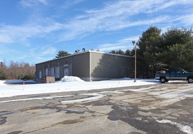
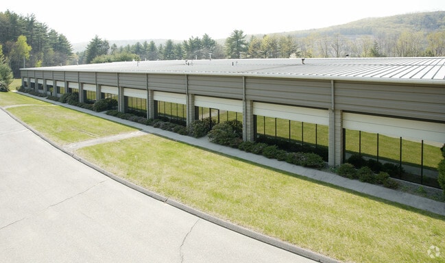
Property Record
151 Ella Grasso Ave, Torrington, CT 06790

Property Detail
151 Ella Grasso Ave
TORR-000242-000004-000001
Nw Hills
Multipleuses
Connecticut
IP
1
2025
6.53 AC
2025
Rt 8/Winsted
310601
Hartford
30,260 SF
Torrington, CT
NEARBY LISTINGS FOR SALE OR LEASE
DEMOGRAPHICS near 151 Ella Grasso Ave
1 mile
3 mile
5 mile
2025 Total Population
1,517
8,532
35,033
2030 Population
1,537
8,731
35,307
Pop Growth 2025-2030
+ 1.32%
+ 2.33%
+ 0.78%
Average Age
42
45
45
2025 Total Households
551
3,471
15,180
HH Growth 2025-2030
+ 1.27%
+ 2.39%
+ 0.80%
Median Household Inc
$97,862
$94,045
$78,993
Avg Household Size
2.60
2.40
2.20
2025 Avg HH Vehicles
2.00
2.00
2.00
Median Home Value
$256,849
$277,272
$248,230
Median Year Built
1989
1979
1965
Nearby Places
Map Layers
Map Styles
 Street
 Aerial
Transit
 Traffic
 Biking
Places
Listings with unknown addresses are not visible on the map
- Restaurants
- Banks
- Shops
- Fitness
- Groceries
PUBLIC TRANSPORTATION
AIRPORT
Bradley International
Drive
Walk
Distance
Bradley International
57 min
27.1 mi
SALE & LEASE HISTORY
LISTING DATE
SALE/LEASE

Oct 11, 2024
For Lease
Nearby Properties
Address
Land Use
TOTAL SIZE
Lot Size
Zoning
Address
Land Use
TOTAL SIZE
Lot Size
Zoning
171,271 SF
26 AC
R-WP
Address
Land Use
TOTAL SIZE
Lot Size
Zoning
13.79 AC
CX
Address
Land Use
TOTAL SIZE
Lot Size
Zoning
200,000 SF
32.82 AC
IP
Address
Land Use
TOTAL SIZE
Lot Size
Zoning
30.48 AC
IP
Address
Land Use
TOTAL SIZE
Lot Size
Zoning
132,962 SF
7.30 AC
IP
Address
Land Use
TOTAL SIZE
Lot Size
Zoning
53,252 SF
32.19 AC
RU-1
Address
Land Use
TOTAL SIZE
Lot Size
Zoning
93,750 SF
9.19 AC
IP
Address
Land Use
TOTAL SIZE
Lot Size
Zoning
129,282 SF
27.60 AC
I
Address
Land Use
TOTAL SIZE
Lot Size
Zoning
90,039 SF
6.98 AC
IP
Address
Land Use
TOTAL SIZE
Lot Size
Zoning
193.61 AC
I
Address
Land Use
TOTAL SIZE
Lot Size
Zoning
10.69 AC
IP
Address
Land Use
TOTAL SIZE
Lot Size
Zoning
338.20 AC
R2
Address
Land Use
TOTAL SIZE
Lot Size
Zoning
68,056 SF
16.97 AC
IP
Address
Land Use
TOTAL SIZE
Lot Size
Zoning
77,420 SF
8.70 AC
IP
Address
Land Use
TOTAL SIZE
Lot Size
Zoning
14.46 AC
R-1
Address
Land Use
TOTAL SIZE
Lot Size
Zoning
10.25 AC
IP
Address
Land Use
TOTAL SIZE
Lot Size
Zoning
50,096 SF
9.66 AC
IP
Address
Land Use
TOTAL SIZE
Lot Size
Zoning
161.20 AC
R60
Address
Land Use
TOTAL SIZE
Lot Size
Zoning
14,496 SF
4.50 AC
LB
Address
Land Use
TOTAL SIZE
Lot Size
Zoning
7.20 AC
I
Address
Land Use
TOTAL SIZE
Lot Size
Zoning
48.54 AC
I
Address
Land Use
TOTAL SIZE
Lot Size
Zoning
63,394 SF
6.64 AC
IP
Address
Land Use
TOTAL SIZE
Lot Size
Zoning
53,000 SF
13.36 AC
IP
Address
Land Use
TOTAL SIZE
Lot Size
Zoning
27,840 SF
4.29 AC
LB
Address
Land Use
TOTAL SIZE
Lot Size
Zoning
55,700 SF
8.26 AC
IP
Address
Land Use
TOTAL SIZE
Lot Size
Zoning
459 SF
54.43 AC
R40
Address
Land Use
TOTAL SIZE
Lot Size
Zoning
4,862 SF
13.24 AC
IP
Address
Land Use
TOTAL SIZE
Lot Size
Zoning
37,800 SF
5.10 AC
IP
Address
Land Use
TOTAL SIZE
Lot Size
Zoning
27,940 SF
8.01 AC
IB-1
Address
Land Use
TOTAL SIZE
Lot Size
Zoning
2,945 SF
0.45 AC
HLD
The World's #1 Commercial Real Estate Marketplace
Connect with us
© 2026 CoStar Group
The information above has been obtained from sources believed reliable. While we do not doubt its accuracy we have not verified it and make no guarantee, warranty or representation about it. It is your responsibility to independently confirm its accuracy and completeness. Any projections, opinions, assumptions, or estimates used are for example only and do not represent the current or future performance of the property. The value of this transaction to you depends on tax and other factors which should be evaluated by your tax, financial, and legal advisors. You and your advisors should conduct a careful, independent investigation of the property to determine to your satisfaction the suitability of the property for your needs.