Property Record
151 Jacolyn Dr Nw, Cedar Rapids, IA 52405

NEARBY LISTINGS FOR SALE OR LEASE
Property Detail
151 Jacolyn Dr Nw
13253-26004-00000
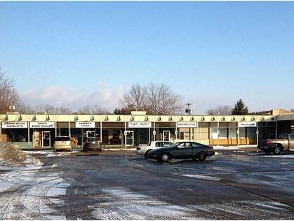
Cedar Hill
Regionalshoppingcenterormallwithanchorstore
CEDAR HILLS UNIT ONE (LESS S 200.4 MEAS ON E LN) & (LESS S 144 N 254.4 W 180) & (LESS N 110.4) TRACT A STR/LB
X
Linn
19113C0405F
Iowa
2024
2.03 AC
2025
Cedar Hills
001004
Other Market Areas
22,050 SF
Cedar Rapids, IA
DEMOGRAPHICS near 151 Jacolyn Dr Nw
1 Mile
3 Mile
5 Mile
2024 Total Population
12,405
52,157
98,847
2029 Population
12,431
52,054
98,771
Pop Growth 2024-2029
+ 0.21%
(0.20%)
(0.08%)
Average Age
39
40
40
2024 Total Households
5,407
21,853
41,336
HH Growth 2024-2029
+ 0.33%
(0.22%)
(0.06%)
Median Household Inc
$45,360
$61,509
$62,246
Avg Household Size
2.20
2.30
2.20
2024 Avg HH Vehicles
2.00
2.00
2.00
Median Home Value
$154,789
$168,566
$170,236
Median Year Built
1973
1977
1972
Nearby Places
Map Layers
Map Styles
 Street
 Aerial
- Restaurants
- Banks
- Shops
- Fitness
- Groceries
PUBLIC TRANSPORTATION
AIRPORT
The Eastern Iowa
DRIVE
WALK
Distance
The Eastern Iowa
14 min
6.9 mi
SALE & LEASE HISTORY
LISTING DATE
SALE/LEASE

Mar 26, 2018
For Lease
Nearby Properties
Address
Land Use
TOTAL SIZE
Lot Size
Zoning
Address
Land Use
TOTAL SIZE
Lot Size
Zoning
308,309 SF
17.97 AC
Address
Land Use
TOTAL SIZE
Lot Size
Zoning
427,700 SF
12.67 AC
Address
Land Use
TOTAL SIZE
Lot Size
Zoning
68,553 SF
7.70 AC
Address
Land Use
TOTAL SIZE
Lot Size
Zoning
42,449 SF
4.70 AC
Address
Land Use
TOTAL SIZE
Lot Size
Zoning
1,049,268 SF
79.35 AC
Address
Land Use
TOTAL SIZE
Lot Size
Zoning
59,467 SF
8.39 AC
Address
Land Use
TOTAL SIZE
Lot Size
Zoning
110,583 SF
15.56 AC
Address
Land Use
TOTAL SIZE
Lot Size
Zoning
66,922 SF
4.90 AC
Address
Land Use
TOTAL SIZE
Lot Size
Zoning
416,830 SF
18.06 AC
Address
Land Use
TOTAL SIZE
Lot Size
Zoning
88,849 SF
18.63 AC
Address
Land Use
TOTAL SIZE
Lot Size
Zoning
212,316 SF
23.89 AC
Address
Land Use
TOTAL SIZE
Lot Size
Zoning
205,013 SF
16.44 AC
Address
Land Use
TOTAL SIZE
Lot Size
Zoning
189,188 SF
19.44 AC
Address
Land Use
TOTAL SIZE
Lot Size
Zoning
39,271 SF
0.66 AC
Address
Land Use
TOTAL SIZE
Lot Size
Zoning
175,600 SF
15.91 AC
Address
Land Use
TOTAL SIZE
Lot Size
Zoning
44,754 SF
6 AC
Address
Land Use
TOTAL SIZE
Lot Size
Zoning
68,384 SF
17.90 AC
Address
Land Use
TOTAL SIZE
Lot Size
Zoning
70,918 SF
6.70 AC
Address
Land Use
TOTAL SIZE
Lot Size
Zoning
58,289 SF
4 AC
Address
Land Use
TOTAL SIZE
Lot Size
Zoning
24,178 SF
0.52 AC
Address
Land Use
TOTAL SIZE
Lot Size
Zoning
76,762 SF
6.46 AC
Address
Land Use
TOTAL SIZE
Lot Size
Zoning
49,896 SF
3.80 AC
Address
Land Use
TOTAL SIZE
Lot Size
Zoning
39,060 SF
10.69 AC
Address
Land Use
TOTAL SIZE
Lot Size
Zoning
274,433 SF
17.68 AC
Address
Land Use
TOTAL SIZE
Lot Size
Zoning
14,839 SF
1.82 AC
Address
Land Use
TOTAL SIZE
Lot Size
Zoning
232,750 SF
9.65 AC
Address
Land Use
TOTAL SIZE
Lot Size
Zoning
37,889 SF
7.54 AC
Address
Land Use
TOTAL SIZE
Lot Size
Zoning
39,679 SF
28.85 AC
Address
Land Use
TOTAL SIZE
Lot Size
Zoning
39,280 SF
9.91 AC
Address
Land Use
TOTAL SIZE
Lot Size
Zoning
15,196 SF
1.79 AC
The World's #1 Commercial Real Estate Marketplace
Connect with us
© 2025 CoStar Group
The information above has been obtained from sources believed reliable. While we do not doubt its accuracy we have not verified it and make no guarantee, warranty or representation about it. It is your responsibility to independently confirm its accuracy and completeness. Any projections, opinions, assumptions, or estimates used are for example only and do not represent the current or future performance of the property. The value of this transaction to you depends on tax and other factors which should be evaluated by your tax, financial, and legal advisors. You and your advisors should conduct a careful, independent investigation of the property to determine to your satisfaction the suitability of the property for your needs.