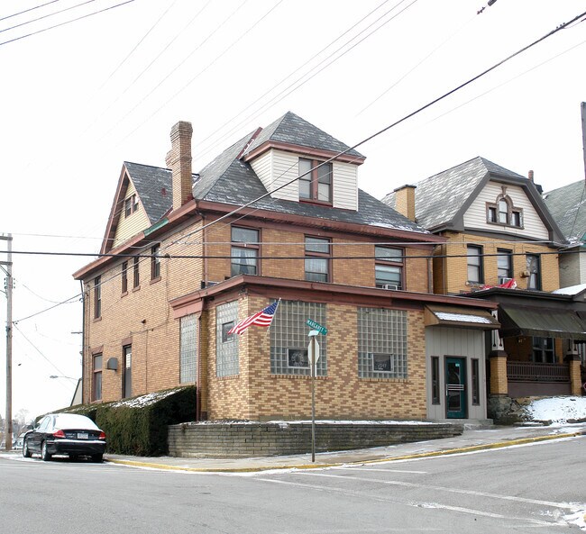
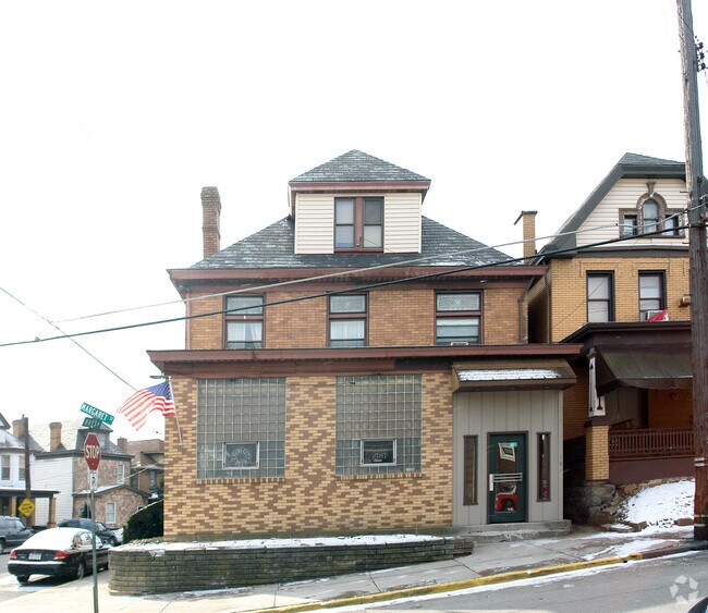
Property Record
151 Margaret St, Pittsburgh, PA 15210
NEARBY LISTINGS FOR SALE OR LEASE
Property Detail
151 Margaret St
Pittsburgh, PA
Penn Manor Plan
0033-G-00193-0000-00
PENN MANOR PLAN 23 LOT 33.35X100X21.47 RR MARGA RET ST COR HAYS AV 2 1/2 STY BRK & ALUM VEN TAP RM & APTS 151
Retailwithmorethanonenonretailuse
Allegheny
X
Pennsylvania
42003C0361H
193
2024
0.06 AC
2025
South Pittsburgh/Rte 51
481000
Pittsburgh
DEMOGRAPHICS near 151 Margaret St
1 Mile
3 Mile
5 Mile
2024 Total Population
18,982
147,302
389,383
2029 Population
18,912
145,416
383,449
Pop Growth 2024-2029
(0.37%)
(1.28%)
(1.52%)
Average Age
39
39
40
2024 Total Households
8,085
67,197
177,300
HH Growth 2024-2029
(0.40%)
(1.28%)
(1.57%)
Median Household Inc
$40,052
$55,552
$63,456
Avg Household Size
2.20
2.00
2.00
2024 Avg HH Vehicles
1.00
1.00
1.00
Median Home Value
$73,502
$149,797
$185,255
Median Year Built
1947
1950
1951
Nearby Places
Map Layers
Map Styles
 Street
 Aerial
- Restaurants
- Banks
- Shops
- Fitness
- Groceries
PUBLIC TRANSPORTATION
TRANSIT/SUBWAY
Bon Air (47L Library - Port Authority of Allegheny County Light Rail (The "T"), 47S South Hills Village - Port Authority of Allegheny County Light Rail (The "T"))
DRIVE
WALK
Distance
Bon Air (47L Library - Port Authority of Allegheny County Light Rail (The "T"), 47S South Hills Village - Port Authority of Allegheny County Light Rail (The "T"))
4 min
20 min
1.0 mi
COMMUTER RAIL
Pittsburgh Amtrak Station (Capitol Limited - Amtrak, Pennsylvanian - Amtrak)
DRIVE
WALK
Distance
Pittsburgh Amtrak Station (Capitol Limited - Amtrak, Pennsylvanian - Amtrak)
7 min
3.1 mi
AIRPORT
Pittsburgh International
DRIVE
WALK
Distance
Pittsburgh International
31 min
19.5 mi
Freight Ports
Port of Baltimore
DRIVE
WALK
Distance
Port of Baltimore
295 min
248.6 mi
Nearby Properties
Address
Land Use
TOTAL SIZE
Lot Size
Zoning
Address
Land Use
TOTAL SIZE
Lot Size
Zoning
10.41 AC
Address
Land Use
TOTAL SIZE
Lot Size
Zoning
Address
Land Use
TOTAL SIZE
Lot Size
Zoning
14.70 AC
Address
Land Use
TOTAL SIZE
Lot Size
Zoning
Address
Land Use
TOTAL SIZE
Lot Size
Zoning
3.86 AC
Address
Land Use
TOTAL SIZE
Lot Size
Zoning
10.14 AC
Address
Land Use
TOTAL SIZE
Lot Size
Zoning
13.53 AC
Address
Land Use
TOTAL SIZE
Lot Size
Zoning
3.35 AC
Address
Land Use
TOTAL SIZE
Lot Size
Zoning
5.11 AC
Address
Land Use
TOTAL SIZE
Lot Size
Zoning
13.85 AC
Address
Land Use
TOTAL SIZE
Lot Size
Zoning
3.91 AC
Address
Land Use
TOTAL SIZE
Lot Size
Zoning
2.68 AC
Address
Land Use
TOTAL SIZE
Lot Size
Zoning
4.05 AC
Address
Land Use
TOTAL SIZE
Lot Size
Zoning
12.80 AC
Address
Land Use
TOTAL SIZE
Lot Size
Zoning
0.92 AC
Address
Land Use
TOTAL SIZE
Lot Size
Zoning
3.78 AC
Address
Land Use
TOTAL SIZE
Lot Size
Zoning
2.46 AC
Address
Land Use
TOTAL SIZE
Lot Size
Zoning
2.52 AC
Address
Land Use
TOTAL SIZE
Lot Size
Zoning
1.20 AC
Address
Land Use
TOTAL SIZE
Lot Size
Zoning
0.85 AC
Address
Land Use
TOTAL SIZE
Lot Size
Zoning
2.31 AC
Address
Land Use
TOTAL SIZE
Lot Size
Zoning
1.43 AC
Address
Land Use
TOTAL SIZE
Lot Size
Zoning
Address
Land Use
TOTAL SIZE
Lot Size
Zoning
Address
Land Use
TOTAL SIZE
Lot Size
Zoning
Address
Land Use
TOTAL SIZE
Lot Size
Zoning
0.19 AC
Address
Land Use
TOTAL SIZE
Lot Size
Zoning
Address
Land Use
TOTAL SIZE
Lot Size
Zoning
1.82 AC
Address
Land Use
TOTAL SIZE
Lot Size
Zoning
6.55 AC
Address
Land Use
TOTAL SIZE
Lot Size
Zoning
1.10 AC
The World's #1 Commercial Real Estate Marketplace
Connect with us
© 2025 CoStar Group
The information above has been obtained from sources believed reliable. While we do not doubt its accuracy we have not verified it and make no guarantee, warranty or representation about it. It is your responsibility to independently confirm its accuracy and completeness. Any projections, opinions, assumptions, or estimates used are for example only and do not represent the current or future performance of the property. The value of this transaction to you depends on tax and other factors which should be evaluated by your tax, financial, and legal advisors. You and your advisors should conduct a careful, independent investigation of the property to determine to your satisfaction the suitability of the property for your needs.