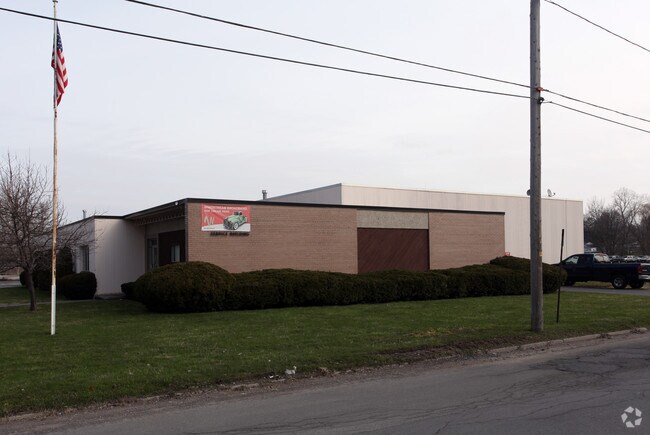
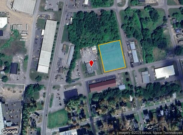
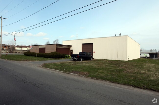
Property Record
151 N 3Rd St, Fulton, NY 13069
NEARBY LISTINGS FOR SALE OR LEASE
Property Detail
151 N 3Rd St
350400-236-048-0006-015-000-0000
Oswego
Telephonefacility
New York
AO
13.000
36075C0458G
1.18 AC
2024
Oswego County
2024
Syracuse
021101
Syracuse, NY
9,790 SF
DEMOGRAPHICS near 151 N 3Rd St
1 mile
3 mile
5 mile
2024 Total Population
7,537
14,916
20,607
2029 Population
7,492
14,833
20,476
Pop Growth 2024-2029
(0.60%)
(0.56%)
(0.64%)
Average Age
39
40
41
2024 Total Households
3,184
6,179
8,383
HH Growth 2024-2029
(0.60%)
(0.57%)
(0.64%)
Median Household Inc
$43,256
$50,969
$53,765
Avg Household Size
2.30
2.30
2.40
2024 Avg HH Vehicles
1.00
2.00
2.00
Median Home Value
$64,504
$83,356
$91,772
Median Year Built
1948
1955
1961
Nearby Places
Map Layers
Map Styles
 Street
 Aerial
Transit
 Traffic
 Biking
Places
Listings with unknown addresses are not visible on the map
- Restaurants
- Banks
- Shops
- Fitness
- Groceries
PUBLIC TRANSPORTATION
AIRPORT
Syracuse Hancock International
Drive
Walk
Distance
Syracuse Hancock International
33 min
25.2 mi
Nearby Properties
Address
Land Use
TOTAL SIZE
Lot Size
Zoning
Address
Land Use
TOTAL SIZE
Lot Size
Zoning
188,491 SF
33.66 AC
Address
Land Use
TOTAL SIZE
Lot Size
Zoning
127,601 SF
22.08 AC
C2
Address
Land Use
TOTAL SIZE
Lot Size
Zoning
178,780 SF
42.86 AC
R1
Address
Land Use
TOTAL SIZE
Lot Size
Zoning
193,000 SF
96.55 AC
I-1
Address
Land Use
TOTAL SIZE
Lot Size
Zoning
8,096 SF
13.15 AC
R1
Address
Land Use
TOTAL SIZE
Lot Size
Zoning
10.57 AC
R-1
Address
Land Use
TOTAL SIZE
Lot Size
Zoning
85,869 SF
59.55 AC
Address
Land Use
TOTAL SIZE
Lot Size
Zoning
33,416 SF
2.21 AC
R2
Address
Land Use
TOTAL SIZE
Lot Size
Zoning
308,133 SF
7.60 AC
M1
Address
Land Use
TOTAL SIZE
Lot Size
Zoning
6,656 SF
9.94 AC
R3
Address
Land Use
TOTAL SIZE
Lot Size
Zoning
50,818 SF
5 AC
C2
Address
Land Use
TOTAL SIZE
Lot Size
Zoning
98,307 SF
26.58 AC
R1
Address
Land Use
TOTAL SIZE
Lot Size
Zoning
78,713 SF
8.30 AC
R1
Address
Land Use
TOTAL SIZE
Lot Size
Zoning
99,592 SF
0.38 AC
C2A
Address
Land Use
TOTAL SIZE
Lot Size
Zoning
793,000 SF
66.99 AC
I-1
Address
Land Use
TOTAL SIZE
Lot Size
Zoning
15,960 SF
6.85 AC
R1A
Address
Land Use
TOTAL SIZE
Lot Size
Zoning
52,776 SF
3.30 AC
R2
Address
Land Use
TOTAL SIZE
Lot Size
Zoning
128,445 SF
5.62 AC
M1
Address
Land Use
TOTAL SIZE
Lot Size
Zoning
2,460 SF
43.70 AC
Address
Land Use
TOTAL SIZE
Lot Size
Zoning
3,432 SF
7.70 AC
R3
Address
Land Use
TOTAL SIZE
Lot Size
Zoning
4.82 AC
I-1
Address
Land Use
TOTAL SIZE
Lot Size
Zoning
51,658 SF
1.43 AC
C2
Address
Land Use
TOTAL SIZE
Lot Size
Zoning
106,531 SF
13.88 AC
M1
Address
Land Use
TOTAL SIZE
Lot Size
Zoning
67,509 SF
8.34 AC
R1
Address
Land Use
TOTAL SIZE
Lot Size
Zoning
128,064 SF
4.50 AC
M1
Address
Land Use
TOTAL SIZE
Lot Size
Zoning
80,240 SF
2.06 AC
C2
Address
Land Use
TOTAL SIZE
Lot Size
Zoning
34,310 SF
2.29 AC
C2A
Address
Land Use
TOTAL SIZE
Lot Size
Zoning
60,480 SF
2.91 AC
C2
Address
Land Use
TOTAL SIZE
Lot Size
Zoning
11,132 SF
19.74 AC
R4
Address
Land Use
TOTAL SIZE
Lot Size
Zoning
51.01 AC
I-1
The World's #1 Commercial Real Estate Marketplace
Connect with us
© 2026 CoStar Group
The information above has been obtained from sources believed reliable. While we do not doubt its accuracy we have not verified it and make no guarantee, warranty or representation about it. It is your responsibility to independently confirm its accuracy and completeness. Any projections, opinions, assumptions, or estimates used are for example only and do not represent the current or future performance of the property. The value of this transaction to you depends on tax and other factors which should be evaluated by your tax, financial, and legal advisors. You and your advisors should conduct a careful, independent investigation of the property to determine to your satisfaction the suitability of the property for your needs.