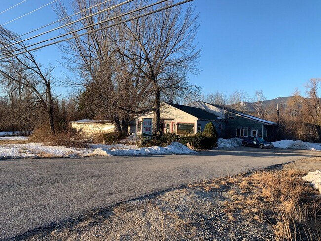
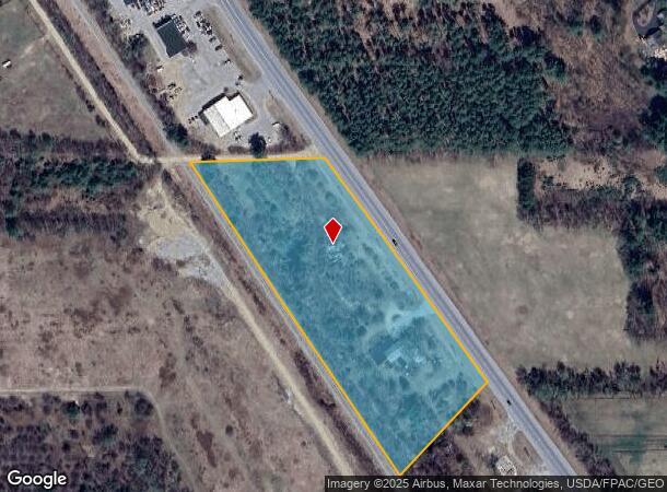
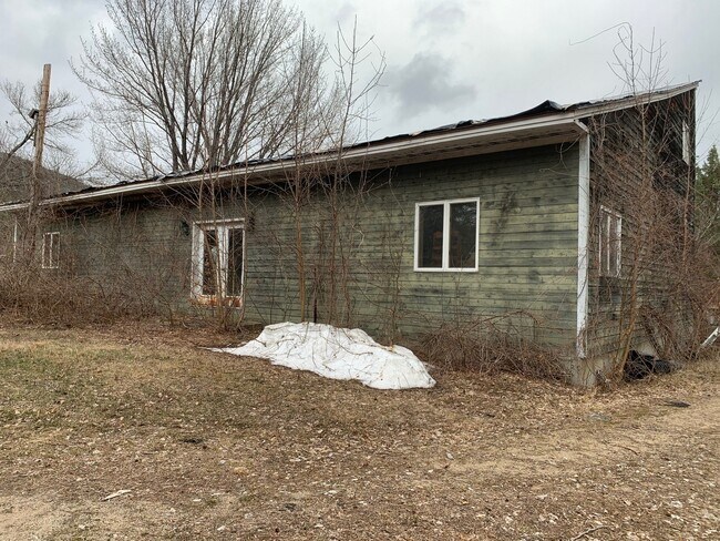
Property Record
151 Nh Route 16 And 302, Intervale, NH 03845
NEARBY LISTINGS FOR SALE OR LEASE
-
-
View all Intervale listings for sale on LoopNet.com
Property Detail
151 Nh Route 16 And 302
Commercialbuilding
Carroll
X
New Hampshire
33003C0185D
73
2024
4.85 AC
2024
Concord/New Hampshire North Area
955102
Other Market Areas
5,716 SF
BART-001016R-T000000L-000073
DEMOGRAPHICS near 151 Nh Route 16 And 302
1 Mile
3 Mile
5 Mile
2024 Total Population
419
3,145
5,401
2029 Population
439
3,317
5,720
Pop Growth 2024-2029
+ 4.77%
+ 5.47%
+ 5.91%
Average Age
50
49
49
2024 Total Households
207
1,537
2,598
HH Growth 2024-2029
+ 4.83%
+ 5.14%
+ 5.54%
Median Household Inc
$57,036
$55,486
$58,762
Avg Household Size
2.00
2.00
2.00
2024 Avg HH Vehicles
2.00
2.00
2.00
Median Home Value
$293,518
$336,600
$352,839
Median Year Built
1981
1981
1980
Nearby Places
Map Layers
Map Styles
 Street
 Aerial
- Restaurants
- Banks
- Shops
- Fitness
- Groceries
SALE & LEASE HISTORY
LISTING DATE
SALE/LEASE

May 27, 2021
For Sale
Nearby Properties
Address
Land Use
TOTAL SIZE
Lot Size
Zoning
Address
Land Use
TOTAL SIZE
Lot Size
Zoning
53.66 AC
HC
Address
Land Use
TOTAL SIZE
Lot Size
Zoning
5,344 SF
102 AC
TOWN C
Address
Land Use
TOTAL SIZE
Lot Size
Zoning
4,119 SF
69.50 AC
TOWN C
Address
Land Use
TOTAL SIZE
Lot Size
Zoning
6 AC
VC
Address
Land Use
TOTAL SIZE
Lot Size
Zoning
46,164 SF
8.10 AC
COMM
Address
Land Use
TOTAL SIZE
Lot Size
Zoning
115 AC
RR
Address
Land Use
TOTAL SIZE
Lot Size
Zoning
10.80 AC
VC
Address
Land Use
TOTAL SIZE
Lot Size
Zoning
Address
Land Use
TOTAL SIZE
Lot Size
Zoning
8.01 AC
VC
Address
Land Use
TOTAL SIZE
Lot Size
Zoning
0.50 AC
VC
Address
Land Use
TOTAL SIZE
Lot Size
Zoning
10,441 SF
5.99 AC
TOWN C
Address
Land Use
TOTAL SIZE
Lot Size
Zoning
17,908 SF
6.50 AC
TOWN R
Address
Land Use
TOTAL SIZE
Lot Size
Zoning
1,500 SF
61.43 AC
RA
Address
Land Use
TOTAL SIZE
Lot Size
Zoning
9.14 AC
HC
Address
Land Use
TOTAL SIZE
Lot Size
Zoning
1,200 SF
4.70 AC
TOWN C
Address
Land Use
TOTAL SIZE
Lot Size
Zoning
1.70 AC
HC
Address
Land Use
TOTAL SIZE
Lot Size
Zoning
3.21 AC
HC
Address
Land Use
TOTAL SIZE
Lot Size
Zoning
0.80 AC
VC
Address
Land Use
TOTAL SIZE
Lot Size
Zoning
1.50 AC
HC
Address
Land Use
TOTAL SIZE
Lot Size
Zoning
688.61 AC
RR
Address
Land Use
TOTAL SIZE
Lot Size
Zoning
1.10 AC
VC
Address
Land Use
TOTAL SIZE
Lot Size
Zoning
0.42 AC
VC
Address
Land Use
TOTAL SIZE
Lot Size
Zoning
3.61 AC
HC
Address
Land Use
TOTAL SIZE
Lot Size
Zoning
672 SF
175.90 AC
TOWN C
Address
Land Use
TOTAL SIZE
Lot Size
Zoning
517.50 AC
TOWN N
Address
Land Use
TOTAL SIZE
Lot Size
Zoning
6,965 SF
7.07 AC
TOWN R
Address
Land Use
TOTAL SIZE
Lot Size
Zoning
1.82 AC
VC
Address
Land Use
TOTAL SIZE
Lot Size
Zoning
1.89 AC
VC
Address
Land Use
TOTAL SIZE
Lot Size
Zoning
8,779 SF
1.72 AC
TOWN R
Address
Land Use
TOTAL SIZE
Lot Size
Zoning
7,560 SF
12 AC
TOWN R
The World's #1 Commercial Real Estate Marketplace
Connect with us
© 2025 CoStar Group
The information above has been obtained from sources believed reliable. While we do not doubt its accuracy we have not verified it and make no guarantee, warranty or representation about it. It is your responsibility to independently confirm its accuracy and completeness. Any projections, opinions, assumptions, or estimates used are for example only and do not represent the current or future performance of the property. The value of this transaction to you depends on tax and other factors which should be evaluated by your tax, financial, and legal advisors. You and your advisors should conduct a careful, independent investigation of the property to determine to your satisfaction the suitability of the property for your needs.