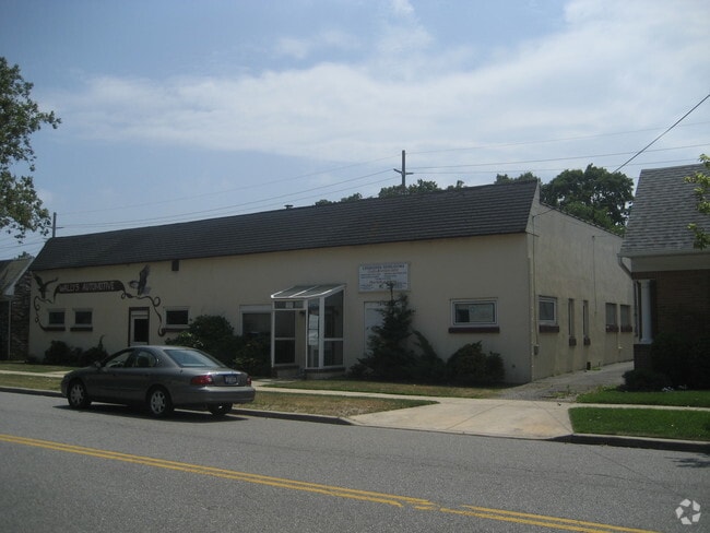
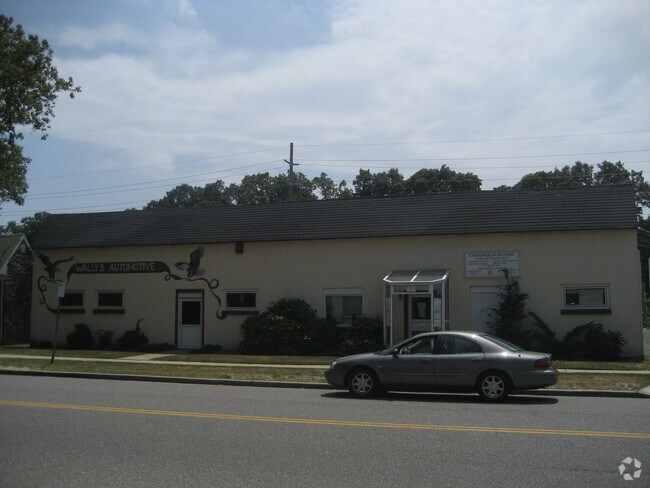
Property Record
151 Orinoco Dr, Brightwaters, NY 11718

Save to a Folder
{{folder.Name}}
{{folder.ListingIds.length}} Properties
{{folder.ListingIds.length}} Property
Create a New Folder
Property Detail
151 Orinoco Dr
Nassau County-Suffolk County, NY
X2203595Y181253 N N00000000
0501-005-00-03-00-059-000
Suffolk
Commercialnec
New York
NULL
300
B and X Area of moderate flood hazard, usually the area between the limits of the 100-year and 500-year floods.
0.24 AC
2024
Southwest Suffolk
2025
Long Island (New York)
147100
NEARBY LISTINGS FOR SALE OR LEASE
DEMOGRAPHICS near 151 Orinoco Dr
1 mile
3 mile
5 mile
2025 Total Population
13,575
94,398
235,369
2030 Population
13,478
92,764
230,559
Pop Growth 2025-2030
(0.71%)
(1.73%)
(2.04%)
Average Age
40
40
40
2025 Total Households
4,790
30,164
72,186
HH Growth 2025-2030
(0.71%)
(1.80%)
(2.14%)
Median Household Inc
$121,484
$127,976
$126,094
Avg Household Size
2.70
3.00
3.10
2025 Avg HH Vehicles
2.00
2.00
2.00
Median Home Value
$635,691
$595,283
$566,465
Median Year Built
1958
1960
1962
Nearby Places
Map Layers
Map Styles
 Street
 Aerial
Layers
 Traffic
 Biking
Places
Listings with unknown addresses are not visible on the map
- Restaurants
- Banks
- Shops
- Fitness
- Groceries
PUBLIC TRANSPORTATION
TRANSIT/SUBWAY
Bay Shore Station (Montauk Branch - Long Island Rail Road)
Drive
Walk
Distance
Bay Shore Station (Montauk Branch - Long Island Rail Road)
3 min
16 min
0.8 mi
COMMUTER RAIL
Bay Shore Station (Montauk Branch - Long Island Rail Road)
Drive
Walk
Distance
Bay Shore Station (Montauk Branch - Long Island Rail Road)
3 min
14 min
0.7 mi
Islip Station (Montauk Branch - Long Island Rail Road)
Drive
Walk
Distance
Islip Station (Montauk Branch - Long Island Rail Road)
7 min
3.5 mi
AIRPORT
Long Island MacArthur
Drive
Walk
Distance
Long Island MacArthur
22 min
12.6 mi
John F Kennedy International
Drive
Walk
Distance
John F Kennedy International
45 min
32.0 mi
LaGuardia
Drive
Walk
Distance
LaGuardia
55 min
39.0 mi
Freight Ports
NY - Red Hook Container Terminal
Drive
Walk
Distance
NY - Red Hook Container Terminal
66 min
43.4 mi
Nearby Properties
Address
Land Use
TOTAL SIZE
Lot Size
Zoning
Address
Land Use
TOTAL SIZE
Lot Size
Zoning
48.97 AC
GSC
Address
Land Use
TOTAL SIZE
Lot Size
Zoning
86.63 AC
Address
Land Use
TOTAL SIZE
Lot Size
Zoning
18.89 AC
Address
Land Use
TOTAL SIZE
Lot Size
Zoning
57.30 AC
IND1
Address
Land Use
TOTAL SIZE
Lot Size
Zoning
256 SF
24.20 AC
GSC
Address
Land Use
TOTAL SIZE
Lot Size
Zoning
1,400 SF
10.27 AC
BD
Address
Land Use
TOTAL SIZE
Lot Size
Zoning
20 AC
A
Address
Land Use
TOTAL SIZE
Lot Size
Zoning
10.07 AC
Address
Land Use
TOTAL SIZE
Lot Size
Zoning
28.40 AC
A
Address
Land Use
TOTAL SIZE
Lot Size
Zoning
15 AC
B
Address
Land Use
TOTAL SIZE
Lot Size
Zoning
12 AC
A
Address
Land Use
TOTAL SIZE
Lot Size
Zoning
16.23 AC
A
Address
Land Use
TOTAL SIZE
Lot Size
Zoning
19.56 AC
BUS3
Address
Land Use
TOTAL SIZE
Lot Size
Zoning
20.50 AC
B
Address
Land Use
TOTAL SIZE
Lot Size
Zoning
15.60 AC
BUS3
Address
Land Use
TOTAL SIZE
Lot Size
Zoning
15 AC
A
Address
Land Use
TOTAL SIZE
Lot Size
Zoning
231.30 AC
AAA
Address
Land Use
TOTAL SIZE
Lot Size
Zoning
20.10 AC
A
Address
Land Use
TOTAL SIZE
Lot Size
Zoning
19.60 AC
BUS3
Address
Land Use
TOTAL SIZE
Lot Size
Zoning
19.04 AC
BUS1
Address
Land Use
TOTAL SIZE
Lot Size
Zoning
10.44 AC
BUS3
Address
Land Use
TOTAL SIZE
Lot Size
Zoning
13.50 AC
AA
Address
Land Use
TOTAL SIZE
Lot Size
Zoning
18.70 AC
A
Address
Land Use
TOTAL SIZE
Lot Size
Zoning
9.70 AC
B
Address
Land Use
TOTAL SIZE
Lot Size
Zoning
6.66 AC
A
Address
Land Use
TOTAL SIZE
Lot Size
Zoning
19.70 AC
B
Address
Land Use
TOTAL SIZE
Lot Size
Zoning
1.80 AC
Address
Land Use
TOTAL SIZE
Lot Size
Zoning
9.80 AC
AA
Address
Land Use
TOTAL SIZE
Lot Size
Zoning
2.33 AC
DDD278
Address
Land Use
TOTAL SIZE
Lot Size
Zoning
10.22 AC
IBD
The World's #1 Commercial Real Estate Marketplace
Connect with us
© 2026 CoStar Group
The information above has been obtained from sources believed reliable. While we do not doubt its accuracy we have not verified it and make no guarantee, warranty or representation about it. It is your responsibility to independently confirm its accuracy and completeness. Any projections, opinions, assumptions, or estimates used are for example only and do not represent the current or future performance of the property. The value of this transaction to you depends on tax and other factors which should be evaluated by your tax, financial, and legal advisors. You and your advisors should conduct a careful, independent investigation of the property to determine to your satisfaction the suitability of the property for your needs.