Property Record
151 S Platte Clay Way, Kearney, MO 64060
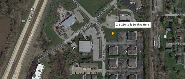
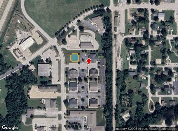
This Property Is For Sale
NEARBY LISTINGS FOR SALE OR LEASE
-
-
View all Kearney listings for sale on LoopNet.com
Property Detail
151 S Platte Clay Way
Kansas City, MO-KS
Northland Business Center
07-812-00-11-012.01
NORTHLAND BUSINESS CENTER REPLAT LTS 6 & 7 BLDG A LT 7
Commercialacreage
Clay
X
Missouri
29047C0151E
6,7
2024
0.15 AC
2025
I-35 Corridor
021806
Kansas City
DEMOGRAPHICS near 151 S Platte Clay Way
1 Mile
3 Mile
5 Mile
2024 Total Population
4,359
13,099
17,697
2029 Population
4,558
13,748
18,551
Pop Growth 2024-2029
+ 4.57%
+ 4.95%
+ 4.83%
Average Age
41
40
41
2024 Total Households
1,792
4,859
6,513
HH Growth 2024-2029
+ 4.69%
+ 4.96%
+ 4.82%
Median Household Inc
$66,611
$93,323
$95,735
Avg Household Size
2.40
2.70
2.70
2024 Avg HH Vehicles
2.00
3.00
3.00
Median Home Value
$219,529
$275,362
$301,545
Median Year Built
1994
1997
1995
Nearby Places
- Restaurants
- Banks
- Shops
- Fitness
- Groceries
PUBLIC TRANSPORTATION
AIRPORT
Kansas City International
DRIVE
WALK
Distance
Kansas City International
35 min
26.4 mi
Freight Ports
Tulsa Port Of Catoosa
DRIVE
WALK
Distance
Tulsa Port Of Catoosa
296 min
262.9 mi
Nearby Properties
Address
Land Use
TOTAL SIZE
Lot Size
Zoning
Address
Land Use
TOTAL SIZE
Lot Size
Zoning
61.30 AC
Address
Land Use
TOTAL SIZE
Lot Size
Zoning
22.08 AC
Address
Land Use
TOTAL SIZE
Lot Size
Zoning
6.17 AC
Address
Land Use
TOTAL SIZE
Lot Size
Zoning
35.96 AC
Address
Land Use
TOTAL SIZE
Lot Size
Zoning
21.24 AC
Address
Land Use
TOTAL SIZE
Lot Size
Zoning
36.74 AC
Address
Land Use
TOTAL SIZE
Lot Size
Zoning
Address
Land Use
TOTAL SIZE
Lot Size
Zoning
2.96 AC
Address
Land Use
TOTAL SIZE
Lot Size
Zoning
9.68 AC
Address
Land Use
TOTAL SIZE
Lot Size
Zoning
5,807 SF
4.12 AC
Address
Land Use
TOTAL SIZE
Lot Size
Zoning
16.51 AC
Address
Land Use
TOTAL SIZE
Lot Size
Zoning
3.75 AC
Address
Land Use
TOTAL SIZE
Lot Size
Zoning
29.71 AC
Address
Land Use
TOTAL SIZE
Lot Size
Zoning
Address
Land Use
TOTAL SIZE
Lot Size
Zoning
Address
Land Use
TOTAL SIZE
Lot Size
Zoning
64.84 AC
Address
Land Use
TOTAL SIZE
Lot Size
Zoning
Address
Land Use
TOTAL SIZE
Lot Size
Zoning
4.71 AC
Address
Land Use
TOTAL SIZE
Lot Size
Zoning
7.09 AC
Address
Land Use
TOTAL SIZE
Lot Size
Zoning
12.42 AC
Address
Land Use
TOTAL SIZE
Lot Size
Zoning
20.01 AC
Address
Land Use
TOTAL SIZE
Lot Size
Zoning
Address
Land Use
TOTAL SIZE
Lot Size
Zoning
Address
Land Use
TOTAL SIZE
Lot Size
Zoning
9.73 AC
Address
Land Use
TOTAL SIZE
Lot Size
Zoning
4.33 AC
Address
Land Use
TOTAL SIZE
Lot Size
Zoning
6.25 AC
Address
Land Use
TOTAL SIZE
Lot Size
Zoning
2.01 AC
Address
Land Use
TOTAL SIZE
Lot Size
Zoning
1.26 AC
Address
Land Use
TOTAL SIZE
Lot Size
Zoning
Address
Land Use
TOTAL SIZE
Lot Size
Zoning
The World's #1 Commercial Real Estate Marketplace
Connect with us
© 2025 CoStar Group
The information above has been obtained from sources believed reliable. While we do not doubt its accuracy we have not verified it and make no guarantee, warranty or representation about it. It is your responsibility to independently confirm its accuracy and completeness. Any projections, opinions, assumptions, or estimates used are for example only and do not represent the current or future performance of the property. The value of this transaction to you depends on tax and other factors which should be evaluated by your tax, financial, and legal advisors. You and your advisors should conduct a careful, independent investigation of the property to determine to your satisfaction the suitability of the property for your needs.