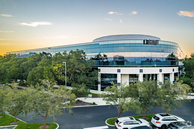
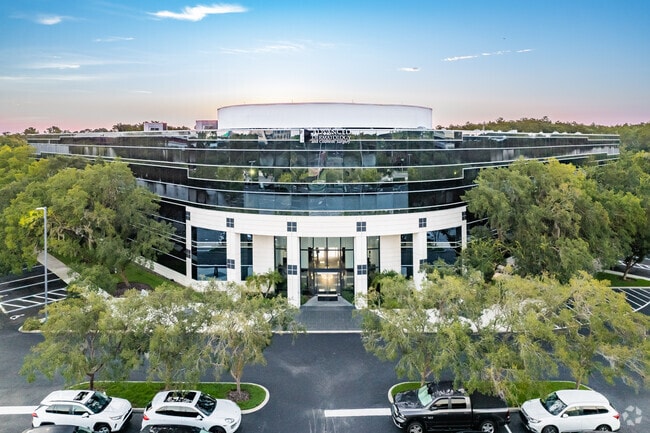
Property Record
151 Southhall Ln, Maitland, FL 32751

Current Lease Availabilities
NEARBY LISTINGS FOR SALE OR LEASE
Property Detail
151 Southhall Ln
Orlando-Kissimmee-Sanford, FL
Maitland Ctr Sec 15
27-2129-5510-01-002
MAITLAND CENTER SECTION 15 15/3 BEG 714.45 FT N OF SW COR OF SAID SUB RUN E 582.17 FT NELY 919.41 FT N 10 FT W 1285.6 FT S 594.19 FT TO POB (LESS BEG NW COR MAITLAND CENTER SECTION
Officebuilding
Orange
X
Florida
12095C0145F
2
2024
9.09 AC
2025
Maitland Center
015203
Orlando
150,817 SF
DEMOGRAPHICS near 151 Southhall Ln
1 Mile
3 Mile
5 Mile
2024 Total Population
8,400
100,089
261,521
2029 Population
8,725
103,955
271,935
Pop Growth 2024-2029
+ 3.87%
+ 3.86%
+ 3.98%
Average Age
37
40
41
2024 Total Households
3,911
43,666
108,950
HH Growth 2024-2029
+ 3.99%
+ 4.05%
+ 4.23%
Median Household Inc
$63,914
$57,643
$62,085
Avg Household Size
2.10
2.20
2.30
2024 Avg HH Vehicles
2.00
2.00
2.00
Median Home Value
$257,392
$284,729
$318,671
Median Year Built
1999
1982
1980
Nearby Places
Map Layers
Map Styles
 Street
 Aerial
- Restaurants
- Banks
- Shops
- Fitness
- Groceries
PUBLIC TRANSPORTATION
COMMUTER RAIL
DRIVE
WALK
Distance
6 min
3.1 mi
DRIVE
WALK
Distance
11 min
5.2 mi
AIRPORT
Orlando Sanford International
DRIVE
WALK
Distance
Orlando Sanford International
30 min
18.7 mi
Orlando International
DRIVE
WALK
Distance
Orlando International
33 min
19.9 mi
Nearby Properties
Address
Land Use
TOTAL SIZE
Lot Size
Zoning
Address
Land Use
TOTAL SIZE
Lot Size
Zoning
502,971 SF
30.54 AC
C-1
Address
Land Use
TOTAL SIZE
Lot Size
Zoning
1,009,074 SF
37.77 AC
PD
Address
Land Use
TOTAL SIZE
Lot Size
Zoning
630,861 SF
31.68 AC
PUDMO
Address
Land Use
TOTAL SIZE
Lot Size
Zoning
88,256 SF
39.64 AC
MOC3
Address
Land Use
TOTAL SIZE
Lot Size
Zoning
34,430 SF
19.99 AC
Address
Land Use
TOTAL SIZE
Lot Size
Zoning
507,541 SF
49.48 AC
I-1
Address
Land Use
TOTAL SIZE
Lot Size
Zoning
423,270 SF
3.45 AC
MOC3
Address
Land Use
TOTAL SIZE
Lot Size
Zoning
467,832 SF
20.10 AC
PD
Address
Land Use
TOTAL SIZE
Lot Size
Zoning
1,674 SF
10.53 AC
R3
Address
Land Use
TOTAL SIZE
Lot Size
Zoning
357 SF
17.05 AC
Address
Land Use
TOTAL SIZE
Lot Size
Zoning
538,389 SF
3.25 AC
OC-PD
Address
Land Use
TOTAL SIZE
Lot Size
Zoning
464,785 SF
2.19 AC
R-MF
Address
Land Use
TOTAL SIZE
Lot Size
Zoning
482,097 SF
2.42 AC
OC-PD
Address
Land Use
TOTAL SIZE
Lot Size
Zoning
468,719 SF
45.46 AC
PD
Address
Land Use
TOTAL SIZE
Lot Size
Zoning
656,009 SF
5.59 AC
DM
Address
Land Use
TOTAL SIZE
Lot Size
Zoning
Address
Land Use
TOTAL SIZE
Lot Size
Zoning
563,546 SF
0.61 AC
DM
Address
Land Use
TOTAL SIZE
Lot Size
Zoning
381,557 SF
10.09 AC
PD
Address
Land Use
TOTAL SIZE
Lot Size
Zoning
555,833 SF
3.65 AC
DM
Address
Land Use
TOTAL SIZE
Lot Size
Zoning
505,902 SF
4.69 AC
DM
Address
Land Use
TOTAL SIZE
Lot Size
Zoning
5,256 SF
1.10 AC
PUDRES
Address
Land Use
TOTAL SIZE
Lot Size
Zoning
277,160 SF
2.38 AC
R-MF
Address
Land Use
TOTAL SIZE
Lot Size
Zoning
11,392 SF
8.44 AC
Address
Land Use
TOTAL SIZE
Lot Size
Zoning
396,016 SF
4.45 AC
R-4
Address
Land Use
TOTAL SIZE
Lot Size
Zoning
631,978 SF
7 AC
PD
Address
Land Use
TOTAL SIZE
Lot Size
Zoning
135,028 SF
27.59 AC
PR
Address
Land Use
TOTAL SIZE
Lot Size
Zoning
341,947 SF
1.13 AC
PD
Address
Land Use
TOTAL SIZE
Lot Size
Zoning
385,111 SF
12.39 AC
PD
Address
Land Use
TOTAL SIZE
Lot Size
Zoning
1,170 SF
17.75 AC
A1
Address
Land Use
TOTAL SIZE
Lot Size
Zoning
269,919 SF
24.44 AC
R-3
The World's #1 Commercial Real Estate Marketplace
Connect with us
© 2026 CoStar Group
The information above has been obtained from sources believed reliable. While we do not doubt its accuracy we have not verified it and make no guarantee, warranty or representation about it. It is your responsibility to independently confirm its accuracy and completeness. Any projections, opinions, assumptions, or estimates used are for example only and do not represent the current or future performance of the property. The value of this transaction to you depends on tax and other factors which should be evaluated by your tax, financial, and legal advisors. You and your advisors should conduct a careful, independent investigation of the property to determine to your satisfaction the suitability of the property for your needs.