Property Record
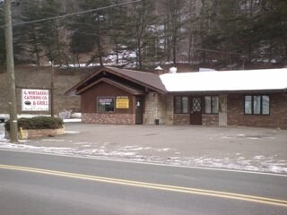
151 State Route 239, Shickshinny, PA 18655


NEARBY LISTINGS FOR SALE OR LEASE
Property Detail
151 State Route 239
Scranton--Wilkes-Barre--Hazelton, PA
Pine Cone Subdivision
61-K4S1-003-017-000
MAP 253P56
Restaurantbuilding
Luzerne
X
Pennsylvania
42079C0316E
17
2025
1.26 AC
2025
I-81 Corridor
215702
Philadelphia
DEMOGRAPHICS near 151 State Route 239
1 Mile
3 Mile
5 Mile
2024 Total Population
516
2,893
8,344
2029 Population
523
2,903
8,399
Pop Growth 2024-2029
+ 1.36%
+ 0.35%
+ 0.66%
Average Age
44
45
43
2024 Total Households
217
1,244
3,577
HH Growth 2024-2029
+ 0.92%
+ 0.24%
+ 0.59%
Median Household Inc
$74,999
$69,191
$59,789
Avg Household Size
2.40
2.30
2.30
2024 Avg HH Vehicles
2.00
2.00
2.00
Median Home Value
$204,651
$174,215
$154,353
Median Year Built
1970
1965
1957
Nearby Places
Map Layers
Map Styles
 Street
 Aerial
- Restaurants
- Banks
- Shops
- Fitness
- Groceries
PUBLIC TRANSPORTATION
AIRPORT
Wilkes-Barre/Scranton International
DRIVE
WALK
Distance
Wilkes-Barre/Scranton International
48 min
30.7 mi
Freight Ports
Port of Philadelphia
DRIVE
WALK
Distance
Port of Philadelphia
165 min
131.2 mi
Nearby Properties
Address
Land Use
TOTAL SIZE
Lot Size
Zoning
Address
Land Use
TOTAL SIZE
Lot Size
Zoning
24.27 AC
Address
Land Use
TOTAL SIZE
Lot Size
Zoning
3,115 AC
Address
Land Use
TOTAL SIZE
Lot Size
Zoning
0.97 AC
Address
Land Use
TOTAL SIZE
Lot Size
Zoning
1.36 AC
Address
Land Use
TOTAL SIZE
Lot Size
Zoning
1.25 AC
Address
Land Use
TOTAL SIZE
Lot Size
Zoning
0.08 AC
Address
Land Use
TOTAL SIZE
Lot Size
Zoning
330.92 AC
Address
Land Use
TOTAL SIZE
Lot Size
Zoning
2,160 SF
0.47 AC
Address
Land Use
TOTAL SIZE
Lot Size
Zoning
0.56 AC
Address
Land Use
TOTAL SIZE
Lot Size
Zoning
Address
Land Use
TOTAL SIZE
Lot Size
Zoning
Address
Land Use
TOTAL SIZE
Lot Size
Zoning
0.09 AC
Address
Land Use
TOTAL SIZE
Lot Size
Zoning
0.83 AC
Address
Land Use
TOTAL SIZE
Lot Size
Zoning
1.46 AC
Address
Land Use
TOTAL SIZE
Lot Size
Zoning
1,700 SF
0.75 AC
Address
Land Use
TOTAL SIZE
Lot Size
Zoning
1,960 SF
2.07 AC
Address
Land Use
TOTAL SIZE
Lot Size
Zoning
0.32 AC
Address
Land Use
TOTAL SIZE
Lot Size
Zoning
0.16 AC
Address
Land Use
TOTAL SIZE
Lot Size
Zoning
0.14 AC
Address
Land Use
TOTAL SIZE
Lot Size
Zoning
Address
Land Use
TOTAL SIZE
Lot Size
Zoning
101.17 AC
Address
Land Use
TOTAL SIZE
Lot Size
Zoning
0.13 AC
Address
Land Use
TOTAL SIZE
Lot Size
Zoning
0.09 AC
Address
Land Use
TOTAL SIZE
Lot Size
Zoning
1,620 SF
1.52 AC
Address
Land Use
TOTAL SIZE
Lot Size
Zoning
1,867 SF
1.82 AC
Address
Land Use
TOTAL SIZE
Lot Size
Zoning
168 AC
Address
Land Use
TOTAL SIZE
Lot Size
Zoning
2,282 SF
3.20 AC
Address
Land Use
TOTAL SIZE
Lot Size
Zoning
Address
Land Use
TOTAL SIZE
Lot Size
Zoning
0.15 AC
Address
Land Use
TOTAL SIZE
Lot Size
Zoning
2.02 AC
The World's #1 Commercial Real Estate Marketplace
Connect with us
© 2026 CoStar Group
The information above has been obtained from sources believed reliable. While we do not doubt its accuracy we have not verified it and make no guarantee, warranty or representation about it. It is your responsibility to independently confirm its accuracy and completeness. Any projections, opinions, assumptions, or estimates used are for example only and do not represent the current or future performance of the property. The value of this transaction to you depends on tax and other factors which should be evaluated by your tax, financial, and legal advisors. You and your advisors should conduct a careful, independent investigation of the property to determine to your satisfaction the suitability of the property for your needs.