Property Record
151 Two Rod Rd, Scarborough, ME 04074
Save to a Folder
{{folder.Name}}
{{folder.ListingIds.length}} Properties
{{folder.ListingIds.length}} Property
Create a New Folder
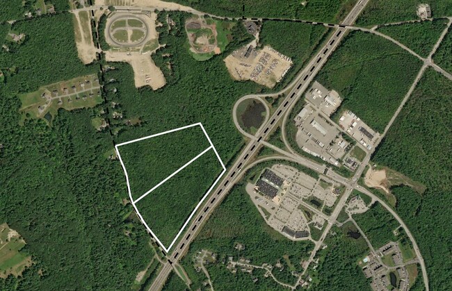
Property Detail
151 Two Rod Rd
SCAR-000032R-000000-000022
CUMBERLAND
Residentialacreage
Maine
40
22
B and X Area of moderate flood hazard, usually the area between the limits of the 100-year and 500-year floods.
23.78 AC
2025
SW Cumberland County
2025
Portland/South Portland
017306
Portland-South Portland, ME
NEARBY LISTINGS FOR SALE OR LEASE
DEMOGRAPHICS near 151 Two Rod Rd
1 mile
3 mile
5 mile
2025 Total Population
1,450
13,636
44,021
2030 Population
1,507
13,993
45,083
Pop Growth 2025-2030
+ 3.93%
+ 2.62%
+ 2.41%
Average Age
42
44
43
2025 Total Households
594
5,565
18,285
HH Growth 2025-2030
+ 4.38%
+ 2.93%
+ 2.74%
Median Household Inc
$95,070
$106,920
$103,679
Avg Household Size
2.40
2.40
2.30
2025 Avg HH Vehicles
2.00
2.00
2.00
Median Home Value
$573,604
$506,986
$468,698
Median Year Built
2003
1993
1984
Nearby Places
Map Layers
Map Styles
 Street
 Aerial
Layers
 Traffic
 Biking
Places
Listings with unknown addresses are not visible on the map
- Restaurants
- Banks
- Shops
- Fitness
- Groceries
PUBLIC TRANSPORTATION
COMMUTER RAIL
Portland (Downeaster - Amtrak)
Drive
Walk
Distance
Portland (Downeaster - Amtrak)
14 min
8.2 mi
AIRPORT
Portland International Jetport
Drive
Walk
Distance
Portland International Jetport
15 min
6.8 mi
Freight Ports
Portland, ME
Drive
Walk
Distance
Portland, ME
16 min
9.4 mi
SALE & LEASE HISTORY
LISTING DATE
SALE/LEASE

Sep 16, 2022
For Sale
Sep 02, 2022
For Sale
Nearby Properties
Address
Land Use
TOTAL SIZE
Lot Size
Zoning
Address
Land Use
TOTAL SIZE
Lot Size
Zoning
28.33 AC
24
Address
Land Use
TOTAL SIZE
Lot Size
Zoning
114,704 SF
24.60 AC
39
Address
Land Use
TOTAL SIZE
Lot Size
Zoning
401,800 SF
51.38 AC
31
Address
Land Use
TOTAL SIZE
Lot Size
Zoning
176,100 SF
128 AC
Z
Address
Land Use
TOTAL SIZE
Lot Size
Zoning
115,965 SF
123 AC
Z
Address
Land Use
TOTAL SIZE
Lot Size
Zoning
129,885 SF
28.33 AC
24
Address
Land Use
TOTAL SIZE
Lot Size
Zoning
113,025 SF
7.30 AC
31
Address
Land Use
TOTAL SIZE
Lot Size
Zoning
217,672 SF
17.80 AC
Z
Address
Land Use
TOTAL SIZE
Lot Size
Zoning
14.51 AC
Z
Address
Land Use
TOTAL SIZE
Lot Size
Zoning
116,600 SF
12.37 AC
Z
Address
Land Use
TOTAL SIZE
Lot Size
Zoning
16 AC
26
Address
Land Use
TOTAL SIZE
Lot Size
Zoning
18.83 AC
22
Address
Land Use
TOTAL SIZE
Lot Size
Zoning
226,870 SF
26.38 AC
22
Address
Land Use
TOTAL SIZE
Lot Size
Zoning
5.15 AC
MM
Address
Land Use
TOTAL SIZE
Lot Size
Zoning
160,311 SF
19.25 AC
39
Address
Land Use
TOTAL SIZE
Lot Size
Zoning
880 SF
25.60 AC
26
Address
Land Use
TOTAL SIZE
Lot Size
Zoning
1,303 SF
11.32 AC
27
Address
Land Use
TOTAL SIZE
Lot Size
Zoning
117,195 SF
8.08 AC
Address
Land Use
TOTAL SIZE
Lot Size
Zoning
109,988 SF
14.51 AC
33
Address
Land Use
TOTAL SIZE
Lot Size
Zoning
2,880 SF
176.89 AC
22
Address
Land Use
TOTAL SIZE
Lot Size
Zoning
110,378 SF
22.01 AC
Z
Address
Land Use
TOTAL SIZE
Lot Size
Zoning
Address
Land Use
TOTAL SIZE
Lot Size
Zoning
6.25 AC
34
Address
Land Use
TOTAL SIZE
Lot Size
Zoning
7.46 AC
Z
Address
Land Use
TOTAL SIZE
Lot Size
Zoning
117,382 SF
21.61 AC
22
Address
Land Use
TOTAL SIZE
Lot Size
Zoning
3.44 AC
27
Address
Land Use
TOTAL SIZE
Lot Size
Zoning
87,792 SF
11.44 AC
MM
Address
Land Use
TOTAL SIZE
Lot Size
Zoning
72,214 SF
22 AC
26
Address
Land Use
TOTAL SIZE
Lot Size
Zoning
53,624 SF
11.43 AC
TIFD
Address
Land Use
TOTAL SIZE
Lot Size
Zoning
138,046 SF
14.81 AC
22
The World's #1 Commercial Real Estate Marketplace
Connect with us
© 2026 CoStar Group
The information above has been obtained from sources believed reliable. While we do not doubt its accuracy we have not verified it and make no guarantee, warranty or representation about it. It is your responsibility to independently confirm its accuracy and completeness. Any projections, opinions, assumptions, or estimates used are for example only and do not represent the current or future performance of the property. The value of this transaction to you depends on tax and other factors which should be evaluated by your tax, financial, and legal advisors. You and your advisors should conduct a careful, independent investigation of the property to determine to your satisfaction the suitability of the property for your needs.