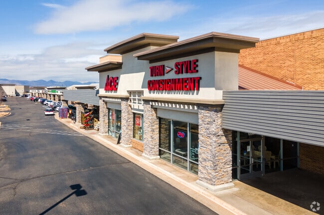
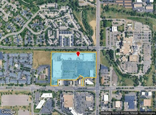
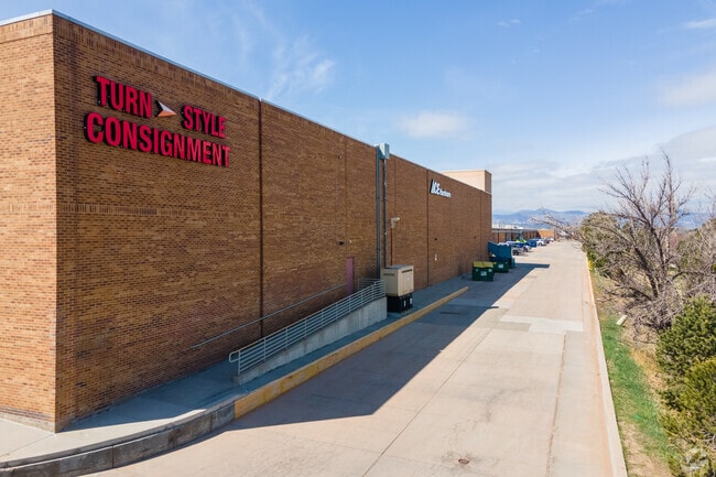
Property Record
151 W Mineral Ave, Littleton, CO 80120

NEARBY LISTINGS FOR SALE OR LEASE
Property Detail
151 W Mineral Ave
Denver-Aurora-Centennial, CO
Southbridge Retail Center Sub 1St Flg
2077-34-2-06-001
SUBDIVISIONCD 057720 SUBDIVISIONNAME SOUTHBRIDGE RETAIL CENTER SUB 1ST FLG BLOCK 001 LOT 001 LOT 1 BLK 1 SOUTHBRIDGE RETAIL CENTER 1ST FLG EX M/R
Storebuilding
Arapahoe
X
Colorado
08005C0453L
1
2024
16 AC
2025
South
005633
Denver
187,486 SF
DEMOGRAPHICS near 151 W Mineral Ave
1 Mile
3 Mile
5 Mile
2024 Total Population
11,674
103,189
254,179
2029 Population
12,091
109,034
266,800
Pop Growth 2024-2029
+ 3.57%
+ 5.66%
+ 4.97%
Average Age
42
43
42
2024 Total Households
4,707
41,971
99,180
HH Growth 2024-2029
+ 4.44%
+ 5.84%
+ 4.83%
Median Household Inc
$121,896
$112,293
$118,235
Avg Household Size
2.40
2.40
2.50
2024 Avg HH Vehicles
2.00
2.00
2.00
Median Home Value
$648,642
$635,323
$638,964
Median Year Built
1986
1985
1986
Nearby Places
Map Layers
Map Styles
 Street
 Aerial
- Restaurants
- Banks
- Shops
- Fitness
- Groceries
PUBLIC TRANSPORTATION
AIRPORT
Denver International
DRIVE
WALK
Distance
Denver International
46 min
40.8 mi
Freight Ports
Tulsa Port Of Catoosa
DRIVE
WALK
Distance
Tulsa Port Of Catoosa
739 min
720.7 mi
SALE & LEASE HISTORY
LISTING DATE
SALE/LEASE

Sep 24, 2016
For Lease
Oct 16, 2017
For Lease
Nearby Properties
Address
Land Use
TOTAL SIZE
Lot Size
Zoning
Address
Land Use
TOTAL SIZE
Lot Size
Zoning
867,858 SF
21.49 AC
Address
Land Use
TOTAL SIZE
Lot Size
Zoning
481,147 SF
38.27 AC
Address
Land Use
TOTAL SIZE
Lot Size
Zoning
251,583 SF
38.03 AC
Address
Land Use
TOTAL SIZE
Lot Size
Zoning
187,769 SF
16.09 AC
Address
Land Use
TOTAL SIZE
Lot Size
Zoning
622,103 SF
24.61 AC
PDU
Address
Land Use
TOTAL SIZE
Lot Size
Zoning
206,632 SF
33.68 AC
Address
Land Use
TOTAL SIZE
Lot Size
Zoning
345,126 SF
21.94 AC
Address
Land Use
TOTAL SIZE
Lot Size
Zoning
250,402 SF
21 AC
Address
Land Use
TOTAL SIZE
Lot Size
Zoning
14,029 SF
23.97 AC
Address
Land Use
TOTAL SIZE
Lot Size
Zoning
38,992 SF
1 AC
Address
Land Use
TOTAL SIZE
Lot Size
Zoning
42,444 SF
1.41 AC
Address
Land Use
TOTAL SIZE
Lot Size
Zoning
58,006 SF
1.80 AC
Address
Land Use
TOTAL SIZE
Lot Size
Zoning
1,806,344 SF
54.66 AC
Address
Land Use
TOTAL SIZE
Lot Size
Zoning
329,937 SF
35.07 AC
PUD
Address
Land Use
TOTAL SIZE
Lot Size
Zoning
215,900 SF
15.32 AC
PDU
Address
Land Use
TOTAL SIZE
Lot Size
Zoning
192,108 SF
20.03 AC
Address
Land Use
TOTAL SIZE
Lot Size
Zoning
167,287 SF
13.65 AC
Address
Land Use
TOTAL SIZE
Lot Size
Zoning
133,908 SF
9.39 AC
LPD-C
Address
Land Use
TOTAL SIZE
Lot Size
Zoning
150,767 SF
14.49 AC
PDU
Address
Land Use
TOTAL SIZE
Lot Size
Zoning
411,924 SF
26.85 AC
LPDI
Address
Land Use
TOTAL SIZE
Lot Size
Zoning
519,330 SF
22.81 AC
PDU
Address
Land Use
TOTAL SIZE
Lot Size
Zoning
484,245 SF
18.06 AC
Address
Land Use
TOTAL SIZE
Lot Size
Zoning
572,657 SF
0.21 AC
LPD-C
Address
Land Use
TOTAL SIZE
Lot Size
Zoning
152,384 SF
12.89 AC
PDU
Address
Land Use
TOTAL SIZE
Lot Size
Zoning
312,130 SF
20.63 AC
PDU
Address
Land Use
TOTAL SIZE
Lot Size
Zoning
90,350 SF
11.44 AC
Address
Land Use
TOTAL SIZE
Lot Size
Zoning
1,036,325 SF
51.26 AC
PDU
Address
Land Use
TOTAL SIZE
Lot Size
Zoning
463,840 SF
17.63 AC
PDU
Address
Land Use
TOTAL SIZE
Lot Size
Zoning
63,732 SF
1.58 AC
The World's #1 Commercial Real Estate Marketplace
Connect with us
© 2026 CoStar Group
The information above has been obtained from sources believed reliable. While we do not doubt its accuracy we have not verified it and make no guarantee, warranty or representation about it. It is your responsibility to independently confirm its accuracy and completeness. Any projections, opinions, assumptions, or estimates used are for example only and do not represent the current or future performance of the property. The value of this transaction to you depends on tax and other factors which should be evaluated by your tax, financial, and legal advisors. You and your advisors should conduct a careful, independent investigation of the property to determine to your satisfaction the suitability of the property for your needs.