Property Record
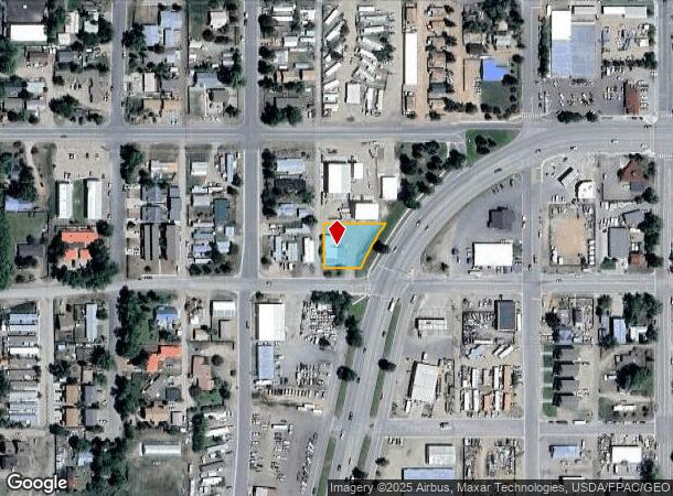
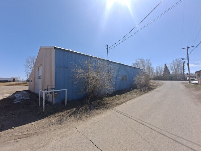
151 W Us Highway 50, Gunnison, CO 81230


Property Detail
151 W Us Highway 50
R071761
Salmon Property Boundary Line Adjustment
Storebuilding
TRACT D, BLOCK 21, WEST GUNISON
X
Gunnison
08051C1262D
Colorado
2025
0.38 AC
2025
Colorado Southwest Area
963701
Other Market Areas
4,320 SF
NEARBY LISTINGS FOR SALE OR LEASE
-
-
View all Gunnison listings for lease on LoopNet.com
DEMOGRAPHICS near 151 W Us Highway 50
1 mile
3 mile
5 mile
2024 Total Population
5,030
9,119
9,951
2029 Population
5,260
9,608
10,511
Pop Growth 2024-2029
+ 4.57%
+ 5.36%
+ 5.63%
Average Age
36
36
36
2024 Total Households
2,147
3,664
4,019
HH Growth 2024-2029
+ 4.75%
+ 5.62%
+ 5.92%
Median Household Inc
$52,261
$55,079
$57,222
Avg Household Size
2.20
2.20
2.20
2024 Avg HH Vehicles
2.00
2.00
2.00
Median Home Value
$375,647
$410,887
$432,233
Median Year Built
1984
1982
1983
Nearby Places
Map Layers
Map Styles
 Street
 Aerial
Transit
 Traffic
 Biking
Places
Listings with unknown addresses are not visible on the map
- Restaurants
- Banks
- Shops
- Fitness
- Groceries
PUBLIC TRANSPORTATION
AIRPORT
Gunnison-Crested Butte Regional
Drive
Walk
Distance
Gunnison-Crested Butte Regional
14 min
3.2 mi
SALE & LEASE HISTORY
LISTING DATE
SALE/LEASE

Jun 16, 2021
For Lease
Apr 14, 2022
For Lease
Nearby Properties
Address
Land Use
TOTAL SIZE
Lot Size
Zoning
Address
Land Use
TOTAL SIZE
Lot Size
Zoning
38,866 SF
7.50 AC
Address
Land Use
TOTAL SIZE
Lot Size
Zoning
38,866 SF
7.50 AC
Address
Land Use
TOTAL SIZE
Lot Size
Zoning
67,817 SF
5.11 AC
Address
Land Use
TOTAL SIZE
Lot Size
Zoning
24.45 AC
Address
Land Use
TOTAL SIZE
Lot Size
Zoning
49,153 SF
3.92 AC
Address
Land Use
TOTAL SIZE
Lot Size
Zoning
10,802 SF
3.04 AC
Address
Land Use
TOTAL SIZE
Lot Size
Zoning
29,429 SF
10.21 AC
Address
Land Use
TOTAL SIZE
Lot Size
Zoning
6,282 SF
0.25 AC
Address
Land Use
TOTAL SIZE
Lot Size
Zoning
48,839 SF
4.56 AC
Address
Land Use
TOTAL SIZE
Lot Size
Zoning
994 SF
1.81 AC
Address
Land Use
TOTAL SIZE
Lot Size
Zoning
30,330 SF
1.64 AC
Address
Land Use
TOTAL SIZE
Lot Size
Zoning
43,938 SF
4.81 AC
Address
Land Use
TOTAL SIZE
Lot Size
Zoning
9,600 SF
5.13 AC
Address
Land Use
TOTAL SIZE
Lot Size
Zoning
30,496 SF
0.86 AC
Address
Land Use
TOTAL SIZE
Lot Size
Zoning
12,690 SF
3.80 AC
Address
Land Use
TOTAL SIZE
Lot Size
Zoning
11,637 SF
1.31 AC
Address
Land Use
TOTAL SIZE
Lot Size
Zoning
Address
Land Use
TOTAL SIZE
Lot Size
Zoning
15,948 SF
3.69 AC
Address
Land Use
TOTAL SIZE
Lot Size
Zoning
22,080 SF
2.46 AC
Address
Land Use
TOTAL SIZE
Lot Size
Zoning
Address
Land Use
TOTAL SIZE
Lot Size
Zoning
Address
Land Use
TOTAL SIZE
Lot Size
Zoning
12,235 SF
0.70 AC
Address
Land Use
TOTAL SIZE
Lot Size
Zoning
29,860 SF
1.72 AC
Address
Land Use
TOTAL SIZE
Lot Size
Zoning
36,468 SF
1.86 AC
Address
Land Use
TOTAL SIZE
Lot Size
Zoning
19,446 SF
1.29 AC
Address
Land Use
TOTAL SIZE
Lot Size
Zoning
1.07 AC
Address
Land Use
TOTAL SIZE
Lot Size
Zoning
9,900 SF
3.22 AC
Address
Land Use
TOTAL SIZE
Lot Size
Zoning
Address
Land Use
TOTAL SIZE
Lot Size
Zoning
21,987 SF
1.72 AC
Address
Land Use
TOTAL SIZE
Lot Size
Zoning
22,538 SF
1.52 AC
The World's #1 Commercial Real Estate Marketplace
Connect with us
© 2026 CoStar Group
The information above has been obtained from sources believed reliable. While we do not doubt its accuracy we have not verified it and make no guarantee, warranty or representation about it. It is your responsibility to independently confirm its accuracy and completeness. Any projections, opinions, assumptions, or estimates used are for example only and do not represent the current or future performance of the property. The value of this transaction to you depends on tax and other factors which should be evaluated by your tax, financial, and legal advisors. You and your advisors should conduct a careful, independent investigation of the property to determine to your satisfaction the suitability of the property for your needs.