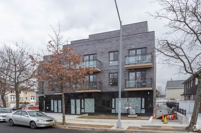
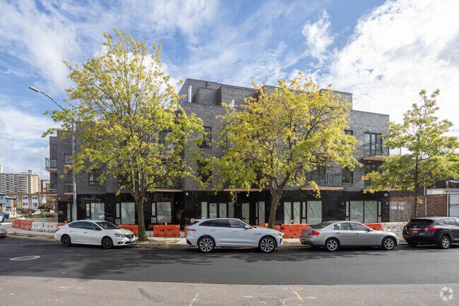
Property Record
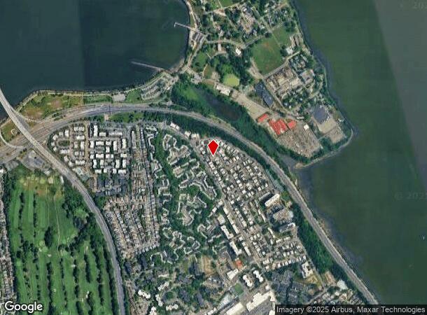
1510 215Th St, Bayside, NY 11360
NEARBY LISTINGS FOR SALE OR LEASE
Property Detail
1510 215Th St
05944-0054
Queens
Apartment
New York
X
54
36059C0092G
0.26 AC
2023
Bayside
2024
Long Island (New York)
099703
New York-Jersey City-White Plains, NY-NJ
19,334 SF
DEMOGRAPHICS near 1510 215Th St
1 Mile
3 Mile
5 Mile
2024 Total Population
21,160
262,835
734,984
2029 Population
19,983
247,596
685,748
Pop Growth 2024-2029
(5.56%)
(5.80%)
(6.70%)
Average Age
50
45
43
2024 Total Households
9,600
94,938
254,929
HH Growth 2024-2029
(5.79%)
(6.13%)
(7.06%)
Median Household Inc
$93,091
$78,700
$73,528
Avg Household Size
2.20
2.70
2.70
2024 Avg HH Vehicles
1.00
1.00
1.00
Median Home Value
$649,041
$773,397
$741,388
Median Year Built
1965
1956
1955
Nearby Places
- Restaurants
- Banks
- Shops
- Fitness
- Groceries
PUBLIC TRANSPORTATION
COMMUTER RAIL
Bayside Station (Port Washington Branch - Long Island Rail Road)
DRIVE
WALK
Distance
Bayside Station (Port Washington Branch - Long Island Rail Road)
5 min
1.9 mi
Auburndale Station (Port Washington Branch - Long Island Rail Road)
DRIVE
WALK
Distance
Auburndale Station (Port Washington Branch - Long Island Rail Road)
6 min
2.9 mi
AIRPORT
LaGuardia
DRIVE
WALK
Distance
LaGuardia
14 min
7.2 mi
John F Kennedy International
DRIVE
WALK
Distance
John F Kennedy International
21 min
14.8 mi
Westchester County
DRIVE
WALK
Distance
Westchester County
41 min
26.3 mi
Freight Ports
NY - Red Hook Container Terminal
DRIVE
WALK
Distance
NY - Red Hook Container Terminal
29 min
17.7 mi
Nearby Properties
Address
Land Use
TOTAL SIZE
Lot Size
Zoning
Address
Land Use
TOTAL SIZE
Lot Size
Zoning
2,697,663 SF
3.46 AC
C5-3
Address
Land Use
TOTAL SIZE
Lot Size
Zoning
1,666,696 SF
1.87 AC
C52.5
Address
Land Use
TOTAL SIZE
Lot Size
Zoning
878,386 SF
20.55 AC
R4
Address
Land Use
TOTAL SIZE
Lot Size
Zoning
703,265 SF
83.45 AC
R4
Address
Land Use
TOTAL SIZE
Lot Size
Zoning
421,996 SF
136.05 AC
R3-1
Address
Land Use
TOTAL SIZE
Lot Size
Zoning
4,050 SF
113.40 AC
PARK
Address
Land Use
TOTAL SIZE
Lot Size
Zoning
511,684 SF
13.09 AC
R4
Address
Land Use
TOTAL SIZE
Lot Size
Zoning
198,298 SF
13.93 AC
C4-1
Address
Land Use
TOTAL SIZE
Lot Size
Zoning
186,843 SF
5.37 AC
R2A
Address
Land Use
TOTAL SIZE
Lot Size
Zoning
382,302 SF
6.23 AC
R2A
Address
Land Use
TOTAL SIZE
Lot Size
Zoning
454,631 SF
24.61 AC
M1-1
Address
Land Use
TOTAL SIZE
Lot Size
Zoning
443,492 SF
27.75 AC
M1-1
Address
Land Use
TOTAL SIZE
Lot Size
Zoning
15.83 AC
M2-1
Address
Land Use
TOTAL SIZE
Lot Size
Zoning
95.36 AC
PARK
Address
Land Use
TOTAL SIZE
Lot Size
Zoning
426,224 SF
4.70 AC
R6
Address
Land Use
TOTAL SIZE
Lot Size
Zoning
222,656 SF
6.03 AC
R5B
Address
Land Use
TOTAL SIZE
Lot Size
Zoning
261,060 SF
3.31 AC
R3-2
Address
Land Use
TOTAL SIZE
Lot Size
Zoning
131,000 SF
3.54 AC
R4
Address
Land Use
TOTAL SIZE
Lot Size
Zoning
146,042 SF
0.50 AC
R6
Address
Land Use
TOTAL SIZE
Lot Size
Zoning
158,282 SF
2.38 AC
R4A
Address
Land Use
TOTAL SIZE
Lot Size
Zoning
135,000 SF
4.17 AC
R3A
Address
Land Use
TOTAL SIZE
Lot Size
Zoning
247,884 SF
2.20 AC
R6
Address
Land Use
TOTAL SIZE
Lot Size
Zoning
107,290 SF
8.66 AC
C4-1
Address
Land Use
TOTAL SIZE
Lot Size
Zoning
118,950 SF
0.28 AC
R7-1
Address
Land Use
TOTAL SIZE
Lot Size
Zoning
11.30 AC
PARK
Address
Land Use
TOTAL SIZE
Lot Size
Zoning
146,081 SF
2.39 AC
R5
Address
Land Use
TOTAL SIZE
Lot Size
Zoning
135,000 SF
2.59 AC
R3X
Address
Land Use
TOTAL SIZE
Lot Size
Zoning
193,975 SF
0.96 AC
R6
Address
Land Use
TOTAL SIZE
Lot Size
Zoning
139,896 SF
3.54 AC
M1-1
Address
Land Use
TOTAL SIZE
Lot Size
Zoning
400 SF
25.80 AC
PARK
The World's #1 Commercial Real Estate Marketplace
Connect with us
© 2025 CoStar Group
The information above has been obtained from sources believed reliable. While we do not doubt its accuracy we have not verified it and make no guarantee, warranty or representation about it. It is your responsibility to independently confirm its accuracy and completeness. Any projections, opinions, assumptions, or estimates used are for example only and do not represent the current or future performance of the property. The value of this transaction to you depends on tax and other factors which should be evaluated by your tax, financial, and legal advisors. You and your advisors should conduct a careful, independent investigation of the property to determine to your satisfaction the suitability of the property for your needs.