Property Record
1510 Commerce Dr, Lancaster, PA 17601

NEARBY LISTINGS FOR SALE OR LEASE
Property Detail
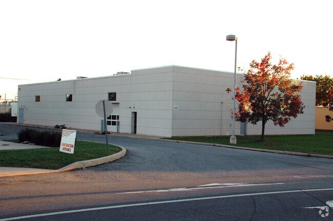
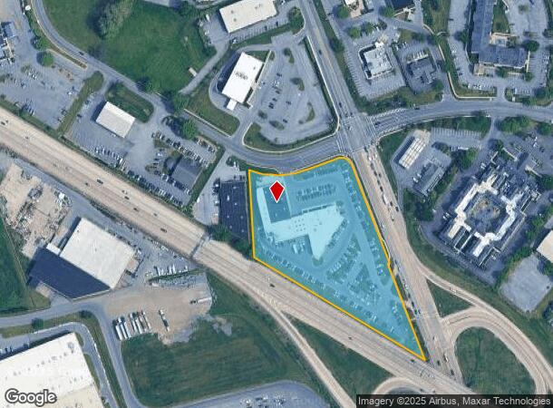
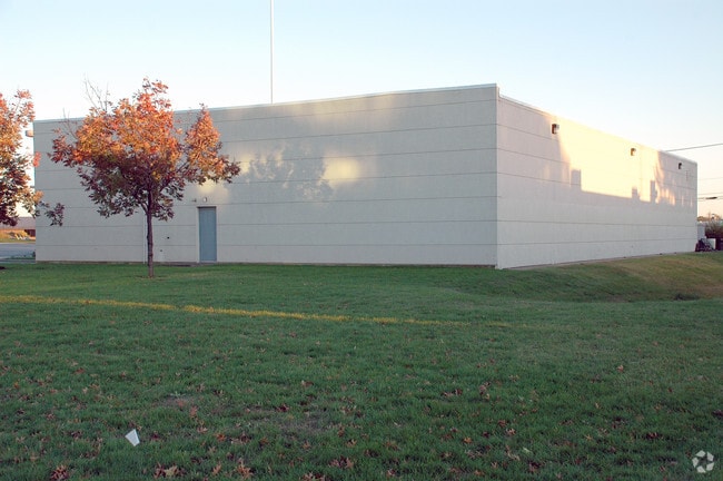
1510 Commerce Dr
Lancaster, PA
Red Rose Indust Triangle
390-24481-0-0000
1510 COMMERCE DR
Vehiclerentalsvehiclesales
Lancaster
X
Pennsylvania
42071C0354F
2
2024
4.33 AC
2025
Lancaster County
011806
Philadelphia
29,281 SF
DEMOGRAPHICS near 1510 Commerce Dr
1 Mile
3 Mile
5 Mile
2024 Total Population
5,727
71,857
184,588
2029 Population
5,674
72,544
186,224
Pop Growth 2024-2029
(0.93%)
+ 0.96%
+ 0.89%
Average Age
42
42
41
2024 Total Households
2,428
28,054
70,505
HH Growth 2024-2029
(1.57%)
+ 0.88%
+ 0.86%
Median Household Inc
$77,495
$83,337
$75,456
Avg Household Size
2.20
2.40
2.40
2024 Avg HH Vehicles
2.00
2.00
2.00
Median Home Value
$249,756
$274,131
$245,813
Median Year Built
1986
1973
1969
Nearby Places
Map Layers
Map Styles
 Street
 Aerial
- Restaurants
- Banks
- Shops
- Fitness
- Groceries
PUBLIC TRANSPORTATION
COMMUTER RAIL
Lancaster (Keystone Service - Amtrak, Pennsylvanian - Amtrak)
DRIVE
WALK
Distance
Lancaster (Keystone Service - Amtrak, Pennsylvanian - Amtrak)
5 min
3.5 mi
Mount Joy Amtrak (Keystone Service - Amtrak)
DRIVE
WALK
Distance
Mount Joy Amtrak (Keystone Service - Amtrak)
14 min
9.8 mi
AIRPORT
Harrisburg International
DRIVE
WALK
Distance
Harrisburg International
36 min
29.3 mi
Freight Ports
Port of Wilmington, RI
DRIVE
WALK
Distance
Port of Wilmington, RI
96 min
56.0 mi
Nearby Properties
Address
Land Use
TOTAL SIZE
Lot Size
Zoning
Address
Land Use
TOTAL SIZE
Lot Size
Zoning
822,920 SF
97.54 AC
HCD
Address
Land Use
TOTAL SIZE
Lot Size
Zoning
1,603,151 SF
104.89 AC
C3
Address
Land Use
TOTAL SIZE
Lot Size
Zoning
1,070,497 SF
149.62 AC
Address
Land Use
TOTAL SIZE
Lot Size
Zoning
526,898 SF
26.10 AC
AH
Address
Land Use
TOTAL SIZE
Lot Size
Zoning
1,003,686 SF
127.66 AC
HR
Address
Land Use
TOTAL SIZE
Lot Size
Zoning
822,447 SF
77.29 AC
Address
Land Use
TOTAL SIZE
Lot Size
Zoning
712,737 SF
52.50 AC
R2
Address
Land Use
TOTAL SIZE
Lot Size
Zoning
678,995 SF
96.17 AC
Address
Land Use
TOTAL SIZE
Lot Size
Zoning
905,200 SF
68.60 AC
Address
Land Use
TOTAL SIZE
Lot Size
Zoning
275,959 SF
68.50 AC
IN
Address
Land Use
TOTAL SIZE
Lot Size
Zoning
642,651 SF
2.16 AC
CA
Address
Land Use
TOTAL SIZE
Lot Size
Zoning
308,727 SF
11.37 AC
Address
Land Use
TOTAL SIZE
Lot Size
Zoning
283,042 SF
17.50 AC
Address
Land Use
TOTAL SIZE
Lot Size
Zoning
193,864 SF
9 AC
Address
Land Use
TOTAL SIZE
Lot Size
Zoning
203,415 SF
10.74 AC
Address
Land Use
TOTAL SIZE
Lot Size
Zoning
99,894 SF
21.88 AC
Address
Land Use
TOTAL SIZE
Lot Size
Zoning
135,998 SF
28.64 AC
HR
Address
Land Use
TOTAL SIZE
Lot Size
Zoning
254,079 SF
21.54 AC
Address
Land Use
TOTAL SIZE
Lot Size
Zoning
223,327 SF
21.80 AC
B-4
Address
Land Use
TOTAL SIZE
Lot Size
Zoning
203,942 SF
21.22 AC
B-4
Address
Land Use
TOTAL SIZE
Lot Size
Zoning
621,413 SF
79.20 AC
I-1
Address
Land Use
TOTAL SIZE
Lot Size
Zoning
691,290 SF
3 AC
Address
Land Use
TOTAL SIZE
Lot Size
Zoning
372,708 SF
50.40 AC
HR
Address
Land Use
TOTAL SIZE
Lot Size
Zoning
246,742 SF
12.49 AC
B-4
Address
Land Use
TOTAL SIZE
Lot Size
Zoning
128,939 SF
27.39 AC
Address
Land Use
TOTAL SIZE
Lot Size
Zoning
101,558 SF
28.14 AC
AH
Address
Land Use
TOTAL SIZE
Lot Size
Zoning
199,107 SF
26.20 AC
CC
Address
Land Use
TOTAL SIZE
Lot Size
Zoning
131,294 SF
11.14 AC
B-4
Address
Land Use
TOTAL SIZE
Lot Size
Zoning
385,561 SF
27.20 AC
Address
Land Use
TOTAL SIZE
Lot Size
Zoning
299,600 SF
63 AC
HR
The World's #1 Commercial Real Estate Marketplace
Connect with us
© 2025 CoStar Group
The information above has been obtained from sources believed reliable. While we do not doubt its accuracy we have not verified it and make no guarantee, warranty or representation about it. It is your responsibility to independently confirm its accuracy and completeness. Any projections, opinions, assumptions, or estimates used are for example only and do not represent the current or future performance of the property. The value of this transaction to you depends on tax and other factors which should be evaluated by your tax, financial, and legal advisors. You and your advisors should conduct a careful, independent investigation of the property to determine to your satisfaction the suitability of the property for your needs.