Property Record
1510 E Portland Rd, Newberg, OR 97132
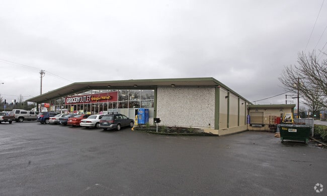

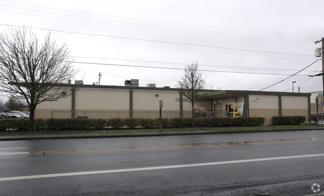
Property Detail
1510 E Portland Rd
56904
TOWNSHIP 3S RANGE 2W SECTION 20 QTR B QQTR A TAXLOT 00700
Commercialbuilding
YAMHILL
C-2
Oregon
B and X Area of moderate flood hazard, usually the area between the limits of the 100-year and 500-year floods.
1.47 AC
2025
Yamhill County
2025
Portland
030202
Portland-Vancouver-Hillsboro, OR-WA
NEARBY LISTINGS FOR SALE OR LEASE
DEMOGRAPHICS near 1510 E Portland Rd
1 mile
3 mile
5 mile
2025 Total Population
17,128
35,208
40,307
2030 Population
17,713
36,318
41,412
Pop Growth 2025-2030
+ 3.42%
+ 3.15%
+ 2.74%
Average Age
38
40
40
2025 Total Households
6,127
12,644
14,476
HH Growth 2025-2030
+ 3.66%
+ 3.43%
+ 3.03%
Median Household Inc
$82,710
$98,668
$102,329
Avg Household Size
2.50
2.60
2.60
2025 Avg HH Vehicles
2.00
2.00
2.00
Median Home Value
$442,073
$518,589
$567,932
Median Year Built
1987
1992
1991
Nearby Places
Map Layers
Map Styles
 Street
 Aerial
Layers
 Traffic
 Biking
Places
Listings with unknown addresses are not visible on the map
- Restaurants
- Banks
- Shops
- Fitness
- Groceries
PUBLIC TRANSPORTATION
AIRPORT
Portland International
Drive
Walk
Distance
Portland International
57 min
34.5 mi
Freight Ports
Port of Portland
Drive
Walk
Distance
Port of Portland
44 min
25.8 mi
Nearby Properties
Address
Land Use
TOTAL SIZE
Lot Size
Zoning
Address
Land Use
TOTAL SIZE
Lot Size
Zoning
Address
Land Use
TOTAL SIZE
Lot Size
Zoning
30.70 AC
SD/H
Address
Land Use
TOTAL SIZE
Lot Size
Zoning
4,630 SF
4.72 AC
R-2
Address
Land Use
TOTAL SIZE
Lot Size
Zoning
72 AC
R-1
Address
Land Use
TOTAL SIZE
Lot Size
Zoning
16.49 AC
I
Address
Land Use
TOTAL SIZE
Lot Size
Zoning
17.18 AC
C-2
Address
Land Use
TOTAL SIZE
Lot Size
Zoning
Address
Land Use
TOTAL SIZE
Lot Size
Zoning
3,020 SF
6.66 AC
I
Address
Land Use
TOTAL SIZE
Lot Size
Zoning
936 SF
7.67 AC
VLDR-1
Address
Land Use
TOTAL SIZE
Lot Size
Zoning
1,728 SF
6.39 AC
R-1
Address
Land Use
TOTAL SIZE
Lot Size
Zoning
16.84 AC
R-1
Address
Land Use
TOTAL SIZE
Lot Size
Zoning
4.96 AC
R-P/SP
Address
Land Use
TOTAL SIZE
Lot Size
Zoning
17.90 AC
M-1
Address
Land Use
TOTAL SIZE
Lot Size
Zoning
4.97 AC
R-P/SP
Address
Land Use
TOTAL SIZE
Lot Size
Zoning
3.65 AC
R-P/SP
Address
Land Use
TOTAL SIZE
Lot Size
Zoning
18.91 AC
M-1
Address
Land Use
TOTAL SIZE
Lot Size
Zoning
2,049 SF
3.21 AC
R-1
Address
Land Use
TOTAL SIZE
Lot Size
Zoning
9.96 AC
C-2
Address
Land Use
TOTAL SIZE
Lot Size
Zoning
14.21 AC
R-P/SP
Address
Land Use
TOTAL SIZE
Lot Size
Zoning
1.53 AC
R-P/SP
Address
Land Use
TOTAL SIZE
Lot Size
Zoning
2.99 AC
R-P/SP
Address
Land Use
TOTAL SIZE
Lot Size
Zoning
6.50 AC
M-1
Address
Land Use
TOTAL SIZE
Lot Size
Zoning
4.19 AC
C2
Address
Land Use
TOTAL SIZE
Lot Size
Zoning
Address
Land Use
TOTAL SIZE
Lot Size
Zoning
6.70 AC
I
Address
Land Use
TOTAL SIZE
Lot Size
Zoning
14.28 AC
R-2
Address
Land Use
TOTAL SIZE
Lot Size
Zoning
5.67 AC
M-2
Address
Land Use
TOTAL SIZE
Lot Size
Zoning
0.47 AC
I
Address
Land Use
TOTAL SIZE
Lot Size
Zoning
4,578 SF
38.05 AC
I
Address
Land Use
TOTAL SIZE
Lot Size
Zoning
12 AC
M-1
The World's #1 Commercial Real Estate Marketplace
Connect with us
© 2026 CoStar Group
The information above has been obtained from sources believed reliable. While we do not doubt its accuracy we have not verified it and make no guarantee, warranty or representation about it. It is your responsibility to independently confirm its accuracy and completeness. Any projections, opinions, assumptions, or estimates used are for example only and do not represent the current or future performance of the property. The value of this transaction to you depends on tax and other factors which should be evaluated by your tax, financial, and legal advisors. You and your advisors should conduct a careful, independent investigation of the property to determine to your satisfaction the suitability of the property for your needs.