Property Record
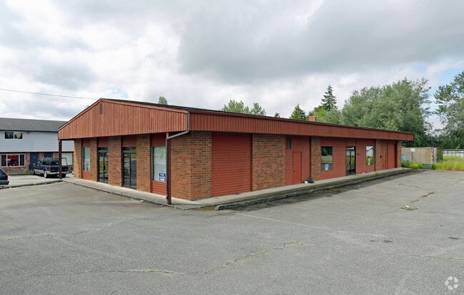
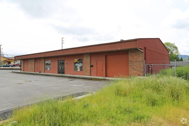
1510 N Laventure Rd, Mount Vernon, WA 98273

NEARBY LISTINGS FOR SALE OR LEASE
Property Detail
1510 N Laventure Rd
Mount Vernon-Anacortes, WA
Sd Sub
P24961
(4.8100 AC) TAX 37A W 3/4 OF NW1/4 SW1/4, SECTION 16, TOWNSHIP 34 NORTH, RANGE 4 EAST, W.M., EXC RD & EXC N 264FT OF TH PTN SD SUB LY S OF ST HWY 1-G EXC ADDITIONAL W 30FT FOR RD
Multifamilydwelling
Skagit
2025
Washington
2025
87 SF
952301
Bellingham/Northwest
18,176 SF
Other Market Areas
DEMOGRAPHICS near 1510 N Laventure Rd
1 Mile
3 Mile
5 Mile
2024 Total Population
15,323
47,269
61,174
2029 Population
16,009
49,408
63,818
Pop Growth 2024-2029
+ 4.48%
+ 4.53%
+ 4.32%
Average Age
38
40
40
2024 Total Households
5,418
17,386
22,569
HH Growth 2024-2029
+ 4.56%
+ 4.66%
+ 4.45%
Median Household Inc
$50,520
$61,782
$65,834
Avg Household Size
2.70
2.60
2.60
2024 Avg HH Vehicles
2.00
2.00
2.00
Median Home Value
$356,561
$401,813
$426,509
Median Year Built
1984
1987
1986
Nearby Places
Map Layers
Map Styles
 Street
 Aerial
- Restaurants
- Banks
- Shops
- Fitness
- Groceries
PUBLIC TRANSPORTATION
COMMUTER RAIL
Mount Vernon Amtrak Station (Amtrak Cascades - Amtrak)
DRIVE
WALK
Distance
Mount Vernon Amtrak Station (Amtrak Cascades - Amtrak)
6 min
2.5 mi
AIRPORT
Bellingham International
DRIVE
WALK
Distance
Bellingham International
43 min
32.5 mi
Freight Ports
Port of Anacortes
DRIVE
WALK
Distance
Port of Anacortes
32 min
19.1 mi
Nearby Properties
Address
Land Use
TOTAL SIZE
Lot Size
Zoning
Address
Land Use
TOTAL SIZE
Lot Size
Zoning
404,511 SF
9.01 AC
Address
Land Use
TOTAL SIZE
Lot Size
Zoning
16,345 SF
32.99 AC
Address
Land Use
TOTAL SIZE
Lot Size
Zoning
Address
Land Use
TOTAL SIZE
Lot Size
Zoning
1,500 SF
9.93 AC
Address
Land Use
TOTAL SIZE
Lot Size
Zoning
Address
Land Use
TOTAL SIZE
Lot Size
Zoning
129,102 SF
131 SF
Address
Land Use
TOTAL SIZE
Lot Size
Zoning
77,414 SF
15.20 AC
Address
Land Use
TOTAL SIZE
Lot Size
Zoning
212,480 SF
35.36 AC
Address
Land Use
TOTAL SIZE
Lot Size
Zoning
96,782 SF
4.50 AC
Address
Land Use
TOTAL SIZE
Lot Size
Zoning
200,145 SF
9.35 AC
Address
Land Use
TOTAL SIZE
Lot Size
Zoning
74,608 SF
87 SF
Address
Land Use
TOTAL SIZE
Lot Size
Zoning
Address
Land Use
TOTAL SIZE
Lot Size
Zoning
0.01 AC
Address
Land Use
TOTAL SIZE
Lot Size
Zoning
138,226 SF
30.55 AC
Address
Land Use
TOTAL SIZE
Lot Size
Zoning
2,468 SF
0.68 AC
Address
Land Use
TOTAL SIZE
Lot Size
Zoning
0.01 AC
Address
Land Use
TOTAL SIZE
Lot Size
Zoning
64,668 SF
0.29 AC
Address
Land Use
TOTAL SIZE
Lot Size
Zoning
114,589 SF
10.63 AC
Address
Land Use
TOTAL SIZE
Lot Size
Zoning
52,239 SF
5.50 AC
Address
Land Use
TOTAL SIZE
Lot Size
Zoning
0.01 AC
Address
Land Use
TOTAL SIZE
Lot Size
Zoning
138,353 SF
10 AC
Address
Land Use
TOTAL SIZE
Lot Size
Zoning
68,326 SF
5.29 AC
Address
Land Use
TOTAL SIZE
Lot Size
Zoning
75,744 SF
4 AC
Address
Land Use
TOTAL SIZE
Lot Size
Zoning
Address
Land Use
TOTAL SIZE
Lot Size
Zoning
74,419 SF
2.16 AC
Address
Land Use
TOTAL SIZE
Lot Size
Zoning
44,812 SF
6 AC
Address
Land Use
TOTAL SIZE
Lot Size
Zoning
55,326 SF
9.12 AC
Address
Land Use
TOTAL SIZE
Lot Size
Zoning
143,806 SF
5.50 AC
Address
Land Use
TOTAL SIZE
Lot Size
Zoning
93,720 SF
4.82 AC
Address
Land Use
TOTAL SIZE
Lot Size
Zoning
87,836 SF
7.12 AC
The World's #1 Commercial Real Estate Marketplace
Connect with us
© 2026 CoStar Group
The information above has been obtained from sources believed reliable. While we do not doubt its accuracy we have not verified it and make no guarantee, warranty or representation about it. It is your responsibility to independently confirm its accuracy and completeness. Any projections, opinions, assumptions, or estimates used are for example only and do not represent the current or future performance of the property. The value of this transaction to you depends on tax and other factors which should be evaluated by your tax, financial, and legal advisors. You and your advisors should conduct a careful, independent investigation of the property to determine to your satisfaction the suitability of the property for your needs.