Property Record
1510 Quail Lake Loop, Colorado Springs, CO 80906

NEARBY LISTINGS FOR SALE OR LEASE
Property Detail
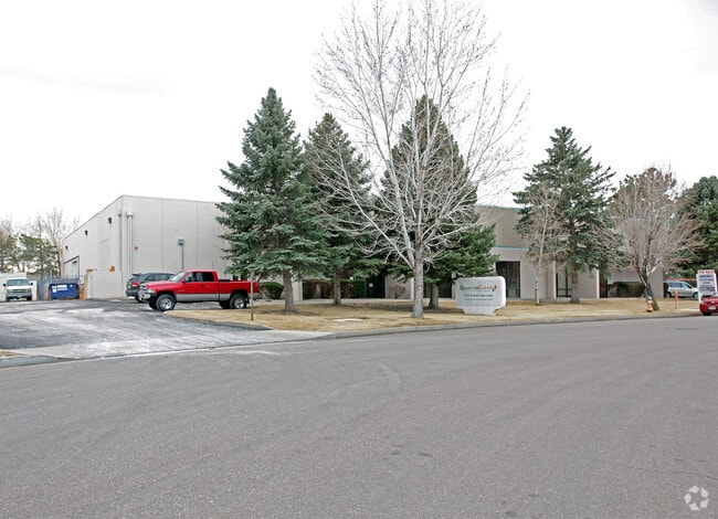
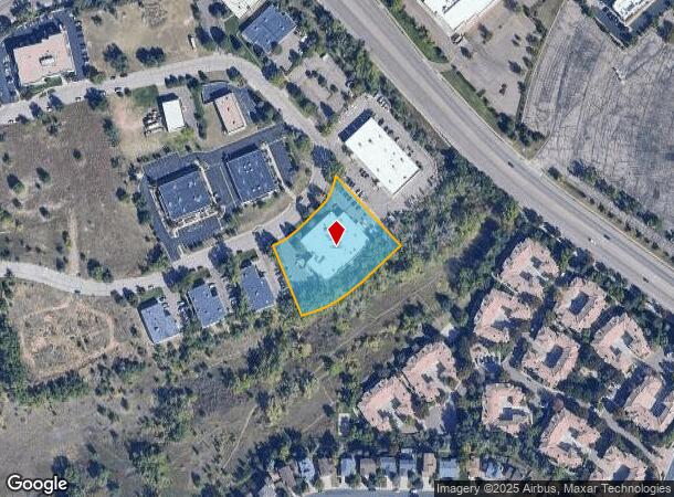
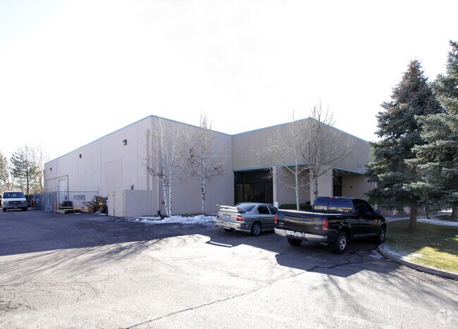
1510 Quail Lake Loop
Colorado Springs, CO
Quail Lake Business Center
64324-07-002
LOT 7 BLK 1 QUAIL LAKE BUSINESS CENTER COLO SPGS
Industrialgeneral
El Paso
X
Colorado
08041C0741G
7
2024
1.56 AC
2025
Southwest
003307
Colorado Springs
20,656 SF
DEMOGRAPHICS near 1510 Quail Lake Loop
1 Mile
3 Mile
5 Mile
2024 Total Population
8,563
90,068
217,041
2029 Population
8,862
94,399
227,044
Pop Growth 2024-2029
+ 3.49%
+ 4.81%
+ 4.61%
Average Age
41
36
36
2024 Total Households
3,884
35,385
84,343
HH Growth 2024-2029
+ 3.68%
+ 5.16%
+ 4.97%
Median Household Inc
$63,135
$58,504
$59,699
Avg Household Size
2.10
2.40
2.40
2024 Avg HH Vehicles
2.00
2.00
2.00
Median Home Value
$329,632
$348,743
$336,098
Median Year Built
1981
1980
1979
Nearby Places
Map Layers
Map Styles
 Street
 Aerial
- Restaurants
- Banks
- Shops
- Fitness
- Groceries
PUBLIC TRANSPORTATION
AIRPORT
City of Colorado Springs Municipal
DRIVE
WALK
Distance
City of Colorado Springs Municipal
22 min
10.1 mi
SALE & LEASE HISTORY
LISTING DATE
SALE/LEASE

Nov 16, 2020
For Lease
Nearby Properties
Address
Land Use
TOTAL SIZE
Lot Size
Zoning
Address
Land Use
TOTAL SIZE
Lot Size
Zoning
309,046 SF
28.95 AC
PF SS
Address
Land Use
TOTAL SIZE
Lot Size
Zoning
215,464 SF
11.59 AC
R-5
Address
Land Use
TOTAL SIZE
Lot Size
Zoning
152,977 SF
39.50 AC
MX-M MX-M/
Address
Land Use
TOTAL SIZE
Lot Size
Zoning
233,194 SF
30 AC
R-1 6 AO S
Address
Land Use
TOTAL SIZE
Lot Size
Zoning
226,707 SF
3.25 AC
PF UV
Address
Land Use
TOTAL SIZE
Lot Size
Zoning
168,835 SF
33 AC
PF SS
Address
Land Use
TOTAL SIZE
Lot Size
Zoning
215,377 SF
11.24 AC
R-5/CR
Address
Land Use
TOTAL SIZE
Lot Size
Zoning
983,639 SF
43.31 AC
MX-M CU HR
Address
Land Use
TOTAL SIZE
Lot Size
Zoning
109,739 SF
18.61 AC
BP/CR CU
Address
Land Use
TOTAL SIZE
Lot Size
Zoning
123,644 SF
74.14 AC
GI PF SS
Address
Land Use
TOTAL SIZE
Lot Size
Zoning
113,594 SF
1.65 AC
R-5 HR
Address
Land Use
TOTAL SIZE
Lot Size
Zoning
98,647 SF
9.50 AC
PDZ MX-N/C
Address
Land Use
TOTAL SIZE
Lot Size
Zoning
71,438 SF
9.81 AC
R-5/CR
Address
Land Use
TOTAL SIZE
Lot Size
Zoning
65,400 SF
13.65 AC
PF CU
Address
Land Use
TOTAL SIZE
Lot Size
Zoning
98,638 SF
7.22 AC
MX-M AO
Address
Land Use
TOTAL SIZE
Lot Size
Zoning
47,870 SF
0.72 AC
FBZ-COR SS
Address
Land Use
TOTAL SIZE
Lot Size
Zoning
601,737 SF
7.24 AC
MX-M
Address
Land Use
TOTAL SIZE
Lot Size
Zoning
23,535 SF
15.91 AC
BP/CR AO
Address
Land Use
TOTAL SIZE
Lot Size
Zoning
64,870 SF
0.92 AC
PDZ UV
Address
Land Use
TOTAL SIZE
Lot Size
Zoning
99,829 SF
15.39 AC
R-E CU UV
Address
Land Use
TOTAL SIZE
Lot Size
Zoning
226,448 SF
16.80 AC
MX-N/CR
Address
Land Use
TOTAL SIZE
Lot Size
Zoning
69,078 SF
0.03 AC
Address
Land Use
TOTAL SIZE
Lot Size
Zoning
107,146 SF
16.72 AC
R-1 6 CU
Address
Land Use
TOTAL SIZE
Lot Size
Zoning
58,598 SF
0.96 AC
PDZ UV
Address
Land Use
TOTAL SIZE
Lot Size
Zoning
124,107 SF
104.60 AC
MX-N CU
Address
Land Use
TOTAL SIZE
Lot Size
Zoning
166,182 SF
26.35 AC
BP/CR
Address
Land Use
TOTAL SIZE
Lot Size
Zoning
24,293 SF
10.61 AC
C5
Address
Land Use
TOTAL SIZE
Lot Size
Zoning
76,047 SF
5.74 AC
PF
Address
Land Use
TOTAL SIZE
Lot Size
Zoning
46,190 SF
4.02 AC
PDZ
Address
Land Use
TOTAL SIZE
Lot Size
Zoning
66,036 SF
6.70 AC
R-1 6 HS U
The World's #1 Commercial Real Estate Marketplace
Connect with us
© 2025 CoStar Group
The information above has been obtained from sources believed reliable. While we do not doubt its accuracy we have not verified it and make no guarantee, warranty or representation about it. It is your responsibility to independently confirm its accuracy and completeness. Any projections, opinions, assumptions, or estimates used are for example only and do not represent the current or future performance of the property. The value of this transaction to you depends on tax and other factors which should be evaluated by your tax, financial, and legal advisors. You and your advisors should conduct a careful, independent investigation of the property to determine to your satisfaction the suitability of the property for your needs.