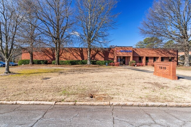
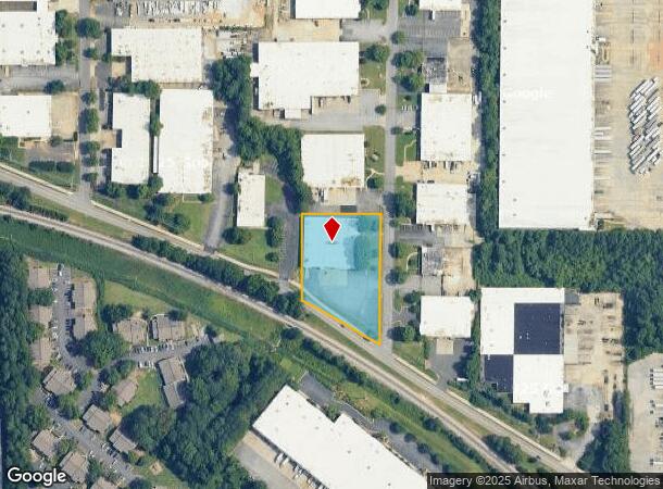
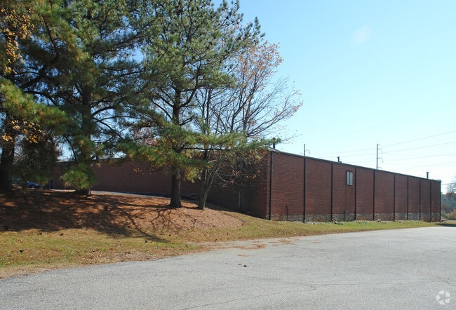
Property Record
1510 Stone Ridge Dr, Stone Mountain, GA 30083

Current Lease Availabilities
NEARBY LISTINGS FOR SALE OR LEASE
Property Detail
1510 Stone Ridge Dr
18-138-01-009
DeKalb
Warehouse
Georgia
X
9
13089C0079L
1.57 AC
2025
Stone Mountain
2025
Atlanta
021911
Atlanta-Sandy Springs-Roswell, GA
23,680 SF
DEMOGRAPHICS near 1510 Stone Ridge Dr
1 Mile
3 Mile
5 Mile
2024 Total Population
12,013
77,668
228,482
2029 Population
12,157
77,770
229,662
Pop Growth 2024-2029
+ 1.20%
+ 0.13%
+ 0.52%
Average Age
34
38
38
2024 Total Households
4,999
28,741
83,322
HH Growth 2024-2029
+ 1.18%
+ 0.11%
+ 0.45%
Median Household Inc
$34,828
$54,505
$62,628
Avg Household Size
2.30
2.60
2.70
2024 Avg HH Vehicles
1.00
2.00
2.00
Median Home Value
$172,222
$254,494
$279,836
Median Year Built
1979
1977
1979
Nearby Places
- Restaurants
- Banks
- Shops
- Fitness
- Groceries
PUBLIC TRANSPORTATION
AIRPORT
Hartsfield - Jackson Atlanta International
DRIVE
WALK
Distance
Hartsfield - Jackson Atlanta International
36 min
23.9 mi
Nearby Properties
Address
Land Use
TOTAL SIZE
Lot Size
Zoning
Address
Land Use
TOTAL SIZE
Lot Size
Zoning
656,837 SF
88.74 AC
RM100
Address
Land Use
TOTAL SIZE
Lot Size
Zoning
273,492 SF
23.08 AC
RM
Address
Land Use
TOTAL SIZE
Lot Size
Zoning
819,703 SF
55.80 AC
M
Address
Land Use
TOTAL SIZE
Lot Size
Zoning
587,493 SF
29.79 AC
X
Address
Land Use
TOTAL SIZE
Lot Size
Zoning
284,236 SF
22.25 AC
RM100
Address
Land Use
TOTAL SIZE
Lot Size
Zoning
89,362 SF
13.99 AC
M
Address
Land Use
TOTAL SIZE
Lot Size
Zoning
337,746 SF
29.94 AC
RM100
Address
Land Use
TOTAL SIZE
Lot Size
Zoning
170,933 SF
15.39 AC
X
Address
Land Use
TOTAL SIZE
Lot Size
Zoning
339,262 SF
26.16 AC
RM100
Address
Land Use
TOTAL SIZE
Lot Size
Zoning
224,812 SF
19.29 AC
RM75
Address
Land Use
TOTAL SIZE
Lot Size
Zoning
480,302 SF
34.46 AC
RM85
Address
Land Use
TOTAL SIZE
Lot Size
Zoning
358,818 SF
22.41 AC
RM100
Address
Land Use
TOTAL SIZE
Lot Size
Zoning
446,287 SF
31 AC
RM100
Address
Land Use
TOTAL SIZE
Lot Size
Zoning
299,798 SF
17.20 AC
X
Address
Land Use
TOTAL SIZE
Lot Size
Zoning
249,184 SF
20 AC
RM100
Address
Land Use
TOTAL SIZE
Lot Size
Zoning
240,276 SF
19.53 AC
RM85
Address
Land Use
TOTAL SIZE
Lot Size
Zoning
302,988 SF
41.36 AC
X
Address
Land Use
TOTAL SIZE
Lot Size
Zoning
292,996 SF
15.84 AC
RM100
Address
Land Use
TOTAL SIZE
Lot Size
Zoning
373,062 SF
20.59 AC
RM100
Address
Land Use
TOTAL SIZE
Lot Size
Zoning
324,116 SF
19.90 AC
A
Address
Land Use
TOTAL SIZE
Lot Size
Zoning
312,258 SF
24.80 AC
X
Address
Land Use
TOTAL SIZE
Lot Size
Zoning
384,545 SF
35.93 AC
RM100
Address
Land Use
TOTAL SIZE
Lot Size
Zoning
273,192 SF
24.07 AC
RM100
Address
Land Use
TOTAL SIZE
Lot Size
Zoning
189,486 SF
18.57 AC
X
Address
Land Use
TOTAL SIZE
Lot Size
Zoning
490,343 SF
28.70 AC
X
Address
Land Use
TOTAL SIZE
Lot Size
Zoning
124,868 SF
14.82 AC
Address
Land Use
TOTAL SIZE
Lot Size
Zoning
285,494 SF
19.35 AC
Address
Land Use
TOTAL SIZE
Lot Size
Zoning
495,922 SF
30.90 AC
RM100
Address
Land Use
TOTAL SIZE
Lot Size
Zoning
279,568 SF
0.15 AC
X
Address
Land Use
TOTAL SIZE
Lot Size
Zoning
330,474 SF
22.50 AC
RM100
The World's #1 Commercial Real Estate Marketplace
Connect with us
© 2025 CoStar Group
The information above has been obtained from sources believed reliable. While we do not doubt its accuracy we have not verified it and make no guarantee, warranty or representation about it. It is your responsibility to independently confirm its accuracy and completeness. Any projections, opinions, assumptions, or estimates used are for example only and do not represent the current or future performance of the property. The value of this transaction to you depends on tax and other factors which should be evaluated by your tax, financial, and legal advisors. You and your advisors should conduct a careful, independent investigation of the property to determine to your satisfaction the suitability of the property for your needs.