Property Record
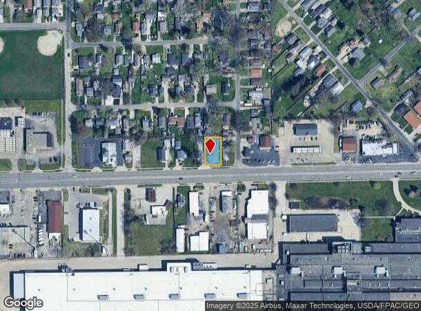
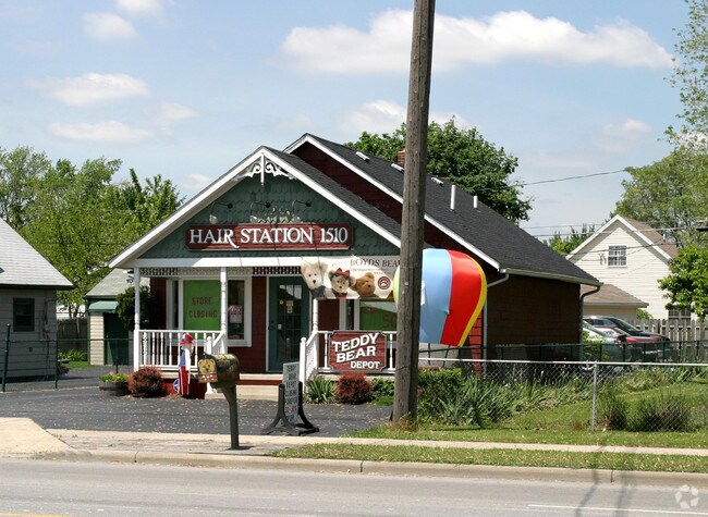
1510 W Alexis Rd, Toledo, OH 43612

NEARBY LISTINGS FOR SALE OR LEASE
Property Detail
1510 W Alexis Rd
Toledo, OH
Mclains Hopewell Hgts
23-38017
MCLAINS HOPEWELL HGTS LOT 5 W 30 FT & LOT 6
Storebuilding
Lucas
X
Ohio
39095C0077F
5,6
2024
0.10 AC
2024
North Toledo
005801
Toledo
850 SF
DEMOGRAPHICS near 1510 W Alexis Rd
1 Mile
3 Mile
5 Mile
2024 Total Population
9,534
82,383
179,797
2029 Population
9,573
81,247
178,532
Pop Growth 2024-2029
+ 0.41%
(1.38%)
(0.70%)
Average Age
39
39
39
2024 Total Households
4,337
35,164
76,025
HH Growth 2024-2029
+ 0.42%
(1.40%)
(0.76%)
Median Household Inc
$54,684
$55,864
$52,516
Avg Household Size
2.20
2.30
2.30
2024 Avg HH Vehicles
2.00
2.00
2.00
Median Home Value
$134,759
$124,082
$133,314
Median Year Built
1971
1957
1957
Nearby Places
Map Layers
Map Styles
 Street
 Aerial
- Restaurants
- Banks
- Shops
- Fitness
- Groceries
PUBLIC TRANSPORTATION
AIRPORT
Eugene F Kranz Toledo Express
DRIVE
WALK
Distance
Eugene F Kranz Toledo Express
42 min
24.1 mi
Detroit Metro Wayne County
DRIVE
WALK
Distance
Detroit Metro Wayne County
57 min
44.3 mi
Nearby Properties
Address
Land Use
TOTAL SIZE
Lot Size
Zoning
Address
Land Use
TOTAL SIZE
Lot Size
Zoning
1,972,579 SF
76.32 AC
10-IG
Address
Land Use
TOTAL SIZE
Lot Size
Zoning
693,900 SF
76.32 AC
10-IG
Address
Land Use
TOTAL SIZE
Lot Size
Zoning
448,269 SF
29.52 AC
10-IC
Address
Land Use
TOTAL SIZE
Lot Size
Zoning
249,216 SF
6.71 AC
10-IC
Address
Land Use
TOTAL SIZE
Lot Size
Zoning
253,662 SF
16.59 AC
10-MX
Address
Land Use
TOTAL SIZE
Lot Size
Zoning
76.32 AC
10-IG
Address
Land Use
TOTAL SIZE
Lot Size
Zoning
317,139 SF
25.80 AC
10-IC
Address
Land Use
TOTAL SIZE
Lot Size
Zoning
223,900 SF
17.26 AC
Address
Land Use
TOTAL SIZE
Lot Size
Zoning
163,962 SF
10.13 AC
Address
Land Use
TOTAL SIZE
Lot Size
Zoning
293,770 SF
13.95 AC
10-RS6
Address
Land Use
TOTAL SIZE
Lot Size
Zoning
90,113 SF
11.83 AC
10-RS6
Address
Land Use
TOTAL SIZE
Lot Size
Zoning
450,000 SF
37.30 AC
Address
Land Use
TOTAL SIZE
Lot Size
Zoning
18.70 AC
Address
Land Use
TOTAL SIZE
Lot Size
Zoning
222,493 SF
29.88 AC
10-IC
Address
Land Use
TOTAL SIZE
Lot Size
Zoning
154,003 SF
14 AC
10-MX
Address
Land Use
TOTAL SIZE
Lot Size
Zoning
61,718 SF
7 AC
Address
Land Use
TOTAL SIZE
Lot Size
Zoning
Address
Land Use
TOTAL SIZE
Lot Size
Zoning
47,600 SF
5.04 AC
Address
Land Use
TOTAL SIZE
Lot Size
Zoning
20.67 AC
10-MX
Address
Land Use
TOTAL SIZE
Lot Size
Zoning
170,528 SF
15 AC
Address
Land Use
TOTAL SIZE
Lot Size
Zoning
71,918 SF
7 AC
10-RS6
Address
Land Use
TOTAL SIZE
Lot Size
Zoning
328,898 SF
13.67 AC
10-IG
Address
Land Use
TOTAL SIZE
Lot Size
Zoning
302,338 SF
13.97 AC
Address
Land Use
TOTAL SIZE
Lot Size
Zoning
117,635 SF
5.30 AC
Address
Land Use
TOTAL SIZE
Lot Size
Zoning
90,507 SF
9 AC
10-CRSO
Address
Land Use
TOTAL SIZE
Lot Size
Zoning
75,127 SF
5.86 AC
Address
Land Use
TOTAL SIZE
Lot Size
Zoning
86,241 SF
8.70 AC
10-RS6
Address
Land Use
TOTAL SIZE
Lot Size
Zoning
22.97 AC
10-IG
Address
Land Use
TOTAL SIZE
Lot Size
Zoning
123,258 SF
23.59 AC
Address
Land Use
TOTAL SIZE
Lot Size
Zoning
86.45 AC
10-IG
The World's #1 Commercial Real Estate Marketplace
Connect with us
© 2025 CoStar Group
The information above has been obtained from sources believed reliable. While we do not doubt its accuracy we have not verified it and make no guarantee, warranty or representation about it. It is your responsibility to independently confirm its accuracy and completeness. Any projections, opinions, assumptions, or estimates used are for example only and do not represent the current or future performance of the property. The value of this transaction to you depends on tax and other factors which should be evaluated by your tax, financial, and legal advisors. You and your advisors should conduct a careful, independent investigation of the property to determine to your satisfaction the suitability of the property for your needs.