Property Record
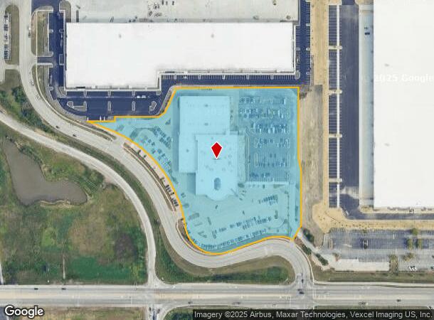
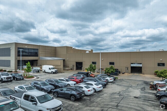
1510 W Dundee Rd, Arlington Heights, IL 60004

NEARBY LISTINGS FOR SALE OR LEASE
Property Detail
1510 W Dundee Rd
03-06-302-023-0000
Bob Rohrmans Arlington Heights Auto Mall
Parkingstructure
Cook
X
Illinois
17097C0244K
1&2
2023
9.38 AC
2025
Schaumburg Area
803012
Chicago
102,425 SF
Chicago-Naperville-Elgin, IL-IN-WI
DEMOGRAPHICS near 1510 W Dundee Rd
1 Mile
3 Mile
5 Mile
2024 Total Population
23,268
122,766
261,629
2029 Population
22,632
119,549
255,216
Pop Growth 2024-2029
(2.73%)
(2.62%)
(2.45%)
Average Age
37
42
42
2024 Total Households
8,878
47,752
101,102
HH Growth 2024-2029
(3.00%)
(2.94%)
(2.73%)
Median Household Inc
$66,109
$93,923
$102,223
Avg Household Size
2.60
2.50
2.50
2024 Avg HH Vehicles
2.00
2.00
2.00
Median Home Value
$254,307
$333,934
$356,686
Median Year Built
1979
1977
1977
Nearby Places
Map Layers
Map Styles
 Street
 Aerial
- Restaurants
- Banks
- Shops
- Fitness
- Groceries
PUBLIC TRANSPORTATION
COMMUTER RAIL
Arlington Park Station (Union Pacific Northwest Line - Northeast Illinois Regional Commuter Railroad (Metra))
DRIVE
WALK
Distance
Arlington Park Station (Union Pacific Northwest Line - Northeast Illinois Regional Commuter Railroad (Metra))
9 min
4.9 mi
Palatine Station (Union Pacific Northwest Line - Northeast Illinois Regional Commuter Railroad (Metra))
DRIVE
WALK
Distance
Palatine Station (Union Pacific Northwest Line - Northeast Illinois Regional Commuter Railroad (Metra))
11 min
5.3 mi
AIRPORT
Chicago O'Hare International
DRIVE
WALK
Distance
Chicago O'Hare International
28 min
19.8 mi
Chicago Midway International
DRIVE
WALK
Distance
Chicago Midway International
50 min
35.8 mi
Freight Ports
Port Milwaukee
DRIVE
WALK
Distance
Port Milwaukee
87 min
70.5 mi
Nearby Properties
Address
Land Use
TOTAL SIZE
Lot Size
Zoning
Address
Land Use
TOTAL SIZE
Lot Size
Zoning
11.24 AC
Address
Land Use
TOTAL SIZE
Lot Size
Zoning
622,896 SF
3.94 AC
Address
Land Use
TOTAL SIZE
Lot Size
Zoning
12.86 AC
Address
Land Use
TOTAL SIZE
Lot Size
Zoning
366,052 SF
32.18 AC
Address
Land Use
TOTAL SIZE
Lot Size
Zoning
Address
Land Use
TOTAL SIZE
Lot Size
Zoning
Address
Land Use
TOTAL SIZE
Lot Size
Zoning
Address
Land Use
TOTAL SIZE
Lot Size
Zoning
197,097 SF
21.80 AC
Address
Land Use
TOTAL SIZE
Lot Size
Zoning
295,685 SF
27.21 AC
Address
Land Use
TOTAL SIZE
Lot Size
Zoning
18.34 AC
Address
Land Use
TOTAL SIZE
Lot Size
Zoning
Address
Land Use
TOTAL SIZE
Lot Size
Zoning
214,428 SF
17.29 AC
Address
Land Use
TOTAL SIZE
Lot Size
Zoning
392,574 SF
25.82 AC
Address
Land Use
TOTAL SIZE
Lot Size
Zoning
Address
Land Use
TOTAL SIZE
Lot Size
Zoning
14,099 SF
2.01 AC
Address
Land Use
TOTAL SIZE
Lot Size
Zoning
493,632 SF
31.51 AC
Address
Land Use
TOTAL SIZE
Lot Size
Zoning
195,269 SF
11.07 AC
Address
Land Use
TOTAL SIZE
Lot Size
Zoning
49,539 SF
1.57 AC
Address
Land Use
TOTAL SIZE
Lot Size
Zoning
561,594 SF
29.88 AC
Address
Land Use
TOTAL SIZE
Lot Size
Zoning
Address
Land Use
TOTAL SIZE
Lot Size
Zoning
Address
Land Use
TOTAL SIZE
Lot Size
Zoning
Address
Land Use
TOTAL SIZE
Lot Size
Zoning
151,643 SF
11.18 AC
Address
Land Use
TOTAL SIZE
Lot Size
Zoning
Address
Land Use
TOTAL SIZE
Lot Size
Zoning
365,127 SF
16.31 AC
Address
Land Use
TOTAL SIZE
Lot Size
Zoning
399,179 SF
13.70 AC
Address
Land Use
TOTAL SIZE
Lot Size
Zoning
152,838 SF
10.05 AC
Address
Land Use
TOTAL SIZE
Lot Size
Zoning
Address
Land Use
TOTAL SIZE
Lot Size
Zoning
4,000 SF
1.41 AC
The World's #1 Commercial Real Estate Marketplace
Connect with us
© 2026 CoStar Group
The information above has been obtained from sources believed reliable. While we do not doubt its accuracy we have not verified it and make no guarantee, warranty or representation about it. It is your responsibility to independently confirm its accuracy and completeness. Any projections, opinions, assumptions, or estimates used are for example only and do not represent the current or future performance of the property. The value of this transaction to you depends on tax and other factors which should be evaluated by your tax, financial, and legal advisors. You and your advisors should conduct a careful, independent investigation of the property to determine to your satisfaction the suitability of the property for your needs.