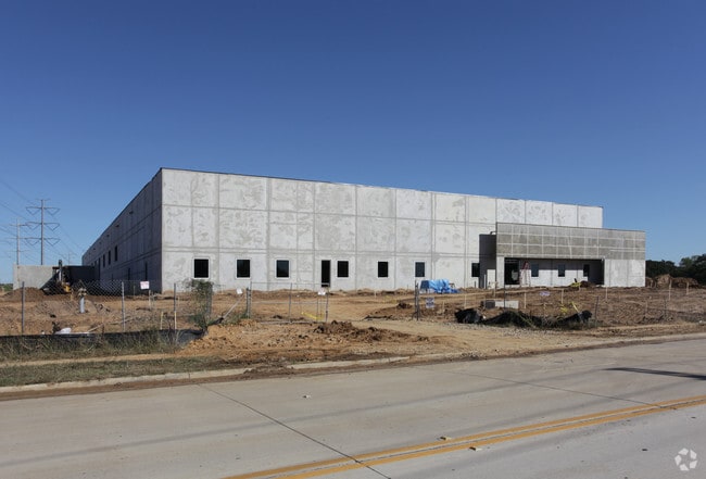
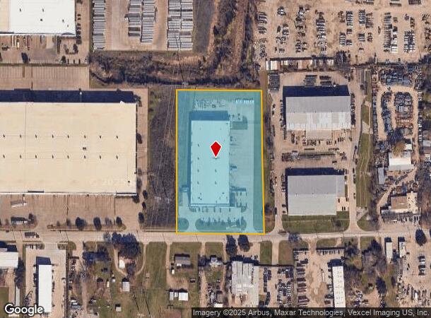
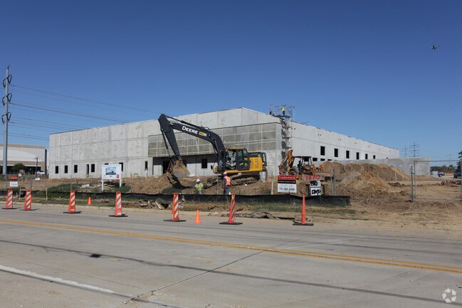
Property Record
1510 W Shady Grove Rd, Grand Prairie, TX 75050

NEARBY LISTINGS FOR SALE OR LEASE
Property Detail
1510 W Shady Grove Rd
Dallas-Fort Worth-Arlington, TX
Crosspoint Business Park Replat
28048200010040000
CROSSPOINT BUSINESS PARK REPLAT BLK 1 LT 4 ACS 6.113 INT202100326112 DD10272021 CO-DC 0482000100400 5CP04820001
Warehouse
Dallas
X
Texas
48439C0245L
4
2024
6.11 AC
2025
Upper Great Southwest
015303
Dallas/Ft Worth
70,771 SF
DEMOGRAPHICS near 1510 W Shady Grove Rd
1 Mile
3 Mile
5 Mile
2024 Total Population
1,995
68,513
265,083
2029 Population
1,982
69,127
268,600
Pop Growth 2024-2029
(0.65%)
+ 0.90%
+ 1.33%
Average Age
33
35
35
2024 Total Households
587
27,512
101,214
HH Growth 2024-2029
(0.68%)
+ 1.20%
+ 1.61%
Median Household Inc
$49,478
$57,646
$57,872
Avg Household Size
3.50
2.40
2.50
2024 Avg HH Vehicles
2.00
2.00
2.00
Median Home Value
$70,748
$241,116
$232,742
Median Year Built
1993
1986
1982
Nearby Places
Map Layers
Map Styles
 Street
 Aerial
- Restaurants
- Banks
- Shops
- Fitness
- Groceries
PUBLIC TRANSPORTATION
COMMUTER RAIL
DRIVE
WALK
Distance
3 min
1.5 mi
DRIVE
WALK
Distance
7 min
1.9 mi
AIRPORT
Dallas-Fort Worth International
DRIVE
WALK
Distance
Dallas-Fort Worth International
15 min
8.8 mi
Dallas Love Field
DRIVE
WALK
Distance
Dallas Love Field
24 min
15.0 mi
SALE & LEASE HISTORY
LISTING DATE
SALE/LEASE

Sep 24, 2016
For Sale
Nearby Properties
Address
Land Use
TOTAL SIZE
Lot Size
Zoning
Address
Land Use
TOTAL SIZE
Lot Size
Zoning
12,780,691 SF
0.08 AC
Z392
Address
Land Use
TOTAL SIZE
Lot Size
Zoning
3,204,300 SF
124.04 AC
Address
Land Use
TOTAL SIZE
Lot Size
Zoning
1,344,594 SF
44.86 AC
Address
Land Use
TOTAL SIZE
Lot Size
Zoning
1,447,078 SF
41.52 AC
Address
Land Use
TOTAL SIZE
Lot Size
Zoning
467,694 SF
24.03 AC
Address
Land Use
TOTAL SIZE
Lot Size
Zoning
332,952 SF
13.54 AC
Address
Land Use
TOTAL SIZE
Lot Size
Zoning
516,974 SF
23.81 AC
Address
Land Use
TOTAL SIZE
Lot Size
Zoning
485,911 SF
54.76 AC
Address
Land Use
TOTAL SIZE
Lot Size
Zoning
522,294 SF
18.35 AC
Address
Land Use
TOTAL SIZE
Lot Size
Zoning
703,500 SF
47.38 AC
Z236
Address
Land Use
TOTAL SIZE
Lot Size
Zoning
501,933 SF
16.25 AC
Address
Land Use
TOTAL SIZE
Lot Size
Zoning
422,880 SF
20.06 AC
Z177
Address
Land Use
TOTAL SIZE
Lot Size
Zoning
294,296 SF
12.08 AC
Address
Land Use
TOTAL SIZE
Lot Size
Zoning
738,276 SF
40.57 AC
Z243
Address
Land Use
TOTAL SIZE
Lot Size
Zoning
680,900 SF
32.25 AC
Z236
Address
Land Use
TOTAL SIZE
Lot Size
Zoning
683,300 SF
40.23 AC
Z01
Address
Land Use
TOTAL SIZE
Lot Size
Zoning
266,586 SF
11.47 AC
Address
Land Use
TOTAL SIZE
Lot Size
Zoning
342,583 SF
23.87 AC
Address
Land Use
TOTAL SIZE
Lot Size
Zoning
334,057 SF
20.05 AC
Z312
Address
Land Use
TOTAL SIZE
Lot Size
Zoning
339,965 SF
15.59 AC
Address
Land Use
TOTAL SIZE
Lot Size
Zoning
576,000 SF
55.36 AC
Z123
Address
Land Use
TOTAL SIZE
Lot Size
Zoning
151,552 SF
16 AC
Z58
Address
Land Use
TOTAL SIZE
Lot Size
Zoning
413,524 SF
24.70 AC
Z198
Address
Land Use
TOTAL SIZE
Lot Size
Zoning
285,194 SF
15.91 AC
Address
Land Use
TOTAL SIZE
Lot Size
Zoning
585,000 SF
27.06 AC
Z123
Address
Land Use
TOTAL SIZE
Lot Size
Zoning
520,000 SF
28.92 AC
Z123
Address
Land Use
TOTAL SIZE
Lot Size
Zoning
563,300 SF
27.40 AC
Z128
Address
Land Use
TOTAL SIZE
Lot Size
Zoning
253,710 SF
11.50 AC
Address
Land Use
TOTAL SIZE
Lot Size
Zoning
400,438 SF
35.92 AC
Address
Land Use
TOTAL SIZE
Lot Size
Zoning
500,256 SF
25.64 AC
Z123
The World's #1 Commercial Real Estate Marketplace
Connect with us
© 2025 CoStar Group
The information above has been obtained from sources believed reliable. While we do not doubt its accuracy we have not verified it and make no guarantee, warranty or representation about it. It is your responsibility to independently confirm its accuracy and completeness. Any projections, opinions, assumptions, or estimates used are for example only and do not represent the current or future performance of the property. The value of this transaction to you depends on tax and other factors which should be evaluated by your tax, financial, and legal advisors. You and your advisors should conduct a careful, independent investigation of the property to determine to your satisfaction the suitability of the property for your needs.