Property Record
15104 S Highway 50, Springfield, NE 68059
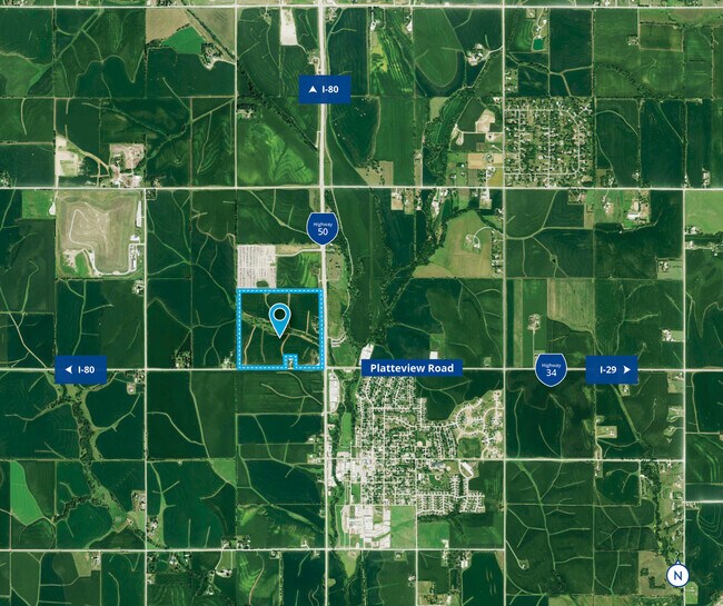

This Property Is For Sale
NEARBY LISTINGS FOR SALE OR LEASE
-
-
View all Springfield listings for sale on LoopNet.com
Property Detail
15104 S Highway 50
010460535
TAX LOTS 3 & 7 EXC ROW 14-13-11 (127.72 AC)
Agriculturalland
Sarpy
X
Nebraska
31025C0075D
3,7
2024
127.69 AC
2025
Southwest Omaha
010701
Omaha/Council Bluffs
2,202 SF
Omaha-Council Bluffs, NE-IA
DEMOGRAPHICS near 15104 S Highway 50
1 Mile
3 Mile
5 Mile
2024 Total Population
969
2,526
12,655
2029 Population
1,041
2,723
13,764
Pop Growth 2024-2029
+ 7.43%
+ 7.80%
+ 8.76%
Average Age
39
40
38
2024 Total Households
370
940
4,474
HH Growth 2024-2029
+ 7.57%
+ 7.98%
+ 8.99%
Median Household Inc
$80,743
$86,505
$121,669
Avg Household Size
2.60
2.60
2.80
2024 Avg HH Vehicles
2.00
2.00
2.00
Median Home Value
$252,525
$293,495
$394,136
Median Year Built
1973
1976
2003
Nearby Places
Map Layers
Map Styles
 Street
 Aerial
- Restaurants
- Banks
- Shops
- Fitness
- Groceries
PUBLIC TRANSPORTATION
AIRPORT
Eppley Airfield
DRIVE
WALK
Distance
Eppley Airfield
35 min
24.2 mi
Freight Ports
Tulsa Port Of Catoosa
DRIVE
WALK
Distance
Tulsa Port Of Catoosa
463 min
416.9 mi
Nearby Properties
Address
Land Use
TOTAL SIZE
Lot Size
Zoning
Address
Land Use
TOTAL SIZE
Lot Size
Zoning
181,712 SF
131.75 AC
Address
Land Use
TOTAL SIZE
Lot Size
Zoning
1,831 SF
173.14 AC
Address
Land Use
TOTAL SIZE
Lot Size
Zoning
51.65 AC
Address
Land Use
TOTAL SIZE
Lot Size
Zoning
334,533 SF
23.32 AC
Address
Land Use
TOTAL SIZE
Lot Size
Zoning
24,294 SF
25.79 AC
Address
Land Use
TOTAL SIZE
Lot Size
Zoning
183,184 SF
20.66 AC
Address
Land Use
TOTAL SIZE
Lot Size
Zoning
Address
Land Use
TOTAL SIZE
Lot Size
Zoning
17.75 AC
Address
Land Use
TOTAL SIZE
Lot Size
Zoning
9.76 AC
Address
Land Use
TOTAL SIZE
Lot Size
Zoning
2,125 SF
142.25 AC
Address
Land Use
TOTAL SIZE
Lot Size
Zoning
16.25 AC
Address
Land Use
TOTAL SIZE
Lot Size
Zoning
11.43 AC
Address
Land Use
TOTAL SIZE
Lot Size
Zoning
35,107 SF
13.15 AC
Address
Land Use
TOTAL SIZE
Lot Size
Zoning
11.40 AC
Address
Land Use
TOTAL SIZE
Lot Size
Zoning
Address
Land Use
TOTAL SIZE
Lot Size
Zoning
8.82 AC
Address
Land Use
TOTAL SIZE
Lot Size
Zoning
2,240 SF
60.20 AC
AG
Address
Land Use
TOTAL SIZE
Lot Size
Zoning
18,046 SF
6.94 AC
LI
Address
Land Use
TOTAL SIZE
Lot Size
Zoning
11,340 SF
35.46 AC
Address
Land Use
TOTAL SIZE
Lot Size
Zoning
116.77 AC
Address
Land Use
TOTAL SIZE
Lot Size
Zoning
15.10 AC
Address
Land Use
TOTAL SIZE
Lot Size
Zoning
2,866 SF
36.76 AC
Address
Land Use
TOTAL SIZE
Lot Size
Zoning
1.84 AC
Address
Land Use
TOTAL SIZE
Lot Size
Zoning
2.30 AC
Address
Land Use
TOTAL SIZE
Lot Size
Zoning
8.66 AC
Address
Land Use
TOTAL SIZE
Lot Size
Zoning
3,782 SF
314.41 AC
AG
Address
Land Use
TOTAL SIZE
Lot Size
Zoning
4,710 SF
185.15 AC
Address
Land Use
TOTAL SIZE
Lot Size
Zoning
39.96 AC
AG
Address
Land Use
TOTAL SIZE
Lot Size
Zoning
11,910 SF
1.63 AC
Address
Land Use
TOTAL SIZE
Lot Size
Zoning
17,565 SF
0.74 AC
The World's #1 Commercial Real Estate Marketplace
Connect with us
© 2025 CoStar Group
The information above has been obtained from sources believed reliable. While we do not doubt its accuracy we have not verified it and make no guarantee, warranty or representation about it. It is your responsibility to independently confirm its accuracy and completeness. Any projections, opinions, assumptions, or estimates used are for example only and do not represent the current or future performance of the property. The value of this transaction to you depends on tax and other factors which should be evaluated by your tax, financial, and legal advisors. You and your advisors should conduct a careful, independent investigation of the property to determine to your satisfaction the suitability of the property for your needs.