Property Record
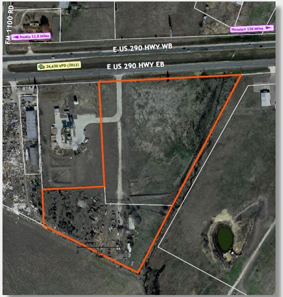
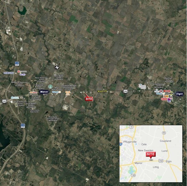
15105 Us Highway 290 E, Manor, TX 78653

Property Detail
15105 Us Highway 290 E
Austin-Round Rock-San Marcos, TX
ABS 154 SUR 52 CALDWELL A C ACR 10.143
724205
TRAVIS
Commercialnec
Texas
A Areas with a 1% annual chance of flooding and a 26% chance of flooding over the life of a 30-year mortgage.
10.14 AC
2025
East
2025
Austin
002217
NEARBY LISTINGS FOR SALE OR LEASE
DEMOGRAPHICS near 15105 Us Highway 290 E
1 mile
3 mile
5 mile
2025 Total Population
811
16,927
39,005
2030 Population
892
18,074
41,982
Pop Growth 2025-2030
+ 9.99%
+ 6.78%
+ 7.63%
Average Age
36
35
36
2025 Total Households
254
5,243
12,271
HH Growth 2025-2030
+ 10.63%
+ 7.44%
+ 8.39%
Median Household Inc
$91,562
$94,739
$92,249
Avg Household Size
3.20
3.20
3.20
2025 Avg HH Vehicles
2.00
2.00
2.00
Median Home Value
$264,285
$341,262
$347,970
Median Year Built
2010
2011
2010
Nearby Places
Map Layers
Map Styles
 Street
 Aerial
Layers
 Traffic
 Biking
Places
Listings with unknown addresses are not visible on the map
- Restaurants
- Banks
- Shops
- Fitness
- Groceries
PUBLIC TRANSPORTATION
AIRPORT
Austin-Bergstrom International
Drive
Walk
Distance
Austin-Bergstrom International
34 min
23.0 mi
Freight Ports
Calhoun Port
Drive
Walk
Distance
Calhoun Port
195 min
166.0 mi
SALE & LEASE HISTORY
LISTING DATE
SALE/LEASE

Sep 24, 2016
For Sale
Mar 31, 2017
For Sale
Nearby Properties
Address
Land Use
TOTAL SIZE
Lot Size
Zoning
Address
Land Use
TOTAL SIZE
Lot Size
Zoning
264,000 SF
14.22 AC
Address
Land Use
TOTAL SIZE
Lot Size
Zoning
109,184 SF
13.45 AC
Address
Land Use
TOTAL SIZE
Lot Size
Zoning
7,130 SF
20.44 AC
Address
Land Use
TOTAL SIZE
Lot Size
Zoning
236.07 AC
Address
Land Use
TOTAL SIZE
Lot Size
Zoning
100,100 SF
8.52 AC
Address
Land Use
TOTAL SIZE
Lot Size
Zoning
52,500 SF
5.47 AC
Address
Land Use
TOTAL SIZE
Lot Size
Zoning
60,210 SF
5.09 AC
Address
Land Use
TOTAL SIZE
Lot Size
Zoning
49,372 SF
6.32 AC
Address
Land Use
TOTAL SIZE
Lot Size
Zoning
23,551 SF
10.01 AC
Address
Land Use
TOTAL SIZE
Lot Size
Zoning
29,918 SF
11.56 AC
Address
Land Use
TOTAL SIZE
Lot Size
Zoning
114.84 AC
Address
Land Use
TOTAL SIZE
Lot Size
Zoning
12.84 AC
Address
Land Use
TOTAL SIZE
Lot Size
Zoning
110.92 AC
Address
Land Use
TOTAL SIZE
Lot Size
Zoning
2,112 SF
20.24 AC
Address
Land Use
TOTAL SIZE
Lot Size
Zoning
1 SF
97 AC
Address
Land Use
TOTAL SIZE
Lot Size
Zoning
98.29 AC
Address
Land Use
TOTAL SIZE
Lot Size
Zoning
1,632 SF
11.23 AC
Address
Land Use
TOTAL SIZE
Lot Size
Zoning
560 SF
52.72 AC
Address
Land Use
TOTAL SIZE
Lot Size
Zoning
11,960 SF
10.95 AC
Address
Land Use
TOTAL SIZE
Lot Size
Zoning
3,840 SF
15.71 AC
Address
Land Use
TOTAL SIZE
Lot Size
Zoning
27,120 SF
2.01 AC
Address
Land Use
TOTAL SIZE
Lot Size
Zoning
10 AC
Address
Land Use
TOTAL SIZE
Lot Size
Zoning
3,801 SF
8.99 AC
Address
Land Use
TOTAL SIZE
Lot Size
Zoning
4,950 SF
77.84 AC
Address
Land Use
TOTAL SIZE
Lot Size
Zoning
92.45 AC
Address
Land Use
TOTAL SIZE
Lot Size
Zoning
6,330 SF
1.38 AC
Address
Land Use
TOTAL SIZE
Lot Size
Zoning
21,044 SF
7.02 AC
Address
Land Use
TOTAL SIZE
Lot Size
Zoning
1,908 SF
59.10 AC
Address
Land Use
TOTAL SIZE
Lot Size
Zoning
9,574 SF
4.08 AC
Address
Land Use
TOTAL SIZE
Lot Size
Zoning
6,720 SF
1.88 AC
The World's #1 Commercial Real Estate Marketplace
Connect with us
© 2026 CoStar Group
The information above has been obtained from sources believed reliable. While we do not doubt its accuracy we have not verified it and make no guarantee, warranty or representation about it. It is your responsibility to independently confirm its accuracy and completeness. Any projections, opinions, assumptions, or estimates used are for example only and do not represent the current or future performance of the property. The value of this transaction to you depends on tax and other factors which should be evaluated by your tax, financial, and legal advisors. You and your advisors should conduct a careful, independent investigation of the property to determine to your satisfaction the suitability of the property for your needs.