Property Record
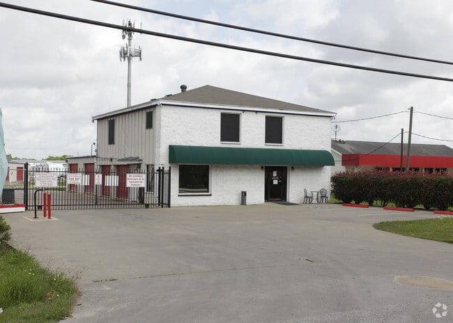
1511 County Road 129, Pearland, TX 77581


NEARBY LISTINGS FOR SALE OR LEASE
Property Detail
1511 County Road 129
0370-0005-000
W H Snyder
Commercialnec
A0370 W H SNYDER TRACT 1F-1F1 ACRES 4.05
X
Brazoria
48039C0065K
Texas
2024
4.05 AC
2025
NASA/Clear Lake
6602002
Houston
25,425 SF
Houston-The Woodlands-Sugar Land, TX
DEMOGRAPHICS near 1511 County Road 129
1 Mile
3 Mile
5 Mile
2024 Total Population
2,635
47,225
143,039
2029 Population
2,766
49,716
150,131
Pop Growth 2024-2029
+ 4.97%
+ 5.27%
+ 4.96%
Average Age
42
40
38
2024 Total Households
933
16,548
48,362
HH Growth 2024-2029
+ 5.14%
+ 5.44%
+ 5.03%
Median Household Inc
$105,570
$114,653
$102,228
Avg Household Size
2.70
2.80
2.90
2024 Avg HH Vehicles
2.00
2.00
2.00
Median Home Value
$360,820
$307,521
$282,313
Median Year Built
1988
1989
1995
Nearby Places
Map Layers
Map Styles
 Street
 Aerial
- Restaurants
- Banks
- Shops
- Fitness
- Groceries
PUBLIC TRANSPORTATION
AIRPORT
William P Hobby
DRIVE
WALK
Distance
William P Hobby
24 min
12.6 mi
Freight Ports
Port of Houston
DRIVE
WALK
Distance
Port of Houston
34 min
21.5 mi
Nearby Properties
Address
Land Use
TOTAL SIZE
Lot Size
Zoning
Address
Land Use
TOTAL SIZE
Lot Size
Zoning
40.52 AC
0017
Address
Land Use
TOTAL SIZE
Lot Size
Zoning
83.37 AC
0004
Address
Land Use
TOTAL SIZE
Lot Size
Zoning
142,155 SF
19.16 AC
SP
Address
Land Use
TOTAL SIZE
Lot Size
Zoning
65,935 SF
81.27 AC
Address
Land Use
TOTAL SIZE
Lot Size
Zoning
161,803 SF
54.82 AC
Address
Land Use
TOTAL SIZE
Lot Size
Zoning
107,600 SF
3.73 AC
Address
Land Use
TOTAL SIZE
Lot Size
Zoning
130,563 SF
13.23 AC
CSC
Address
Land Use
TOTAL SIZE
Lot Size
Zoning
84,272 SF
16.93 AC
Address
Land Use
TOTAL SIZE
Lot Size
Zoning
113,376 SF
9.80 AC
Address
Land Use
TOTAL SIZE
Lot Size
Zoning
49,444 SF
7.23 AC
Address
Land Use
TOTAL SIZE
Lot Size
Zoning
111,642 SF
9.53 AC
Address
Land Use
TOTAL SIZE
Lot Size
Zoning
115,805 SF
10.12 AC
SP
Address
Land Use
TOTAL SIZE
Lot Size
Zoning
99,042 SF
13 AC
MFRM
Address
Land Use
TOTAL SIZE
Lot Size
Zoning
229,097 SF
22.66 AC
Address
Land Use
TOTAL SIZE
Lot Size
Zoning
138,839 SF
7.46 AC
MFRH
Address
Land Use
TOTAL SIZE
Lot Size
Zoning
68,894 SF
6.11 AC
Address
Land Use
TOTAL SIZE
Lot Size
Zoning
83,995 SF
21.74 AC
CSC
Address
Land Use
TOTAL SIZE
Lot Size
Zoning
54,802 SF
12.63 AC
0014
Address
Land Use
TOTAL SIZE
Lot Size
Zoning
6,948 SF
54.94 AC
2080
Address
Land Use
TOTAL SIZE
Lot Size
Zoning
63,377 SF
2.71 AC
OBD
Address
Land Use
TOTAL SIZE
Lot Size
Zoning
76,646 SF
11.39 AC
SP
Address
Land Use
TOTAL SIZE
Lot Size
Zoning
110,923 SF
6.97 AC
Address
Land Use
TOTAL SIZE
Lot Size
Zoning
112,720 SF
8.21 AC
Address
Land Use
TOTAL SIZE
Lot Size
Zoning
108,250 SF
9.89 AC
Address
Land Use
TOTAL SIZE
Lot Size
Zoning
67,997 SF
3.98 AC
OBD
Address
Land Use
TOTAL SIZE
Lot Size
Zoning
77,997 SF
19 AC
0065
Address
Land Use
TOTAL SIZE
Lot Size
Zoning
56,905 SF
7 AC
Address
Land Use
TOTAL SIZE
Lot Size
Zoning
Address
Land Use
TOTAL SIZE
Lot Size
Zoning
3,680 SF
3.35 AC
OBD
Address
Land Use
TOTAL SIZE
Lot Size
Zoning
78,876 SF
9.22 AC
The World's #1 Commercial Real Estate Marketplace
Connect with us
© 2025 CoStar Group
The information above has been obtained from sources believed reliable. While we do not doubt its accuracy we have not verified it and make no guarantee, warranty or representation about it. It is your responsibility to independently confirm its accuracy and completeness. Any projections, opinions, assumptions, or estimates used are for example only and do not represent the current or future performance of the property. The value of this transaction to you depends on tax and other factors which should be evaluated by your tax, financial, and legal advisors. You and your advisors should conduct a careful, independent investigation of the property to determine to your satisfaction the suitability of the property for your needs.