Property Record
1511 E State St, Olean, NY 14760
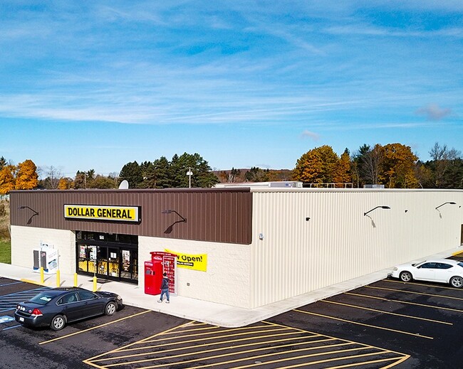

Property Detail
1511 E State St
Olean, NY
CATTARAUGUS
041200 94.075-4-10.2
New York
Storebuilding
10.002
2025
1.45 AC
2025
New York West Area
961800
Other Market Areas
9,100 SF
NEARBY LISTINGS FOR SALE OR LEASE
DEMOGRAPHICS near 1511 E State St
1 mile
3 mile
5 mile
2025 Total Population
2,555
15,467
21,341
2030 Population
2,517
15,146
20,913
Pop Growth 2025-2030
(1.49%)
(2.08%)
(2.01%)
Average Age
43
42
41
2025 Total Households
1,164
6,892
8,929
HH Growth 2025-2030
(1.55%)
(2.21%)
(2.24%)
Median Household Inc
$60,638
$45,667
$48,338
Avg Household Size
2.10
2.10
2.10
2025 Avg HH Vehicles
1.00
1.00
2.00
Median Home Value
$116,557
$87,561
$96,882
Median Year Built
1954
1947
1948
Nearby Places
Map Layers
Map Styles
 Street
 Aerial
Transit
 Traffic
 Biking
Places
Listings with unknown addresses are not visible on the map
- Restaurants
- Banks
- Shops
- Fitness
- Groceries
SALE & LEASE HISTORY
LISTING DATE
SALE/LEASE

Nov 19, 2018
For Sale
Nov 16, 2018
For Sale
Nearby Properties
Address
Land Use
TOTAL SIZE
Lot Size
Zoning
Address
Land Use
TOTAL SIZE
Lot Size
Zoning
116,203 SF
9.07 AC
R3
Address
Land Use
TOTAL SIZE
Lot Size
Zoning
159,609 SF
29.60 AC
R3
Address
Land Use
TOTAL SIZE
Lot Size
Zoning
32,878 SF
11.10 AC
CC
Address
Land Use
TOTAL SIZE
Lot Size
Zoning
26,777 SF
9.65 AC
WC
Address
Land Use
TOTAL SIZE
Lot Size
Zoning
26,250 SF
16.65 AC
I2
Address
Land Use
TOTAL SIZE
Lot Size
Zoning
8,944 SF
4.55 AC
R3
Address
Land Use
TOTAL SIZE
Lot Size
Zoning
23 AC
Address
Land Use
TOTAL SIZE
Lot Size
Zoning
Address
Land Use
TOTAL SIZE
Lot Size
Zoning
2,816 SF
Address
Land Use
TOTAL SIZE
Lot Size
Zoning
Address
Land Use
TOTAL SIZE
Lot Size
Zoning
6,889 SF
88.10 AC
I
Address
Land Use
TOTAL SIZE
Lot Size
Zoning
104,870 SF
8 AC
AR
Address
Land Use
TOTAL SIZE
Lot Size
Zoning
323,724 SF
25.25 AC
CON
Address
Land Use
TOTAL SIZE
Lot Size
Zoning
117,634 SF
2.30 AC
GC
Address
Land Use
TOTAL SIZE
Lot Size
Zoning
60,287 SF
10.62 AC
GC
Address
Land Use
TOTAL SIZE
Lot Size
Zoning
90,875 SF
12 AC
I2
Address
Land Use
TOTAL SIZE
Lot Size
Zoning
106.40 AC
R1
Address
Land Use
TOTAL SIZE
Lot Size
Zoning
67,513 SF
3.93 AC
Address
Land Use
TOTAL SIZE
Lot Size
Zoning
61,850 SF
2.39 AC
Address
Land Use
TOTAL SIZE
Lot Size
Zoning
64,924 SF
2.57 AC
Address
Land Use
TOTAL SIZE
Lot Size
Zoning
23,326 SF
1.14 AC
CC
Address
Land Use
TOTAL SIZE
Lot Size
Zoning
35,546 SF
1.80 AC
R3
Address
Land Use
TOTAL SIZE
Lot Size
Zoning
58,680 SF
5.40 AC
GC
Address
Land Use
TOTAL SIZE
Lot Size
Zoning
38,753 SF
18.41 AC
R3
Address
Land Use
TOTAL SIZE
Lot Size
Zoning
23.75 AC
AR
Address
Land Use
TOTAL SIZE
Lot Size
Zoning
27,842 SF
0.84 AC
CC
Address
Land Use
TOTAL SIZE
Lot Size
Zoning
41,340 SF
2 AC
Address
Land Use
TOTAL SIZE
Lot Size
Zoning
10,350 SF
1.75 AC
GC
Address
Land Use
TOTAL SIZE
Lot Size
Zoning
79,396 SF
1.90 AC
GC
Address
Land Use
TOTAL SIZE
Lot Size
Zoning
66,213 SF
0.24 AC
CC
The World's #1 Commercial Real Estate Marketplace
Connect with us
© 2026 CoStar Group
The information above has been obtained from sources believed reliable. While we do not doubt its accuracy we have not verified it and make no guarantee, warranty or representation about it. It is your responsibility to independently confirm its accuracy and completeness. Any projections, opinions, assumptions, or estimates used are for example only and do not represent the current or future performance of the property. The value of this transaction to you depends on tax and other factors which should be evaluated by your tax, financial, and legal advisors. You and your advisors should conduct a careful, independent investigation of the property to determine to your satisfaction the suitability of the property for your needs.