Property Record
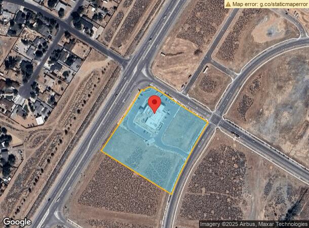
1511 Oppio Ranch Pkwy, Sparks, NV 89436
NEARBY LISTINGS FOR SALE OR LEASE
Property Detail
1511 Oppio Ranch Pkwy
528-611-01
_Unspecified
Commercialnec
PM 5481 PAR F-1
X
Washoe
32031C2865G
Nevada
2025
5 AC
2026
Spanish Springs
003520
Reno/Sparks
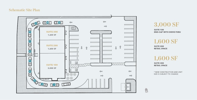
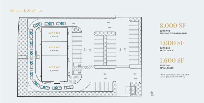
11,061 SF
Reno, NV
DEMOGRAPHICS near 1511 Oppio Ranch Pkwy
1 Mile
3 Mile
5 Mile
2024 Total Population
5,428
45,334
85,314
2029 Population
5,814
47,981
90,007
Pop Growth 2024-2029
+ 7.11%
+ 5.84%
+ 5.50%
Average Age
42
40
40
2024 Total Households
1,983
16,319
29,955
HH Growth 2024-2029
+ 7.06%
+ 5.96%
+ 5.65%
Median Household Inc
$96,882
$105,769
$98,042
Avg Household Size
2.70
2.80
2.80
2024 Avg HH Vehicles
2.00
2.00
2.00
Median Home Value
$423,101
$461,348
$443,906
Median Year Built
2000
2003
2000
Nearby Places
Map Layers
Map Styles
 Street
 Aerial
- Restaurants
- Banks
- Shops
- Fitness
- Groceries
PUBLIC TRANSPORTATION
AIRPORT
Reno/Tahoe International
DRIVE
WALK
Distance
Reno/Tahoe International
37 min
15.0 mi
SALE & LEASE HISTORY
LISTING DATE
SALE/LEASE

Aug 05, 2022
For Lease
Nearby Properties
Address
Land Use
TOTAL SIZE
Lot Size
Zoning
Address
Land Use
TOTAL SIZE
Lot Size
Zoning
406,338 SF
15.07 AC
NUD
Address
Land Use
TOTAL SIZE
Lot Size
Zoning
416,482 SF
21.84 AC
PD
Address
Land Use
TOTAL SIZE
Lot Size
Zoning
333,867 SF
14.71 AC
NUD
Address
Land Use
TOTAL SIZE
Lot Size
Zoning
271,111 SF
31.84 AC
NUD
Address
Land Use
TOTAL SIZE
Lot Size
Zoning
308,431 SF
20 AC
PD
Address
Land Use
TOTAL SIZE
Lot Size
Zoning
236,695 SF
8.66 AC
PD
Address
Land Use
TOTAL SIZE
Lot Size
Zoning
289,637 SF
53.48 AC
PSP
Address
Land Use
TOTAL SIZE
Lot Size
Zoning
238,764 SF
7 AC
NC
Address
Land Use
TOTAL SIZE
Lot Size
Zoning
231,353 SF
11.52 AC
NUD
Address
Land Use
TOTAL SIZE
Lot Size
Zoning
188,281 SF
641.92 AC
OS 88% / G
Address
Land Use
TOTAL SIZE
Lot Size
Zoning
209,527 SF
5.28 AC
NC
Address
Land Use
TOTAL SIZE
Lot Size
Zoning
160,562 SF
17.10 AC
I
Address
Land Use
TOTAL SIZE
Lot Size
Zoning
181,857 SF
8.19 AC
NUD
Address
Land Use
TOTAL SIZE
Lot Size
Zoning
412,614 SF
25.93 AC
I
Address
Land Use
TOTAL SIZE
Lot Size
Zoning
197,364 SF
11.34 AC
NUD
Address
Land Use
TOTAL SIZE
Lot Size
Zoning
186,572 SF
12.17 AC
NUD
Address
Land Use
TOTAL SIZE
Lot Size
Zoning
408,660 SF
20.15 AC
I
Address
Land Use
TOTAL SIZE
Lot Size
Zoning
74,637 SF
6.04 AC
NUD
Address
Land Use
TOTAL SIZE
Lot Size
Zoning
70,030 SF
36.71 AC
PSP
Address
Land Use
TOTAL SIZE
Lot Size
Zoning
146,900 SF
10 AC
I
Address
Land Use
TOTAL SIZE
Lot Size
Zoning
55,704 SF
14.03 AC
MDS 1% / O
Address
Land Use
TOTAL SIZE
Lot Size
Zoning
112,215 SF
5.49 AC
NUD
Address
Land Use
TOTAL SIZE
Lot Size
Zoning
122,223 SF
20 AC
PSP
Address
Land Use
TOTAL SIZE
Lot Size
Zoning
152,640 SF
24.48 AC
I
Address
Land Use
TOTAL SIZE
Lot Size
Zoning
137,236 SF
10.02 AC
PD
Address
Land Use
TOTAL SIZE
Lot Size
Zoning
57,702 SF
5.27 AC
PD
Address
Land Use
TOTAL SIZE
Lot Size
Zoning
81,122 SF
8.44 AC
NUD
Address
Land Use
TOTAL SIZE
Lot Size
Zoning
35.59 AC
NUD
Address
Land Use
TOTAL SIZE
Lot Size
Zoning
40.56 AC
NUD
Address
Land Use
TOTAL SIZE
Lot Size
Zoning
58,299 SF
6.75 AC
PD
The World's #1 Commercial Real Estate Marketplace
Connect with us
© 2026 CoStar Group
The information above has been obtained from sources believed reliable. While we do not doubt its accuracy we have not verified it and make no guarantee, warranty or representation about it. It is your responsibility to independently confirm its accuracy and completeness. Any projections, opinions, assumptions, or estimates used are for example only and do not represent the current or future performance of the property. The value of this transaction to you depends on tax and other factors which should be evaluated by your tax, financial, and legal advisors. You and your advisors should conduct a careful, independent investigation of the property to determine to your satisfaction the suitability of the property for your needs.