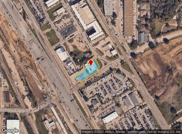
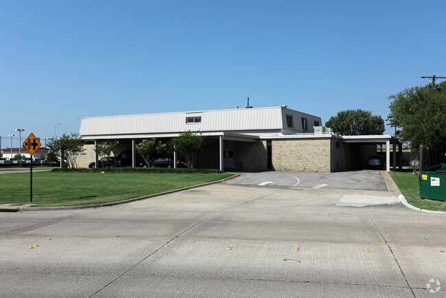
Property Record
1511 S Interstate 35E, Carrollton, TX 75006

NEARBY LISTINGS FOR SALE OR LEASE
Property Detail
1511 S Interstate 35E
Dallas-Fort Worth-Arlington, TX
Carrollton Annex
14008500020080000
CARROLLTON ANNEX BLK B LTS 7 & 8 & ADJ LAND ACS 0.793 VOL97012/1748 DD010197 CO-DALLAS 0085000200800 11400850002
Funeralhome
Dallas
X
Texas
48113C0160K
7,8
2024
0.79 AC
2025
South Carrollton
013729
Dallas/Ft Worth
13,220 SF
DEMOGRAPHICS near 1511 S Interstate 35E
1 Mile
3 Mile
5 Mile
2024 Total Population
10,275
81,609
294,263
2029 Population
10,326
81,553
308,183
Pop Growth 2024-2029
+ 0.50%
(0.07%)
+ 4.73%
Average Age
35
38
37
2024 Total Households
3,448
30,883
119,793
HH Growth 2024-2029
+ 0.84%
0.00%
+ 4.82%
Median Household Inc
$68,363
$76,455
$83,865
Avg Household Size
2.90
2.60
2.40
2024 Avg HH Vehicles
2.00
2.00
2.00
Median Home Value
$223,578
$285,576
$342,421
Median Year Built
1974
1982
1988
Nearby Places
Map Layers
Map Styles
 Street
 Aerial
- Restaurants
- Banks
- Shops
- Fitness
- Groceries
PUBLIC TRANSPORTATION
COMMUTER RAIL
Trinity Mills Station (Green Line - Dallas Area Rapid Transit (DART))
DRIVE
WALK
Distance
Trinity Mills Station (Green Line - Dallas Area Rapid Transit (DART))
5 min
2.9 mi
DRIVE
WALK
Distance
11 min
6.8 mi
AIRPORT
Dallas Love Field
DRIVE
WALK
Distance
Dallas Love Field
20 min
12.1 mi
Dallas-Fort Worth International
DRIVE
WALK
Distance
Dallas-Fort Worth International
21 min
15.8 mi
Nearby Properties
Address
Land Use
TOTAL SIZE
Lot Size
Zoning
Address
Land Use
TOTAL SIZE
Lot Size
Zoning
655,587 SF
8.02 AC
Address
Land Use
TOTAL SIZE
Lot Size
Zoning
605,278 SF
10.70 AC
Z236
Address
Land Use
TOTAL SIZE
Lot Size
Zoning
513,871 SF
3.63 AC
Z235
Address
Land Use
TOTAL SIZE
Lot Size
Zoning
368,845 SF
20.96 AC
Z172
Address
Land Use
TOTAL SIZE
Lot Size
Zoning
544,650 SF
26.03 AC
Z177
Address
Land Use
TOTAL SIZE
Lot Size
Zoning
544,163 SF
11.24 AC
Z236
Address
Land Use
TOTAL SIZE
Lot Size
Zoning
578,538 SF
10.72 AC
Z236
Address
Land Use
TOTAL SIZE
Lot Size
Zoning
321,732 SF
4.05 AC
Z235
Address
Land Use
TOTAL SIZE
Lot Size
Zoning
589,083 SF
9.86 AC
Z236
Address
Land Use
TOTAL SIZE
Lot Size
Zoning
345,320 SF
20.50 AC
Z172
Address
Land Use
TOTAL SIZE
Lot Size
Zoning
266,871 SF
87 SF
Address
Land Use
TOTAL SIZE
Lot Size
Zoning
725,972 SF
4 AC
Address
Land Use
TOTAL SIZE
Lot Size
Zoning
364,670 SF
13.72 AC
Z393
Address
Land Use
TOTAL SIZE
Lot Size
Zoning
283,285 SF
16.80 AC
Z172
Address
Land Use
TOTAL SIZE
Lot Size
Zoning
292,049 SF
11.44 AC
Z243
Address
Land Use
TOTAL SIZE
Lot Size
Zoning
270,915 SF
3.91 AC
Z84
Address
Land Use
TOTAL SIZE
Lot Size
Zoning
396,899 SF
3.68 AC
Z236
Address
Land Use
TOTAL SIZE
Lot Size
Zoning
330,000 SF
3.05 AC
Z236
Address
Land Use
TOTAL SIZE
Lot Size
Zoning
374,093 SF
21.54 AC
Z268
Address
Land Use
TOTAL SIZE
Lot Size
Zoning
210,289 SF
10.16 AC
Z147
Address
Land Use
TOTAL SIZE
Lot Size
Zoning
300,956 SF
8.79 AC
Z236
Address
Land Use
TOTAL SIZE
Lot Size
Zoning
228,674 SF
11.81 AC
Z235
Address
Land Use
TOTAL SIZE
Lot Size
Zoning
242,280 SF
13.61 AC
Z176
Address
Land Use
TOTAL SIZE
Lot Size
Zoning
655,587 SF
8.02 AC
Z236
Address
Land Use
TOTAL SIZE
Lot Size
Zoning
227,032 SF
11 AC
Z243
Address
Land Use
TOTAL SIZE
Lot Size
Zoning
188,928 SF
10.63 AC
Z243
Address
Land Use
TOTAL SIZE
Lot Size
Zoning
231,628 SF
12.21 AC
RMR2
Address
Land Use
TOTAL SIZE
Lot Size
Zoning
399,880 SF
25.21 AC
Z236
Address
Land Use
TOTAL SIZE
Lot Size
Zoning
218,630 SF
10.42 AC
Z393
Address
Land Use
TOTAL SIZE
Lot Size
Zoning
223,391 SF
10.90 AC
RMR2
The World's #1 Commercial Real Estate Marketplace
Connect with us
© 2025 CoStar Group
The information above has been obtained from sources believed reliable. While we do not doubt its accuracy we have not verified it and make no guarantee, warranty or representation about it. It is your responsibility to independently confirm its accuracy and completeness. Any projections, opinions, assumptions, or estimates used are for example only and do not represent the current or future performance of the property. The value of this transaction to you depends on tax and other factors which should be evaluated by your tax, financial, and legal advisors. You and your advisors should conduct a careful, independent investigation of the property to determine to your satisfaction the suitability of the property for your needs.