Property Record
1511 W Holly Blvd, Brandon, SD 57005
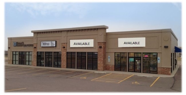


Property Detail
1511 W Holly Blvd
Sioux Falls, SD-MN
LOT A EAGLE CREEK ADDN TO CITY OF BRANDON
83361
Minnehaha
Stripcommercialcenter
South Dakota
B and X Area of moderate flood hazard, usually the area between the limits of the 100-year and 500-year floods.
a
2025
0.80 AC
2025
Sioux Falls
010403
Other Market Areas
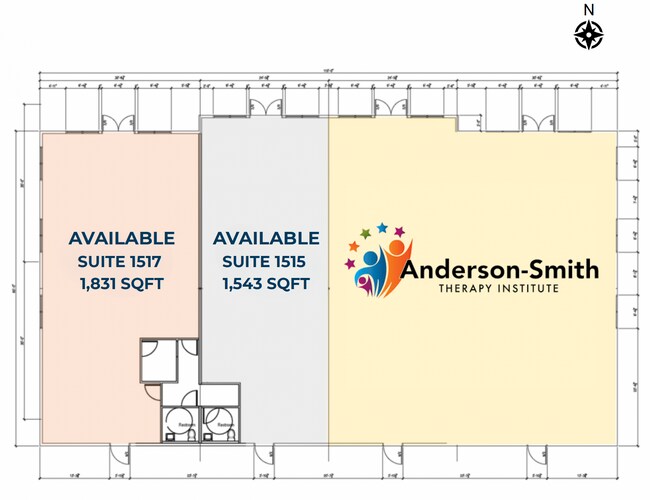
6,750 SF
NEARBY LISTINGS FOR SALE OR LEASE
-
-
View all Brandon listings for lease on LoopNet.com
DEMOGRAPHICS near 1511 W Holly Blvd
1 mile
3 mile
5 mile
2025 Total Population
981
11,788
39,437
2030 Population
1,080
12,485
41,831
Pop Growth 2025-2030
+ 10.09%
+ 5.91%
+ 6.07%
Average Age
35
37
37
2025 Total Households
318
4,179
14,414
HH Growth 2025-2030
+ 10.38%
+ 6.27%
+ 6.38%
Median Household Inc
$141,176
$109,838
$87,826
Avg Household Size
3.10
2.80
2.70
2025 Avg HH Vehicles
3.00
2.00
2.00
Median Home Value
$473,287
$360,664
$350,695
Median Year Built
2011
2000
2000
Nearby Places
Map Layers
Map Styles
 Street
 Aerial
Layers
 Traffic
 Biking
Places
Listings with unknown addresses are not visible on the map
- Restaurants
- Banks
- Shops
- Fitness
- Groceries
PUBLIC TRANSPORTATION
AIRPORT
Joe Foss Field
Drive
Walk
Distance
Joe Foss Field
30 min
10.8 mi
Freight Ports
Port Milwaukee
Drive
Walk
Distance
Port Milwaukee
540 min
495.5 mi
SALE & LEASE HISTORY
LISTING DATE
SALE/LEASE

Sep 25, 2016
For Lease
Feb 03, 2023
For Lease
Dec 27, 2022
For Lease
Nearby Properties
Address
Land Use
TOTAL SIZE
Lot Size
Zoning
Address
Land Use
TOTAL SIZE
Lot Size
Zoning
219,070 SF
43.83 AC
Address
Land Use
TOTAL SIZE
Lot Size
Zoning
81,589 SF
20 AC
Address
Land Use
TOTAL SIZE
Lot Size
Zoning
65,621 SF
10 AC
RC;CONSERV
Address
Land Use
TOTAL SIZE
Lot Size
Zoning
1,200 SF
28.70 AC
I2
Address
Land Use
TOTAL SIZE
Lot Size
Zoning
122,654 SF
15.98 AC
Address
Land Use
TOTAL SIZE
Lot Size
Zoning
37,016 SF
5.29 AC
Address
Land Use
TOTAL SIZE
Lot Size
Zoning
150,851 SF
20.57 AC
Address
Land Use
TOTAL SIZE
Lot Size
Zoning
73,562 SF
27.71 AC
Address
Land Use
TOTAL SIZE
Lot Size
Zoning
96,060 SF
11.05 AC
Address
Land Use
TOTAL SIZE
Lot Size
Zoning
133.34 AC
RR;RURAL R
Address
Land Use
TOTAL SIZE
Lot Size
Zoning
8,348 SF
3.36 AC
I3;INDUSTR
Address
Land Use
TOTAL SIZE
Lot Size
Zoning
36,148 SF
9.03 AC
Address
Land Use
TOTAL SIZE
Lot Size
Zoning
4,268 SF
45.53 AC
A1
Address
Land Use
TOTAL SIZE
Lot Size
Zoning
76,250 SF
11 AC
Address
Land Use
TOTAL SIZE
Lot Size
Zoning
126,120 SF
6.45 AC
I3;INDUSTR
Address
Land Use
TOTAL SIZE
Lot Size
Zoning
56,160 SF
4.80 AC
Address
Land Use
TOTAL SIZE
Lot Size
Zoning
52,056 SF
2 AC
Address
Land Use
TOTAL SIZE
Lot Size
Zoning
44,493 SF
2.12 AC
Address
Land Use
TOTAL SIZE
Lot Size
Zoning
54,250 SF
6.61 AC
Address
Land Use
TOTAL SIZE
Lot Size
Zoning
1,344 SF
7.66 AC
Address
Land Use
TOTAL SIZE
Lot Size
Zoning
38,112 SF
12.42 AC
Address
Land Use
TOTAL SIZE
Lot Size
Zoning
62,181 SF
6.69 AC
Address
Land Use
TOTAL SIZE
Lot Size
Zoning
22,757 SF
6.30 AC
Address
Land Use
TOTAL SIZE
Lot Size
Zoning
25,452 SF
5.58 AC
Address
Land Use
TOTAL SIZE
Lot Size
Zoning
49,071 SF
1.67 AC
B2;RETAILF
Address
Land Use
TOTAL SIZE
Lot Size
Zoning
40,200 SF
5.82 AC
Address
Land Use
TOTAL SIZE
Lot Size
Zoning
47,782 SF
4 AC
Address
Land Use
TOTAL SIZE
Lot Size
Zoning
9,100 SF
4.08 AC
Address
Land Use
TOTAL SIZE
Lot Size
Zoning
6,000 SF
9.55 AC
Address
Land Use
TOTAL SIZE
Lot Size
Zoning
43,973 SF
1.14 AC
R1;SINGLE
The World's #1 Commercial Real Estate Marketplace
Connect with us
© 2026 CoStar Group
The information above has been obtained from sources believed reliable. While we do not doubt its accuracy we have not verified it and make no guarantee, warranty or representation about it. It is your responsibility to independently confirm its accuracy and completeness. Any projections, opinions, assumptions, or estimates used are for example only and do not represent the current or future performance of the property. The value of this transaction to you depends on tax and other factors which should be evaluated by your tax, financial, and legal advisors. You and your advisors should conduct a careful, independent investigation of the property to determine to your satisfaction the suitability of the property for your needs.