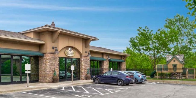
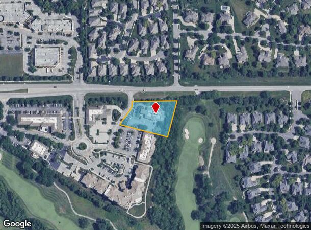
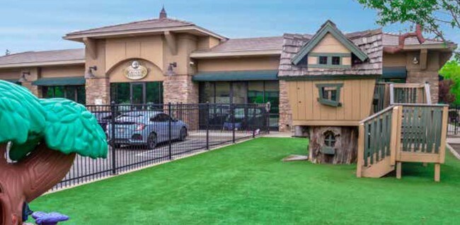
Property Record
15101 Rosewood Dr, Overland Park, KS 66224
NEARBY LISTINGS FOR SALE OR LEASE
Property Detail
15101 Rosewood Dr
Kansas City, MO-KS
Ironhorse Centre
HP22260000-0008
IRONHORSE CENTRE SECOND PLAT LT 8 LWC 652 8 8
Daycare
Johnson
X
Kansas
20091C0099G
8
2024
1.15 AC
2024
South Johnson County
053429
Kansas City
6,115 SF
DEMOGRAPHICS near 15101 Rosewood Dr
1 Mile
3 Mile
5 Mile
2024 Total Population
10,170
59,247
131,978
2029 Population
10,645
61,751
137,788
Pop Growth 2024-2029
+ 4.67%
+ 4.23%
+ 4.40%
Average Age
40
40
41
2024 Total Households
3,340
22,148
50,405
HH Growth 2024-2029
+ 4.79%
+ 4.49%
+ 4.54%
Median Household Inc
$179,424
$128,417
$123,613
Avg Household Size
3.00
2.60
2.60
2024 Avg HH Vehicles
3.00
2.00
2.00
Median Home Value
$470,017
$463,072
$456,080
Median Year Built
1998
1999
1996
Nearby Places
Map Layers
Map Styles
 Street
 Aerial
- Restaurants
- Banks
- Shops
- Fitness
- Groceries
PUBLIC TRANSPORTATION
AIRPORT
Kansas City International
DRIVE
WALK
Distance
Kansas City International
52 min
40.6 mi
SALE & LEASE HISTORY
LISTING DATE
SALE/LEASE

Jun 13, 2019
For Sale
Nearby Properties
Address
Land Use
TOTAL SIZE
Lot Size
Zoning
Address
Land Use
TOTAL SIZE
Lot Size
Zoning
1,173,824 SF
63.09 AC
R-1
Address
Land Use
TOTAL SIZE
Lot Size
Zoning
195,983 SF
20.88 AC
CP-2
Address
Land Use
TOTAL SIZE
Lot Size
Zoning
384,819 SF
67.59 AC
AG
Address
Land Use
TOTAL SIZE
Lot Size
Zoning
199,247 SF
50.19 AC
R-1
Address
Land Use
TOTAL SIZE
Lot Size
Zoning
316,630 SF
62.18 AC
RE
Address
Land Use
TOTAL SIZE
Lot Size
Zoning
239,520 SF
35.28 AC
R-1BJ
Address
Land Use
TOTAL SIZE
Lot Size
Zoning
184,524 SF
33.20 AC
AG
Address
Land Use
TOTAL SIZE
Lot Size
Zoning
173,314 SF
25.83 AC
R-1
Address
Land Use
TOTAL SIZE
Lot Size
Zoning
254,535 SF
11.97 AC
RN1
Address
Land Use
TOTAL SIZE
Lot Size
Zoning
122,491 SF
19.30 AC
R-1
Address
Land Use
TOTAL SIZE
Lot Size
Zoning
102,411 SF
17.02 AC
AG
Address
Land Use
TOTAL SIZE
Lot Size
Zoning
185,906 SF
34.09 AC
R-1
Address
Land Use
TOTAL SIZE
Lot Size
Zoning
76,942 SF
15.10 AC
R-1
Address
Land Use
TOTAL SIZE
Lot Size
Zoning
72,184 SF
9.53 AC
AG
Address
Land Use
TOTAL SIZE
Lot Size
Zoning
9,508 SF
8.29 AC
RP-1
Address
Land Use
TOTAL SIZE
Lot Size
Zoning
69,077 SF
17.90 AC
R-1
Address
Land Use
TOTAL SIZE
Lot Size
Zoning
65,388 SF
19.09 AC
RURJ
Address
Land Use
TOTAL SIZE
Lot Size
Zoning
59,770 SF
8.88 AC
CP-2
Address
Land Use
TOTAL SIZE
Lot Size
Zoning
56,287 SF
7.88 AC
R-1
Address
Land Use
TOTAL SIZE
Lot Size
Zoning
68,493 SF
9.92 AC
R-1
Address
Land Use
TOTAL SIZE
Lot Size
Zoning
40,181 SF
1.80 AC
MXD
Address
Land Use
TOTAL SIZE
Lot Size
Zoning
43,021 SF
7.47 AC
SD-O
Address
Land Use
TOTAL SIZE
Lot Size
Zoning
36,012 SF
18.10 AC
AG
Address
Land Use
TOTAL SIZE
Lot Size
Zoning
67,523 SF
11.95 AC
R-1
Address
Land Use
TOTAL SIZE
Lot Size
Zoning
170,346 SF
16.11 AC
RP-6
Address
Land Use
TOTAL SIZE
Lot Size
Zoning
69,540 SF
6.87 AC
R-1
Address
Land Use
TOTAL SIZE
Lot Size
Zoning
26,022 SF
109.48 AC
IP-2J
Address
Land Use
TOTAL SIZE
Lot Size
Zoning
31,890 SF
2.38 AC
R-1
Address
Land Use
TOTAL SIZE
Lot Size
Zoning
45,775 SF
17.05 AC
BP
Address
Land Use
TOTAL SIZE
Lot Size
Zoning
64,529 SF
11.46 AC
R-1
The World's #1 Commercial Real Estate Marketplace
Connect with us
© 2025 CoStar Group
The information above has been obtained from sources believed reliable. While we do not doubt its accuracy we have not verified it and make no guarantee, warranty or representation about it. It is your responsibility to independently confirm its accuracy and completeness. Any projections, opinions, assumptions, or estimates used are for example only and do not represent the current or future performance of the property. The value of this transaction to you depends on tax and other factors which should be evaluated by your tax, financial, and legal advisors. You and your advisors should conduct a careful, independent investigation of the property to determine to your satisfaction the suitability of the property for your needs.