Property Record
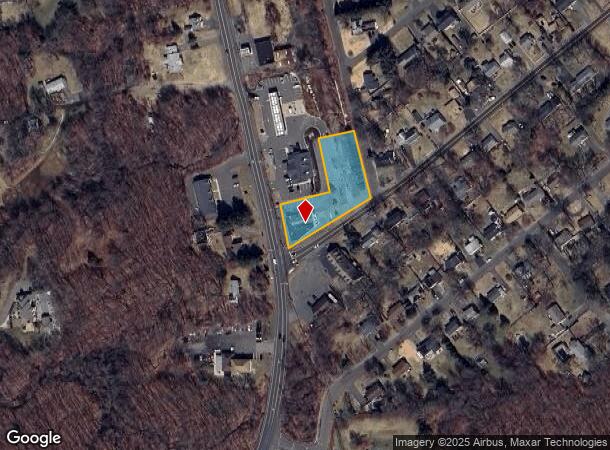
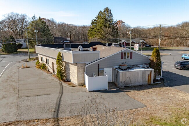
1512 Wolcott Rd, Wolcott, CT 06716

NEARBY LISTINGS FOR SALE OR LEASE
-
-
View all Wolcott listings for sale on LoopNet.com
Property Detail
1512 Wolcott Rd
WOLC-000118-000008-000268
New Haven
Commercialbuilding
Connecticut
X
268
09009C0040H
0.99 AC
2025
Waterbury
2025
Westchester/So Connecticut
361300
New Haven, CT
4,780 SF
DEMOGRAPHICS near 1512 Wolcott Rd
1 mile
3 mile
5 mile
2024 Total Population
2,418
27,749
105,719
2029 Population
2,486
28,527
108,492
Pop Growth 2024-2029
+ 2.81%
+ 2.80%
+ 2.62%
Average Age
43
41
42
2024 Total Households
878
10,831
43,323
HH Growth 2024-2029
+ 2.85%
+ 2.78%
+ 2.64%
Median Household Inc
$104,524
$101,342
$87,627
Avg Household Size
2.70
2.50
2.40
2024 Avg HH Vehicles
2.00
2.00
2.00
Median Home Value
$342,528
$300,409
$293,680
Median Year Built
1981
1969
1969
Nearby Places
Map Layers
Map Styles
 Street
 Aerial
Transit
 Traffic
 Biking
Places
Listings with unknown addresses are not visible on the map
- Restaurants
- Banks
- Shops
- Fitness
- Groceries
PUBLIC TRANSPORTATION
COMMUTER RAIL
Waterbury Station (New Haven Line - Metro-North Commuter Railroad Company (Metro-North))
Drive
Walk
Distance
Waterbury Station (New Haven Line - Metro-North Commuter Railroad Company (Metro-North))
14 min
8.2 mi
AIRPORT
Tweed/New Haven
Drive
Walk
Distance
Tweed/New Haven
51 min
30.1 mi
Bradley International
Drive
Walk
Distance
Bradley International
55 min
36.3 mi
Freight Ports
Port of New Haven
Drive
Walk
Distance
Port of New Haven
46 min
28.5 mi
Nearby Properties
Address
Land Use
TOTAL SIZE
Lot Size
Zoning
Address
Land Use
TOTAL SIZE
Lot Size
Zoning
58,473 SF
18.20 AC
IP-1
Address
Land Use
TOTAL SIZE
Lot Size
Zoning
171,826 SF
36.60 AC
R-15
Address
Land Use
TOTAL SIZE
Lot Size
Zoning
50 AC
R-40
Address
Land Use
TOTAL SIZE
Lot Size
Zoning
133,720 SF
7.34 AC
IP-1
Address
Land Use
TOTAL SIZE
Lot Size
Zoning
63,101 SF
15.50 AC
R-25
Address
Land Use
TOTAL SIZE
Lot Size
Zoning
85,155 SF
29.20 AC
R-30
Address
Land Use
TOTAL SIZE
Lot Size
Zoning
28,480 SF
5.50 AC
A
Address
Land Use
TOTAL SIZE
Lot Size
Zoning
52,542 SF
6.82 AC
R-30
Address
Land Use
TOTAL SIZE
Lot Size
Zoning
11,166 SF
32.09 AC
BG
Address
Land Use
TOTAL SIZE
Lot Size
Zoning
65,487 SF
6.40 AC
IP-1
Address
Land Use
TOTAL SIZE
Lot Size
Zoning
4,629 SF
5.20 AC
A
Address
Land Use
TOTAL SIZE
Lot Size
Zoning
58,804 SF
15 AC
BD-1/I
Address
Land Use
TOTAL SIZE
Lot Size
Zoning
16,308 SF
0.62 AC
BD-1
Address
Land Use
TOTAL SIZE
Lot Size
Zoning
9.90 AC
M
Address
Land Use
TOTAL SIZE
Lot Size
Zoning
149.84 AC
R-80
Address
Land Use
TOTAL SIZE
Lot Size
Zoning
17.44 AC
GC
Address
Land Use
TOTAL SIZE
Lot Size
Zoning
61,472 SF
3.35 AC
BD-1
Address
Land Use
TOTAL SIZE
Lot Size
Zoning
51,897 SF
4.80 AC
IP-1
Address
Land Use
TOTAL SIZE
Lot Size
Zoning
32.75 AC
R-40
Address
Land Use
TOTAL SIZE
Lot Size
Zoning
56,455 SF
5.50 AC
IP-1
Address
Land Use
TOTAL SIZE
Lot Size
Zoning
14,400 SF
31.70 AC
BG
Address
Land Use
TOTAL SIZE
Lot Size
Zoning
11.31 AC
GC
Address
Land Use
TOTAL SIZE
Lot Size
Zoning
49,959 SF
5 AC
IP-1
Address
Land Use
TOTAL SIZE
Lot Size
Zoning
6.50 AC
R-30
Address
Land Use
TOTAL SIZE
Lot Size
Zoning
1,703 SF
119.10 AC
R-40
Address
Land Use
TOTAL SIZE
Lot Size
Zoning
59,958 SF
6.79 AC
IP-1
Address
Land Use
TOTAL SIZE
Lot Size
Zoning
4,366 SF
4.90 AC
R-15
Address
Land Use
TOTAL SIZE
Lot Size
Zoning
21,774 SF
1.47 AC
R-15/B
Address
Land Use
TOTAL SIZE
Lot Size
Zoning
3,268 SF
59.65 AC
IP-3
Address
Land Use
TOTAL SIZE
Lot Size
Zoning
33,786 SF
36.56 AC
EDD-2
The World's #1 Commercial Real Estate Marketplace
Connect with us
© 2026 CoStar Group
The information above has been obtained from sources believed reliable. While we do not doubt its accuracy we have not verified it and make no guarantee, warranty or representation about it. It is your responsibility to independently confirm its accuracy and completeness. Any projections, opinions, assumptions, or estimates used are for example only and do not represent the current or future performance of the property. The value of this transaction to you depends on tax and other factors which should be evaluated by your tax, financial, and legal advisors. You and your advisors should conduct a careful, independent investigation of the property to determine to your satisfaction the suitability of the property for your needs.