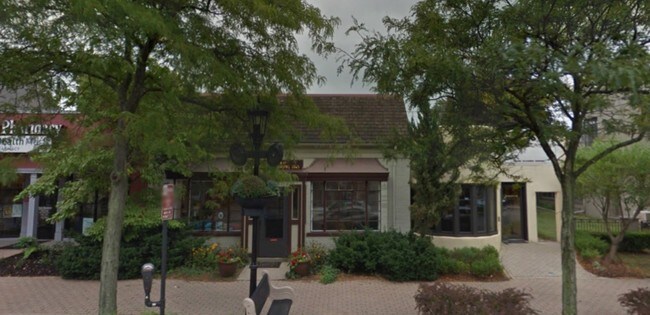
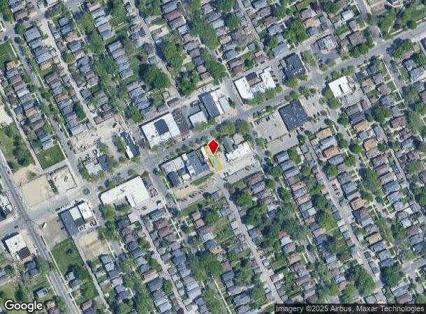
Property Record
15124 Kercheval Ave, Grosse Pointe Park, MI 48230
NEARBY LISTINGS FOR SALE OR LEASE
Property Detail
15124 Kercheval Ave
Detroit-Warren-Dearborn, MI
Berns Jefferson Ave
39-008-03-0052-000
PKSS52 LOT 52 BERNS JEFFERSON AVE SUB PC 570 L26 P22 WCR
Officebuilding
Wayne
X
Michigan
26163C0140F
52
2024
0.08 AC
2025
The Pointes/Harper Woods
550200
Detroit
1,665 SF
DEMOGRAPHICS near 15124 Kercheval Ave
1 Mile
3 Mile
5 Mile
2024 Total Population
15,923
96,033
214,638
2029 Population
15,746
95,626
214,549
Pop Growth 2024-2029
(1.11%)
(0.42%)
(0.04%)
Average Age
39
39
39
2024 Total Households
6,414
37,459
84,747
HH Growth 2024-2029
(1.08%)
(0.52%)
(0.20%)
Median Household Inc
$64,603
$46,798
$45,630
Avg Household Size
2.40
2.50
2.40
2024 Avg HH Vehicles
2.00
1.00
1.00
Median Home Value
$294,864
$168,328
$129,662
Median Year Built
1947
1948
1950
Nearby Places
Map Layers
Map Styles
 Street
 Aerial
- Restaurants
- Banks
- Shops
- Fitness
- Groceries
PUBLIC TRANSPORTATION
COMMUTER RAIL
Detroit (Wolverine - Amtrak)
DRIVE
WALK
Distance
Detroit (Wolverine - Amtrak)
17 min
8.4 mi
AIRPORT
Windsor International
DRIVE
WALK
Distance
Windsor International
39 min
15.8 mi
Detroit Metro Wayne County
DRIVE
WALK
Distance
Detroit Metro Wayne County
45 min
29.4 mi
Freight Ports
Port of Toledo
DRIVE
WALK
Distance
Port of Toledo
91 min
70.1 mi
SALE & LEASE HISTORY
LISTING DATE
SALE/LEASE

Aug 10, 2017
For Lease
Nearby Properties
Address
Land Use
TOTAL SIZE
Lot Size
Zoning
Address
Land Use
TOTAL SIZE
Lot Size
Zoning
2,958,207 SF
277.38 AC
M4
Address
Land Use
TOTAL SIZE
Lot Size
Zoning
2,005,073 SF
108.66 AC
M4
Address
Land Use
TOTAL SIZE
Lot Size
Zoning
461,840 SF
4.78 AC
R6
Address
Land Use
TOTAL SIZE
Lot Size
Zoning
929,400 SF
52.48 AC
M4
Address
Land Use
TOTAL SIZE
Lot Size
Zoning
482,649 SF
M4
Address
Land Use
TOTAL SIZE
Lot Size
Zoning
648,928 SF
5.46 AC
R6
Address
Land Use
TOTAL SIZE
Lot Size
Zoning
575,081 SF
8.53 AC
R6
Address
Land Use
TOTAL SIZE
Lot Size
Zoning
298,117 SF
15.97 AC
PD
Address
Land Use
TOTAL SIZE
Lot Size
Zoning
49,437 SF
0.47 AC
Address
Land Use
TOTAL SIZE
Lot Size
Zoning
57.16 AC
M4
Address
Land Use
TOTAL SIZE
Lot Size
Zoning
93,296 SF
1.05 AC
C-2
Address
Land Use
TOTAL SIZE
Lot Size
Zoning
62,195 SF
1.50 AC
Address
Land Use
TOTAL SIZE
Lot Size
Zoning
17,558 SF
3.15 AC
Address
Land Use
TOTAL SIZE
Lot Size
Zoning
41,000 SF
C-1
Address
Land Use
TOTAL SIZE
Lot Size
Zoning
89,897 SF
2.23 AC
Address
Land Use
TOTAL SIZE
Lot Size
Zoning
129,260 SF
3 AC
B4
Address
Land Use
TOTAL SIZE
Lot Size
Zoning
72,940 SF
83.37 AC
M4
Address
Land Use
TOTAL SIZE
Lot Size
Zoning
93,850 SF
6.56 AC
Address
Land Use
TOTAL SIZE
Lot Size
Zoning
88,695 SF
6.53 AC
PD
Address
Land Use
TOTAL SIZE
Lot Size
Zoning
115,839 SF
8.54 AC
M4
Address
Land Use
TOTAL SIZE
Lot Size
Zoning
28,055 SF
0.44 AC
Address
Land Use
TOTAL SIZE
Lot Size
Zoning
62,402 SF
0.28 AC
B4
Address
Land Use
TOTAL SIZE
Lot Size
Zoning
42,113 SF
0.54 AC
Address
Land Use
TOTAL SIZE
Lot Size
Zoning
24,826 SF
5.56 AC
B4
Address
Land Use
TOTAL SIZE
Lot Size
Zoning
77,196 SF
21.21 AC
M3
Address
Land Use
TOTAL SIZE
Lot Size
Zoning
20,625 SF
0.48 AC
C-2
Address
Land Use
TOTAL SIZE
Lot Size
Zoning
60,638 SF
0.27 AC
B4
Address
Land Use
TOTAL SIZE
Lot Size
Zoning
47,227 SF
6.29 AC
PD
Address
Land Use
TOTAL SIZE
Lot Size
Zoning
25,500 SF
0.23 AC
Address
Land Use
TOTAL SIZE
Lot Size
Zoning
60,484 SF
4.85 AC
PD
The World's #1 Commercial Real Estate Marketplace
Connect with us
© 2025 CoStar Group
The information above has been obtained from sources believed reliable. While we do not doubt its accuracy we have not verified it and make no guarantee, warranty or representation about it. It is your responsibility to independently confirm its accuracy and completeness. Any projections, opinions, assumptions, or estimates used are for example only and do not represent the current or future performance of the property. The value of this transaction to you depends on tax and other factors which should be evaluated by your tax, financial, and legal advisors. You and your advisors should conduct a careful, independent investigation of the property to determine to your satisfaction the suitability of the property for your needs.