Property Record
1521 Eureka Rd, Roseville, CA 95661
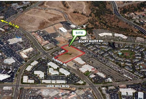
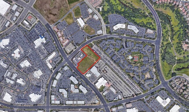

This Property Is For Sale
NEARBY LISTINGS FOR SALE OR LEASE
Property Detail
1521 Eureka Rd
048-013-014
POR PCL 2 PMOR BK 29 PG 12
Commercialacreage
Placer
X
California
06061C0963H
2.80 AC
2024
Roseville/Rocklin
2025
Sacramento
020717
Sacramento--Roseville--Arden-Arcade, CA
DEMOGRAPHICS near 1521 Eureka Rd
1 Mile
3 Mile
5 Mile
2024 Total Population
7,253
94,753
242,471
2029 Population
7,776
100,875
254,897
Pop Growth 2024-2029
+ 7.21%
+ 6.46%
+ 5.12%
Average Age
41
41
41
2024 Total Households
3,006
36,577
90,614
HH Growth 2024-2029
+ 7.42%
+ 6.57%
+ 5.20%
Median Household Inc
$116,740
$95,079
$98,005
Avg Household Size
2.30
2.50
2.60
2024 Avg HH Vehicles
2.00
2.00
2.00
Median Home Value
$720,162
$601,026
$584,121
Median Year Built
1995
1986
1987
Nearby Places
Map Layers
Map Styles
 Street
 Aerial
- Restaurants
- Banks
- Shops
- Fitness
- Groceries
PUBLIC TRANSPORTATION
COMMUTER RAIL
Roseville (California Zephyr - Amtrak, Capitol Corridor - Amtrak)
DRIVE
WALK
Distance
Roseville (California Zephyr - Amtrak, Capitol Corridor - Amtrak)
7 min
3.0 mi
Rocklin Amtrak Station (Capitol Corridor - Amtrak)
DRIVE
WALK
Distance
Rocklin Amtrak Station (Capitol Corridor - Amtrak)
7 min
3.5 mi
AIRPORT
Sacramento International
DRIVE
WALK
Distance
Sacramento International
35 min
26.5 mi
Freight Ports
Port of Stockton
DRIVE
WALK
Distance
Port of Stockton
78 min
66.7 mi
Nearby Properties
Address
Land Use
TOTAL SIZE
Lot Size
Zoning
Address
Land Use
TOTAL SIZE
Lot Size
Zoning
1,444,630 SF
53.20 AC
Address
Land Use
TOTAL SIZE
Lot Size
Zoning
678,494 SF
15.80 AC
Address
Land Use
TOTAL SIZE
Lot Size
Zoning
350,573 SF
26.30 AC
Address
Land Use
TOTAL SIZE
Lot Size
Zoning
638,040 SF
38.70 AC
Address
Land Use
TOTAL SIZE
Lot Size
Zoning
277,602 SF
26.49 AC
Address
Land Use
TOTAL SIZE
Lot Size
Zoning
210,380 SF
14.26 AC
Address
Land Use
TOTAL SIZE
Lot Size
Zoning
280,129 SF
14.90 AC
Address
Land Use
TOTAL SIZE
Lot Size
Zoning
325,462 SF
29.50 AC
Address
Land Use
TOTAL SIZE
Lot Size
Zoning
328,416 SF
17.80 AC
Address
Land Use
TOTAL SIZE
Lot Size
Zoning
105,730 SF
7.20 AC
Address
Land Use
TOTAL SIZE
Lot Size
Zoning
174,840 SF
19.70 AC
Address
Land Use
TOTAL SIZE
Lot Size
Zoning
222,702 SF
10.57 AC
Address
Land Use
TOTAL SIZE
Lot Size
Zoning
223,623 SF
12.70 AC
Address
Land Use
TOTAL SIZE
Lot Size
Zoning
132,784 SF
9.80 AC
Address
Land Use
TOTAL SIZE
Lot Size
Zoning
233,228 SF
12.10 AC
Address
Land Use
TOTAL SIZE
Lot Size
Zoning
28,798 SF
12.52 AC
Address
Land Use
TOTAL SIZE
Lot Size
Zoning
288,628 SF
11.90 AC
Address
Land Use
TOTAL SIZE
Lot Size
Zoning
143,809 SF
14.40 AC
Address
Land Use
TOTAL SIZE
Lot Size
Zoning
120,983 SF
17.60 AC
Address
Land Use
TOTAL SIZE
Lot Size
Zoning
121,000 SF
17.20 AC
Address
Land Use
TOTAL SIZE
Lot Size
Zoning
188,500 SF
20.30 AC
Address
Land Use
TOTAL SIZE
Lot Size
Zoning
142,063 SF
8.70 AC
Address
Land Use
TOTAL SIZE
Lot Size
Zoning
78,730 SF
8.03 AC
RD20 BP
Address
Land Use
TOTAL SIZE
Lot Size
Zoning
82,661 SF
7.50 AC
Address
Land Use
TOTAL SIZE
Lot Size
Zoning
118,155 SF
3.80 AC
Address
Land Use
TOTAL SIZE
Lot Size
Zoning
220,000 SF
10 AC
Address
Land Use
TOTAL SIZE
Lot Size
Zoning
119,417 SF
11 AC
Address
Land Use
TOTAL SIZE
Lot Size
Zoning
126,521 SF
11 AC
Address
Land Use
TOTAL SIZE
Lot Size
Zoning
110,744 SF
6.70 AC
Address
Land Use
TOTAL SIZE
Lot Size
Zoning
96,522 SF
19.90 AC
FBX
The World's #1 Commercial Real Estate Marketplace
Connect with us
© 2026 CoStar Group
The information above has been obtained from sources believed reliable. While we do not doubt its accuracy we have not verified it and make no guarantee, warranty or representation about it. It is your responsibility to independently confirm its accuracy and completeness. Any projections, opinions, assumptions, or estimates used are for example only and do not represent the current or future performance of the property. The value of this transaction to you depends on tax and other factors which should be evaluated by your tax, financial, and legal advisors. You and your advisors should conduct a careful, independent investigation of the property to determine to your satisfaction the suitability of the property for your needs.