Property Record
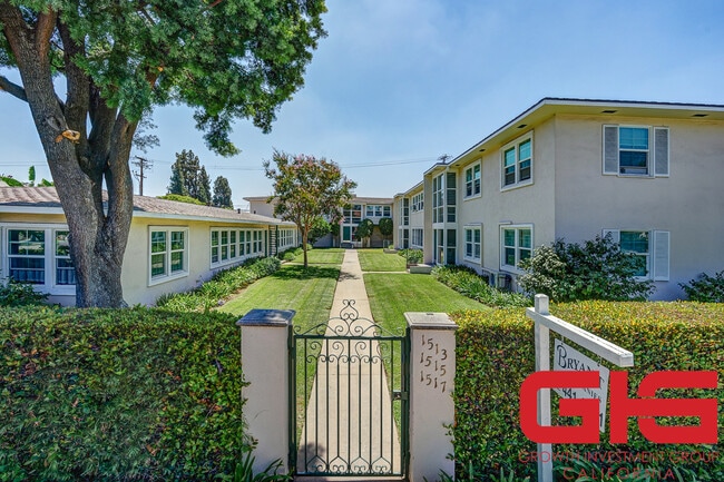
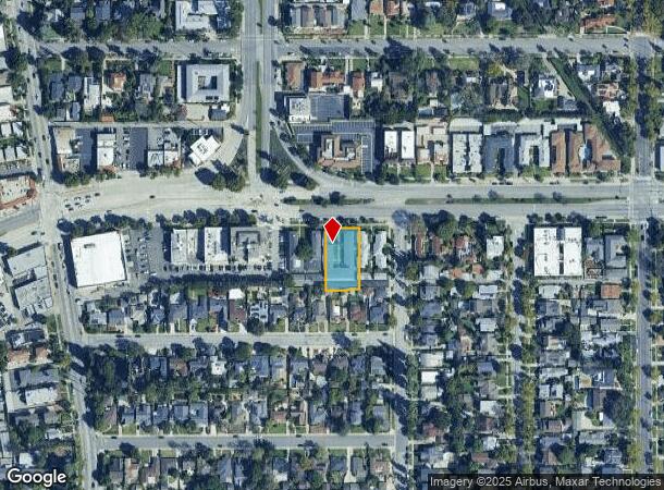
1513 Huntington Dr, South Pasadena, CA 91030
This Property Is For Sale
NEARBY LISTINGS FOR SALE OR LEASE
Property Detail
1513 Huntington Dr
Los Angeles-Long Beach-Glendale, CA
10950
5319-009-014
TRACT # 10950 LOTS 11 AND LOT 12
Multifamilydwelling
Los Angeles
X
California
06037C1635F
11,12
2024
0.42 AC
2025
South Pasadena
480704
Los Angeles
10,463 SF
DEMOGRAPHICS near 1513 Huntington Dr
1 Mile
3 Mile
5 Mile
2024 Total Population
30,318
245,824
661,734
2029 Population
30,068
243,861
654,610
Pop Growth 2024-2029
(0.82%)
(0.80%)
(1.08%)
Average Age
41
42
42
2024 Total Households
11,422
91,791
229,509
HH Growth 2024-2029
(1.07%)
(0.96%)
(1.22%)
Median Household Inc
$107,644
$101,191
$92,589
Avg Household Size
2.60
2.60
2.80
2024 Avg HH Vehicles
2.00
2.00
2.00
Median Home Value
$1,049,748
$958,983
$939,463
Median Year Built
1953
1959
1957
Nearby Places
- Restaurants
- Banks
- Shops
- Fitness
- Groceries
PUBLIC TRANSPORTATION
COMMUTER RAIL
Union Station (91 Line - Southern California Regional Rail Authority (Metrolink), Antelope Valley Line - Southern California Regional Rail Authority (Metrolink), Orange County Line - Southern California Regional Rail Authority (Metrolink), Riverside Line - Southern California Regional Rail Authority (Metrolink), San Bernardino Line - Southern California Regional Rail Authority (Metrolink), Ventura County Line - Southern California Regional Rail Authority (Metrolink))
DRIVE
WALK
Distance
Union Station (91 Line - Southern California Regional Rail Authority (Metrolink), Antelope Valley Line - Southern California Regional Rail Authority (Metrolink), Orange County Line - Southern California Regional Rail Authority (Metrolink), Riverside Line - Southern California Regional Rail Authority (Metrolink), San Bernardino Line - Southern California Regional Rail Authority (Metrolink), Ventura County Line - Southern California Regional Rail Authority (Metrolink))
14 min
6.9 mi
AIRPORT
Bob Hope
DRIVE
WALK
Distance
Bob Hope
28 min
19.0 mi
Long Beach (Daugherty Field)
DRIVE
WALK
Distance
Long Beach (Daugherty Field)
34 min
23.1 mi
Los Angeles International
DRIVE
WALK
Distance
Los Angeles International
37 min
23.9 mi
Freight Ports
Port of Long Beach
DRIVE
WALK
Distance
Port of Long Beach
36 min
25.9 mi
Nearby Properties
Address
Land Use
TOTAL SIZE
Lot Size
Zoning
Address
Land Use
TOTAL SIZE
Lot Size
Zoning
874,871 SF
25.01 AC
PSC*
Address
Land Use
TOTAL SIZE
Lot Size
Zoning
327,804 SF
17.76 AC
PSR*
Address
Land Use
TOTAL SIZE
Lot Size
Zoning
460,590 SF
23.95 AC
ALMPD*
Address
Land Use
TOTAL SIZE
Lot Size
Zoning
523,298 SF
5.74 AC
PSC-
Address
Land Use
TOTAL SIZE
Lot Size
Zoning
11,590 SF
14.43 AC
PSC*
Address
Land Use
TOTAL SIZE
Lot Size
Zoning
262,988 SF
1.42 AC
PSR*
Address
Land Use
TOTAL SIZE
Lot Size
Zoning
91,229 SF
206.59 AC
SOH
Address
Land Use
TOTAL SIZE
Lot Size
Zoning
385,765 SF
4.41 AC
PSC-
Address
Land Use
TOTAL SIZE
Lot Size
Zoning
516,474 SF
4.37 AC
ALCBD/DRD*
Address
Land Use
TOTAL SIZE
Lot Size
Zoning
192,792 SF
14.52 AC
PSR
Address
Land Use
TOTAL SIZE
Lot Size
Zoning
588,972 SF
2.59 AC
PSC-
Address
Land Use
TOTAL SIZE
Lot Size
Zoning
372,451 SF
3.24 AC
PSC*
Address
Land Use
TOTAL SIZE
Lot Size
Zoning
255,343 SF
0.80 AC
PSC-
Address
Land Use
TOTAL SIZE
Lot Size
Zoning
266,947 SF
10.91 AC
PSC2
Address
Land Use
TOTAL SIZE
Lot Size
Zoning
91,145 SF
1.21 AC
PSC-
Address
Land Use
TOTAL SIZE
Lot Size
Zoning
100,653 SF
1.41 AC
PSC-
Address
Land Use
TOTAL SIZE
Lot Size
Zoning
151,450 SF
6.59 AC
MPSP*
Address
Land Use
TOTAL SIZE
Lot Size
Zoning
203,067 SF
0.62 AC
PSC-
Address
Land Use
TOTAL SIZE
Lot Size
Zoning
220,717 SF
2.14 AC
MPSP*
Address
Land Use
TOTAL SIZE
Lot Size
Zoning
452,713 SF
28.21 AC
PSC*
Address
Land Use
TOTAL SIZE
Lot Size
Zoning
217,778 SF
1.81 AC
PSC-
Address
Land Use
TOTAL SIZE
Lot Size
Zoning
161,825 SF
4.04 AC
PSC*
Address
Land Use
TOTAL SIZE
Lot Size
Zoning
225,995 SF
10.86 AC
PSC2*
Address
Land Use
TOTAL SIZE
Lot Size
Zoning
345,558 SF
2.88 AC
PSC-
Address
Land Use
TOTAL SIZE
Lot Size
Zoning
158,307 SF
2.23 AC
PSC-
Address
Land Use
TOTAL SIZE
Lot Size
Zoning
148,214 SF
1.33 AC
PSC-
Address
Land Use
TOTAL SIZE
Lot Size
Zoning
10.85 AC
PSC-
Address
Land Use
TOTAL SIZE
Lot Size
Zoning
130,553 SF
1.93 AC
PSR*
Address
Land Use
TOTAL SIZE
Lot Size
Zoning
52,970 SF
0.84 AC
PSC-
The World's #1 Commercial Real Estate Marketplace
Connect with us
© 2025 CoStar Group
The information above has been obtained from sources believed reliable. While we do not doubt its accuracy we have not verified it and make no guarantee, warranty or representation about it. It is your responsibility to independently confirm its accuracy and completeness. Any projections, opinions, assumptions, or estimates used are for example only and do not represent the current or future performance of the property. The value of this transaction to you depends on tax and other factors which should be evaluated by your tax, financial, and legal advisors. You and your advisors should conduct a careful, independent investigation of the property to determine to your satisfaction the suitability of the property for your needs.