Property Record
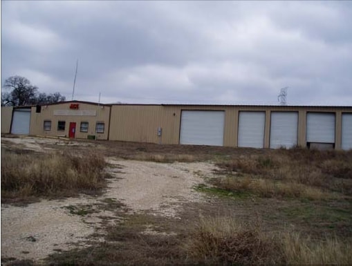
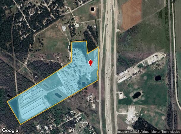
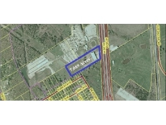
15131 N Interstate Highway 35, Elm Mott, TX 76640
NEARBY LISTINGS FOR SALE OR LEASE
-
-
View all Elm Mott listings for sale on LoopNet.com
Property Detail
15131 N Interstate Highway 35
50-003400-002208-0
Rutherford Jos
Commercialnec
RUTHERFORD JOS ACRES 34.1143
X
Mclennan
48309C0225D
Texas
2024
34.11 AC
2025
Other Market Areas
003402
Waco, TX
9,694 SF
DEMOGRAPHICS near 15131 N Interstate Highway 35
1 Mile
3 Mile
5 Mile
2024 Total Population
552
3,171
11,359
2029 Population
562
3,240
11,916
Pop Growth 2024-2029
+ 1.81%
+ 2.18%
+ 4.90%
Average Age
40
41
38
2024 Total Households
203
1,190
4,136
HH Growth 2024-2029
+ 1.97%
+ 2.27%
+ 5.13%
Median Household Inc
$62,763
$71,573
$59,481
Avg Household Size
2.60
2.60
2.60
2024 Avg HH Vehicles
2.00
2.00
2.00
Median Home Value
$154,687
$177,777
$169,217
Median Year Built
1982
1983
1980
Nearby Places
Map Layers
Map Styles
 Street
 Aerial
- Restaurants
- Banks
- Shops
- Fitness
- Groceries
PUBLIC TRANSPORTATION
AIRPORT
Waco Regional
DRIVE
WALK
Distance
Waco Regional
29 min
16.3 mi
Freight Ports
Port of Houston
DRIVE
WALK
Distance
Port of Houston
224 min
194.1 mi
Nearby Properties
Address
Land Use
TOTAL SIZE
Lot Size
Zoning
Address
Land Use
TOTAL SIZE
Lot Size
Zoning
182,614 SF
25.49 AC
C
Address
Land Use
TOTAL SIZE
Lot Size
Zoning
79,000 SF
6.09 AC
R
Address
Land Use
TOTAL SIZE
Lot Size
Zoning
40,270 SF
51.91 AC
R
Address
Land Use
TOTAL SIZE
Lot Size
Zoning
13,379 SF
8.99 AC
C
Address
Land Use
TOTAL SIZE
Lot Size
Zoning
70,675 SF
19.48 AC
C
Address
Land Use
TOTAL SIZE
Lot Size
Zoning
45,000 SF
8.01 AC
R
Address
Land Use
TOTAL SIZE
Lot Size
Zoning
82,965 SF
10.77 AC
R
Address
Land Use
TOTAL SIZE
Lot Size
Zoning
20,639 SF
11.53 AC
C
Address
Land Use
TOTAL SIZE
Lot Size
Zoning
1,800 SF
24.77 AC
C
Address
Land Use
TOTAL SIZE
Lot Size
Zoning
23,274 SF
5 AC
R
Address
Land Use
TOTAL SIZE
Lot Size
Zoning
4,624 SF
0.78 AC
C
Address
Land Use
TOTAL SIZE
Lot Size
Zoning
18,850 SF
21.94 AC
R
Address
Land Use
TOTAL SIZE
Lot Size
Zoning
48,790 SF
4.01 AC
C
Address
Land Use
TOTAL SIZE
Lot Size
Zoning
33,720 SF
10 AC
R
Address
Land Use
TOTAL SIZE
Lot Size
Zoning
15,140 SF
21.74 AC
Address
Land Use
TOTAL SIZE
Lot Size
Zoning
12,952 SF
4.08 AC
R
Address
Land Use
TOTAL SIZE
Lot Size
Zoning
26,102 SF
5.66 AC
Address
Land Use
TOTAL SIZE
Lot Size
Zoning
16,360 SF
58.66 AC
C
Address
Land Use
TOTAL SIZE
Lot Size
Zoning
17,500 SF
5.18 AC
C
Address
Land Use
TOTAL SIZE
Lot Size
Zoning
36,001 SF
8.82 AC
R
Address
Land Use
TOTAL SIZE
Lot Size
Zoning
9,065 SF
1.62 AC
R
Address
Land Use
TOTAL SIZE
Lot Size
Zoning
7,123 SF
14.62 AC
C
Address
Land Use
TOTAL SIZE
Lot Size
Zoning
20,550 SF
5.58 AC
R
Address
Land Use
TOTAL SIZE
Lot Size
Zoning
20,290 SF
6.77 AC
R
Address
Land Use
TOTAL SIZE
Lot Size
Zoning
21,871 SF
7.92 AC
R
Address
Land Use
TOTAL SIZE
Lot Size
Zoning
2,040 SF
12.74 AC
R
Address
Land Use
TOTAL SIZE
Lot Size
Zoning
4,890 SF
8 AC
Address
Land Use
TOTAL SIZE
Lot Size
Zoning
8,300 SF
18.55 AC
R
Address
Land Use
TOTAL SIZE
Lot Size
Zoning
8,135 SF
8.33 AC
C
The World's #1 Commercial Real Estate Marketplace
Connect with us
© 2025 CoStar Group
The information above has been obtained from sources believed reliable. While we do not doubt its accuracy we have not verified it and make no guarantee, warranty or representation about it. It is your responsibility to independently confirm its accuracy and completeness. Any projections, opinions, assumptions, or estimates used are for example only and do not represent the current or future performance of the property. The value of this transaction to you depends on tax and other factors which should be evaluated by your tax, financial, and legal advisors. You and your advisors should conduct a careful, independent investigation of the property to determine to your satisfaction the suitability of the property for your needs.