Property Record
1514 Fernwood Glendale Rd, Spartanburg, SC 29307
NEARBY LISTINGS FOR SALE OR LEASE
-
-
View all Spartanburg listings for sale on LoopNet.com
Property Detail
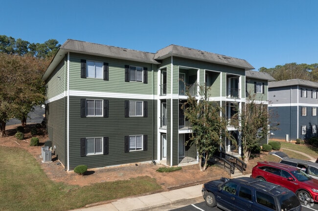
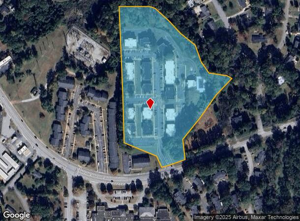
1514 Fernwood Glendale Rd
7-13-04-021.00
Survey/Tgm Seville Inc
Commercialnec
N OF FERNWOOD GLENDALE RD E OF ROMAINE DR PB 84-807 PB 68-510
AE
Spartanburg
45083C0259D
South Carolina
0
10.55 AC
2025
Hillbrook
021303
Greenville/Spartanburg
5,414 SF
Spartanburg, SC
DEMOGRAPHICS near 1514 Fernwood Glendale Rd
1 Mile
3 Mile
5 Mile
2024 Total Population
4,569
31,473
70,059
2029 Population
5,112
35,402
79,542
Pop Growth 2024-2029
+ 11.88%
+ 12.48%
+ 13.54%
Average Age
43
41
40
2024 Total Households
2,059
13,481
28,656
HH Growth 2024-2029
+ 12.09%
+ 12.97%
+ 14.01%
Median Household Inc
$75,219
$57,172
$47,157
Avg Household Size
2.20
2.20
2.30
2024 Avg HH Vehicles
2.00
2.00
2.00
Median Home Value
$239,980
$210,943
$167,311
Median Year Built
1976
1972
1973
Nearby Places
Map Layers
Map Styles
 Street
 Aerial
- Restaurants
- Banks
- Shops
- Fitness
- Groceries
PUBLIC TRANSPORTATION
COMMUTER RAIL
Spartanburg Amtrak Station (Crescent - Amtrak)
DRIVE
WALK
Distance
Spartanburg Amtrak Station (Crescent - Amtrak)
10 min
4.2 mi
AIRPORT
Greenville Spartanburg International
DRIVE
WALK
Distance
Greenville Spartanburg International
38 min
25.0 mi
Freight Ports
North Charleston Terminal
DRIVE
WALK
Distance
North Charleston Terminal
230 min
197.9 mi
Nearby Properties
Address
Land Use
TOTAL SIZE
Lot Size
Zoning
Address
Land Use
TOTAL SIZE
Lot Size
Zoning
9,312 SF
9.06 AC
Address
Land Use
TOTAL SIZE
Lot Size
Zoning
15,108 SF
16.27 AC
Address
Land Use
TOTAL SIZE
Lot Size
Zoning
18,600 SF
3.41 AC
Address
Land Use
TOTAL SIZE
Lot Size
Zoning
106,100 SF
24.56 AC
Address
Land Use
TOTAL SIZE
Lot Size
Zoning
31,913 SF
1.03 AC
Address
Land Use
TOTAL SIZE
Lot Size
Zoning
9,146 SF
51.62 AC
Address
Land Use
TOTAL SIZE
Lot Size
Zoning
2,864 SF
3.72 AC
Address
Land Use
TOTAL SIZE
Lot Size
Zoning
19,796 SF
3.56 AC
Address
Land Use
TOTAL SIZE
Lot Size
Zoning
14.80 AC
Address
Land Use
TOTAL SIZE
Lot Size
Zoning
16.45 AC
Address
Land Use
TOTAL SIZE
Lot Size
Zoning
88.30 AC
Address
Land Use
TOTAL SIZE
Lot Size
Zoning
3,648 SF
20.77 AC
Address
Land Use
TOTAL SIZE
Lot Size
Zoning
18,443 SF
0.58 AC
Address
Land Use
TOTAL SIZE
Lot Size
Zoning
106,389 SF
3.15 AC
Address
Land Use
TOTAL SIZE
Lot Size
Zoning
214,026 SF
29.83 AC
Address
Land Use
TOTAL SIZE
Lot Size
Zoning
27,608 SF
17.61 AC
Address
Land Use
TOTAL SIZE
Lot Size
Zoning
6,879 SF
135.30 AC
Address
Land Use
TOTAL SIZE
Lot Size
Zoning
3,363 SF
8.10 AC
Address
Land Use
TOTAL SIZE
Lot Size
Zoning
173,817 SF
0.85 AC
Address
Land Use
TOTAL SIZE
Lot Size
Zoning
Address
Land Use
TOTAL SIZE
Lot Size
Zoning
7,570 SF
24.50 AC
Address
Land Use
TOTAL SIZE
Lot Size
Zoning
156,683 SF
11.23 AC
Address
Land Use
TOTAL SIZE
Lot Size
Zoning
26,086 SF
12.95 AC
Address
Land Use
TOTAL SIZE
Lot Size
Zoning
3,254 SF
0.83 AC
Address
Land Use
TOTAL SIZE
Lot Size
Zoning
27,579 SF
3.08 AC
Address
Land Use
TOTAL SIZE
Lot Size
Zoning
67,704 SF
0.50 AC
Address
Land Use
TOTAL SIZE
Lot Size
Zoning
119,443 SF
13.64 AC
Address
Land Use
TOTAL SIZE
Lot Size
Zoning
3,848 SF
0.53 AC
Address
Land Use
TOTAL SIZE
Lot Size
Zoning
5,568 SF
0.56 AC
Address
Land Use
TOTAL SIZE
Lot Size
Zoning
522 SF
8.33 AC
The World's #1 Commercial Real Estate Marketplace
Connect with us
© 2025 CoStar Group
The information above has been obtained from sources believed reliable. While we do not doubt its accuracy we have not verified it and make no guarantee, warranty or representation about it. It is your responsibility to independently confirm its accuracy and completeness. Any projections, opinions, assumptions, or estimates used are for example only and do not represent the current or future performance of the property. The value of this transaction to you depends on tax and other factors which should be evaluated by your tax, financial, and legal advisors. You and your advisors should conduct a careful, independent investigation of the property to determine to your satisfaction the suitability of the property for your needs.