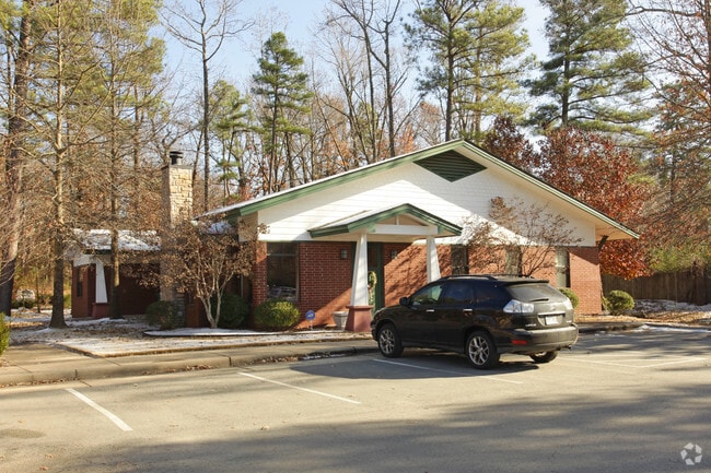
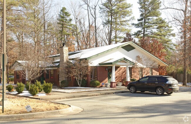
Property Record
1515 Aldersgate Rd, Little Rock, AR 72205
NEARBY LISTINGS FOR SALE OR LEASE
Property Detail
1515 Aldersgate Rd
Little Rock-North Little Rock-Conway, AR
Baptist Health Kanis South Add
44L-080-01-012-02
BEING A REPLAT OF LOT 12 NOW REPLATTED AS LOT 12C
Medicalbuilding
Pulaski
X
Arkansas
05125C0250E
12c
2025
0.75 AC
2025
Midtown
002410
Little Rock/N Little Rock
3,089 SF
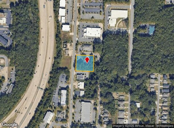
DEMOGRAPHICS near 1515 Aldersgate Rd
1 Mile
3 Mile
5 Mile
2024 Total Population
5,443
66,913
139,762
2029 Population
5,431
66,633
139,825
Pop Growth 2024-2029
(0.22%)
(0.42%)
+ 0.05%
Average Age
40
39
39
2024 Total Households
2,534
30,295
61,597
HH Growth 2024-2029
(0.24%)
(0.49%)
+ 0.05%
Median Household Inc
$36,557
$54,361
$56,176
Avg Household Size
2.10
2.10
2.20
2024 Avg HH Vehicles
1.00
2.00
2.00
Median Home Value
$139,528
$181,379
$199,472
Median Year Built
1976
1978
1977
Nearby Places
Map Layers
Map Styles
 Street
 Aerial
- Restaurants
- Banks
- Shops
- Fitness
- Groceries
PUBLIC TRANSPORTATION
COMMUTER RAIL
Little Rock Union Station (Texas Eagle - Amtrak)
DRIVE
WALK
Distance
Little Rock Union Station (Texas Eagle - Amtrak)
13 min
7.5 mi
AIRPORT
Bill and Hillary Clinton Ntl/Adams Field
DRIVE
WALK
Distance
Bill and Hillary Clinton Ntl/Adams Field
19 min
12.2 mi
Freight Ports
Port of Shreveport
DRIVE
WALK
Distance
Port of Shreveport
245 min
228.6 mi
SALE & LEASE HISTORY
LISTING DATE
SALE/LEASE

Apr 16, 2019
For Sale
Nearby Properties
Address
Land Use
TOTAL SIZE
Lot Size
Zoning
Address
Land Use
TOTAL SIZE
Lot Size
Zoning
1,665,090 SF
34.75 AC
Address
Land Use
TOTAL SIZE
Lot Size
Zoning
1,909,430 SF
29.12 AC
Address
Land Use
TOTAL SIZE
Lot Size
Zoning
227,729 SF
36.49 AC
Address
Land Use
TOTAL SIZE
Lot Size
Zoning
115,378 SF
30.50 AC
Address
Land Use
TOTAL SIZE
Lot Size
Zoning
143,885 SF
14.98 AC
Address
Land Use
TOTAL SIZE
Lot Size
Zoning
145,580 SF
19.89 AC
Address
Land Use
TOTAL SIZE
Lot Size
Zoning
39,635 SF
15.76 AC
Address
Land Use
TOTAL SIZE
Lot Size
Zoning
35,086 SF
6.48 AC
Address
Land Use
TOTAL SIZE
Lot Size
Zoning
220,563 SF
12.36 AC
Address
Land Use
TOTAL SIZE
Lot Size
Zoning
140,675 SF
Address
Land Use
TOTAL SIZE
Lot Size
Zoning
48,982 SF
9.06 AC
Address
Land Use
TOTAL SIZE
Lot Size
Zoning
130,800 SF
7.78 AC
Address
Land Use
TOTAL SIZE
Lot Size
Zoning
221,911 SF
10.31 AC
Address
Land Use
TOTAL SIZE
Lot Size
Zoning
127,020 SF
13.56 AC
Address
Land Use
TOTAL SIZE
Lot Size
Zoning
57,494 SF
9.53 AC
Address
Land Use
TOTAL SIZE
Lot Size
Zoning
19,142 SF
5.54 AC
Address
Land Use
TOTAL SIZE
Lot Size
Zoning
221,204 SF
4.54 AC
Address
Land Use
TOTAL SIZE
Lot Size
Zoning
210,924 SF
22.66 AC
Address
Land Use
TOTAL SIZE
Lot Size
Zoning
54,284 SF
11.33 AC
Address
Land Use
TOTAL SIZE
Lot Size
Zoning
404,617 SF
9.51 AC
Address
Land Use
TOTAL SIZE
Lot Size
Zoning
185,873 SF
Address
Land Use
TOTAL SIZE
Lot Size
Zoning
48,470 SF
26.37 AC
Address
Land Use
TOTAL SIZE
Lot Size
Zoning
74,220 SF
15.49 AC
Address
Land Use
TOTAL SIZE
Lot Size
Zoning
14,902 SF
5.04 AC
Address
Land Use
TOTAL SIZE
Lot Size
Zoning
238,164 SF
34.25 AC
Address
Land Use
TOTAL SIZE
Lot Size
Zoning
122,775 SF
9.96 AC
Address
Land Use
TOTAL SIZE
Lot Size
Zoning
155,943 SF
10.59 AC
Address
Land Use
TOTAL SIZE
Lot Size
Zoning
21,640 SF
20 AC
Address
Land Use
TOTAL SIZE
Lot Size
Zoning
33,992 SF
13.15 AC
Address
Land Use
TOTAL SIZE
Lot Size
Zoning
129,239 SF
9.01 AC
The World's #1 Commercial Real Estate Marketplace
Connect with us
© 2025 CoStar Group
The information above has been obtained from sources believed reliable. While we do not doubt its accuracy we have not verified it and make no guarantee, warranty or representation about it. It is your responsibility to independently confirm its accuracy and completeness. Any projections, opinions, assumptions, or estimates used are for example only and do not represent the current or future performance of the property. The value of this transaction to you depends on tax and other factors which should be evaluated by your tax, financial, and legal advisors. You and your advisors should conduct a careful, independent investigation of the property to determine to your satisfaction the suitability of the property for your needs.