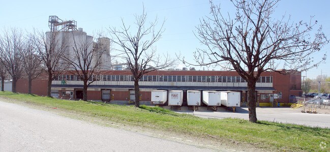
Property Record
1515 Drover St, Indianapolis, IN 46221


NEARBY LISTINGS FOR SALE OR LEASE
Property Detail
1515 Drover St
Indianapolis-Carmel-Greenwood, IN
S Of C St E Of Drover St N Of Belt Rr &
49-11-14-143-007.000-101
S OF C ST E OF DROVER ST N OF BELT RR & W OFRIVER S PT NW1/4 SW1/4 S14 T15 R3 30.396 AC+-
Industrialgeneral
Marion
2023
Indiana
2024
30.40 AC
358100
White River Pkwy
290,472 SF
Indianapolis
DEMOGRAPHICS near 1515 Drover St
1 Mile
3 Mile
5 Mile
2024 Total Population
4,273
90,760
247,932
2029 Population
4,338
92,331
250,220
Pop Growth 2024-2029
+ 1.52%
+ 1.73%
+ 0.92%
Average Age
36
35
35
2024 Total Households
1,605
40,545
102,564
HH Growth 2024-2029
+ 1.68%
+ 1.80%
+ 0.99%
Median Household Inc
$34,298
$57,044
$50,770
Avg Household Size
2.60
2.10
2.30
2024 Avg HH Vehicles
1.00
1.00
2.00
Median Home Value
$84,229
$179,703
$141,751
Median Year Built
1947
1956
1955
Nearby Places
Map Layers
Map Styles
 Street
 Aerial
- Restaurants
- Banks
- Shops
- Fitness
- Groceries
PUBLIC TRANSPORTATION
COMMUTER RAIL
Indianapolis (Cardinal - Amtrak)
DRIVE
WALK
Distance
Indianapolis (Cardinal - Amtrak)
4 min
1.8 mi
AIRPORT
Indianapolis International
DRIVE
WALK
Distance
Indianapolis International
24 min
12.0 mi
Freight Ports
Port of Toledo
DRIVE
WALK
Distance
Port of Toledo
274 min
228.2 mi
Nearby Properties
Address
Land Use
TOTAL SIZE
Lot Size
Zoning
Address
Land Use
TOTAL SIZE
Lot Size
Zoning
33.61 AC
ZO01
Address
Land Use
TOTAL SIZE
Lot Size
Zoning
1,381,492 SF
15.08 AC
ZO01
Address
Land Use
TOTAL SIZE
Lot Size
Zoning
546,391 SF
4.38 AC
ZO01
Address
Land Use
TOTAL SIZE
Lot Size
Zoning
5.59 AC
ZO01
Address
Land Use
TOTAL SIZE
Lot Size
Zoning
23,200 SF
1.71 AC
Address
Land Use
TOTAL SIZE
Lot Size
Zoning
302,187 SF
1.97 AC
ZO01
Address
Land Use
TOTAL SIZE
Lot Size
Zoning
19,536 SF
4.05 AC
ZO01
Address
Land Use
TOTAL SIZE
Lot Size
Zoning
83,966 SF
2.30 AC
ZO01
Address
Land Use
TOTAL SIZE
Lot Size
Zoning
2,273 SF
1.52 AC
ZO01
Address
Land Use
TOTAL SIZE
Lot Size
Zoning
12,392 SF
0.99 AC
ZO01
Address
Land Use
TOTAL SIZE
Lot Size
Zoning
44,485 SF
0.76 AC
ZO01
Address
Land Use
TOTAL SIZE
Lot Size
Zoning
500,908 SF
10.36 AC
ZO01
Address
Land Use
TOTAL SIZE
Lot Size
Zoning
19,896 SF
32.59 AC
ZO01
Address
Land Use
TOTAL SIZE
Lot Size
Zoning
170,000 SF
4.05 AC
ZO01
Address
Land Use
TOTAL SIZE
Lot Size
Zoning
20,422 SF
0.42 AC
ZO01
Address
Land Use
TOTAL SIZE
Lot Size
Zoning
12.63 AC
ZO01
Address
Land Use
TOTAL SIZE
Lot Size
Zoning
384,520 SF
1.93 AC
ZO01
Address
Land Use
TOTAL SIZE
Lot Size
Zoning
123,373 SF
2.14 AC
ZO01
Address
Land Use
TOTAL SIZE
Lot Size
Zoning
5,200 SF
2.43 AC
ZO01
Address
Land Use
TOTAL SIZE
Lot Size
Zoning
6,000 SF
0.47 AC
ZO01
Address
Land Use
TOTAL SIZE
Lot Size
Zoning
21,809 SF
1.57 AC
ZO01
Address
Land Use
TOTAL SIZE
Lot Size
Zoning
36,000 SF
0.94 AC
ZO01
Address
Land Use
TOTAL SIZE
Lot Size
Zoning
40,205 SF
1.58 AC
Address
Land Use
TOTAL SIZE
Lot Size
Zoning
11,775 SF
0.44 AC
ZO01
Address
Land Use
TOTAL SIZE
Lot Size
Zoning
309,006 SF
1.48 AC
ZO01
Address
Land Use
TOTAL SIZE
Lot Size
Zoning
2,674 SF
3.05 AC
ZO01
Address
Land Use
TOTAL SIZE
Lot Size
Zoning
217,895 SF
3.43 AC
ZO01
Address
Land Use
TOTAL SIZE
Lot Size
Zoning
245,608 SF
0.90 AC
Address
Land Use
TOTAL SIZE
Lot Size
Zoning
11,230 SF
0.53 AC
ZO02
Address
Land Use
TOTAL SIZE
Lot Size
Zoning
45,971 SF
0.78 AC
The World's #1 Commercial Real Estate Marketplace
Connect with us
© 2026 CoStar Group
The information above has been obtained from sources believed reliable. While we do not doubt its accuracy we have not verified it and make no guarantee, warranty or representation about it. It is your responsibility to independently confirm its accuracy and completeness. Any projections, opinions, assumptions, or estimates used are for example only and do not represent the current or future performance of the property. The value of this transaction to you depends on tax and other factors which should be evaluated by your tax, financial, and legal advisors. You and your advisors should conduct a careful, independent investigation of the property to determine to your satisfaction the suitability of the property for your needs.