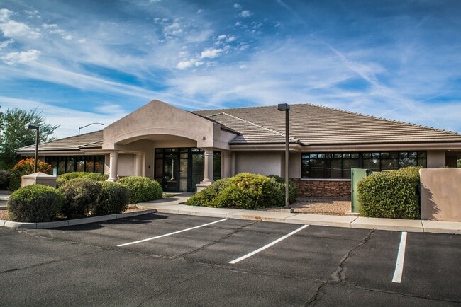
Property Record
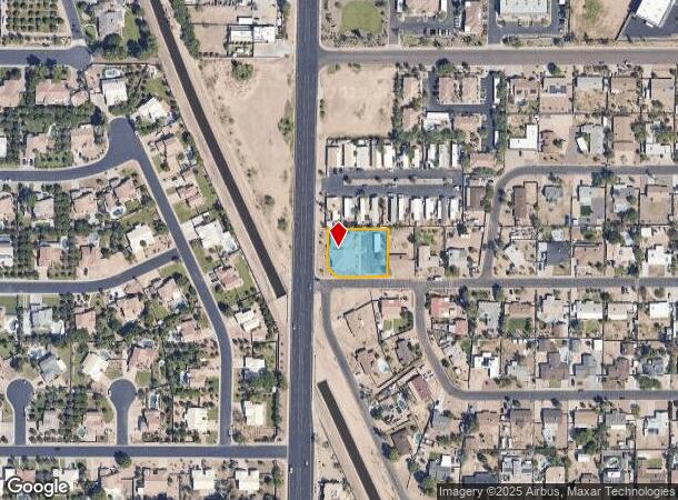
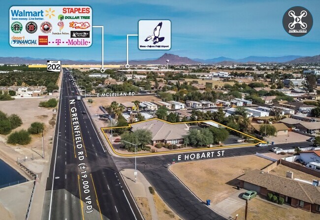
1515 N Greenfield Rd, Mesa, AZ 85205

NEARBY LISTINGS FOR SALE OR LEASE
Property Detail
1515 N Greenfield Rd
Phoenix-Mesa-Scottsdale, AZ
Falcon Estates Lots 1-24, 73-104, 153-16
141-72-071W
FALCON ESTATES LOTS 1-24, 73-104, 153-166 TR A MCR 80/21
Officebuilding
Maricopa
AH
Arizona
04013C2280L
a
2025
0.56 AC
2025
Mesa East
420215
Phoenix
5,618 SF
DEMOGRAPHICS near 1515 N Greenfield Rd
1 Mile
3 Mile
5 Mile
2024 Total Population
7,471
106,926
259,858
2029 Population
8,008
116,588
282,182
Pop Growth 2024-2029
+ 7.19%
+ 9.04%
+ 8.59%
Average Age
38
47
43
2024 Total Households
2,451
45,560
102,796
HH Growth 2024-2029
+ 7.18%
+ 9.67%
+ 9.07%
Median Household Inc
$110,987
$65,751
$69,661
Avg Household Size
3.00
2.30
2.40
2024 Avg HH Vehicles
2.00
2.00
2.00
Median Home Value
$401,174
$310,356
$335,959
Median Year Built
1987
1986
1986
Nearby Places
Map Layers
Map Styles
 Street
 Aerial
- Restaurants
- Banks
- Shops
- Fitness
- Groceries
PUBLIC TRANSPORTATION
AIRPORT
Phoenix-Mesa Gateway
DRIVE
WALK
Distance
Phoenix-Mesa Gateway
25 min
13.7 mi
Phoenix Sky Harbor International
DRIVE
WALK
Distance
Phoenix Sky Harbor International
27 min
16.9 mi
SALE & LEASE HISTORY
LISTING DATE
SALE/LEASE

Nov 17, 2020
For Sale
Dec 26, 2018
For Lease
Dec 26, 2018
For Sale
Aug 04, 2020
For Sale
Nearby Properties
Address
Land Use
TOTAL SIZE
Lot Size
Zoning
Address
Land Use
TOTAL SIZE
Lot Size
Zoning
181.80 AC
Address
Land Use
TOTAL SIZE
Lot Size
Zoning
125,356 SF
21.63 AC
R-9
Address
Land Use
TOTAL SIZE
Lot Size
Zoning
53,910 SF
4.98 AC
C-G
Address
Land Use
TOTAL SIZE
Lot Size
Zoning
1,691,248 SF
528.80 AC
I-1
Address
Land Use
TOTAL SIZE
Lot Size
Zoning
29.74 AC
Address
Land Use
TOTAL SIZE
Lot Size
Zoning
22.19 AC
Address
Land Use
TOTAL SIZE
Lot Size
Zoning
1,217,466 SF
102.41 AC
I-1
Address
Land Use
TOTAL SIZE
Lot Size
Zoning
400,798 SF
55.94 AC
PF
Address
Land Use
TOTAL SIZE
Lot Size
Zoning
22.71 AC
Address
Land Use
TOTAL SIZE
Lot Size
Zoning
20.08 AC
Address
Land Use
TOTAL SIZE
Lot Size
Zoning
161,388 SF
32.52 AC
R-35
Address
Land Use
TOTAL SIZE
Lot Size
Zoning
279,338 SF
39.90 AC
PF
Address
Land Use
TOTAL SIZE
Lot Size
Zoning
66,350 SF
22.32 AC
I-1
Address
Land Use
TOTAL SIZE
Lot Size
Zoning
158,514 SF
21.39 AC
Address
Land Use
TOTAL SIZE
Lot Size
Zoning
8.82 AC
Address
Land Use
TOTAL SIZE
Lot Size
Zoning
147,408 SF
34.58 AC
PF
Address
Land Use
TOTAL SIZE
Lot Size
Zoning
349,318 SF
18.47 AC
M-H
Address
Land Use
TOTAL SIZE
Lot Size
Zoning
359,204 SF
40.94 AC
LI
Address
Land Use
TOTAL SIZE
Lot Size
Zoning
266,240 SF
9.75 AC
M-H
Address
Land Use
TOTAL SIZE
Lot Size
Zoning
7.90 AC
Address
Land Use
TOTAL SIZE
Lot Size
Zoning
291,925 SF
17.70 AC
M-H
Address
Land Use
TOTAL SIZE
Lot Size
Zoning
187,297 SF
3.99 AC
R-9
Address
Land Use
TOTAL SIZE
Lot Size
Zoning
7.26 AC
Address
Land Use
TOTAL SIZE
Lot Size
Zoning
3,545 SF
1.14 AC
C-G
Address
Land Use
TOTAL SIZE
Lot Size
Zoning
225,233 SF
21.66 AC
C-G
Address
Land Use
TOTAL SIZE
Lot Size
Zoning
125,534 SF
19.59 AC
I-2
Address
Land Use
TOTAL SIZE
Lot Size
Zoning
81,000 SF
15.70 AC
AG
Address
Land Use
TOTAL SIZE
Lot Size
Zoning
343,128 SF
13.01 AC
M-H
Address
Land Use
TOTAL SIZE
Lot Size
Zoning
146,107 SF
10.12 AC
LI
Address
Land Use
TOTAL SIZE
Lot Size
Zoning
157,048 SF
10.75 AC
The World's #1 Commercial Real Estate Marketplace
Connect with us
© 2025 CoStar Group
The information above has been obtained from sources believed reliable. While we do not doubt its accuracy we have not verified it and make no guarantee, warranty or representation about it. It is your responsibility to independently confirm its accuracy and completeness. Any projections, opinions, assumptions, or estimates used are for example only and do not represent the current or future performance of the property. The value of this transaction to you depends on tax and other factors which should be evaluated by your tax, financial, and legal advisors. You and your advisors should conduct a careful, independent investigation of the property to determine to your satisfaction the suitability of the property for your needs.