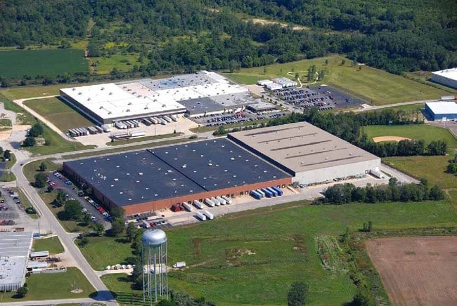
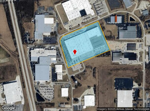
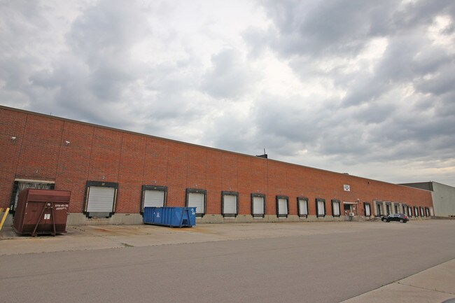
Property Record
1515 Riverfork Dr, Huntington, IN 46750
NEARBY LISTINGS FOR SALE OR LEASE
Property Detail
1515 Riverfork Dr
35-05-21-300-414.600-005
014-04146-00 E PT SUSAN RESERVE 18.10 AC
Warehouse
Huntington
X
Indiana
18069C0232D
18.10 AC
2024
Fort Wayne
2024
Other Market Areas
961900
Huntington, IN
411,066 SF
DEMOGRAPHICS near 1515 Riverfork Dr
1 Mile
3 Mile
5 Mile
2024 Total Population
1,168
18,258
24,176
2029 Population
1,174
18,491
24,427
Pop Growth 2024-2029
+ 0.51%
+ 1.28%
+ 1.04%
Average Age
43
39
40
2024 Total Households
463
7,398
9,770
HH Growth 2024-2029
+ 0.65%
+ 1.32%
+ 1.08%
Median Household Inc
$57,605
$50,188
$52,993
Avg Household Size
2.40
2.30
2.30
2024 Avg HH Vehicles
2.00
2.00
2.00
Median Home Value
$139,534
$92,774
$112,023
Median Year Built
1982
1953
1957
Nearby Places
Map Layers
Map Styles
 Street
 Aerial
- Restaurants
- Banks
- Shops
- Fitness
- Groceries
PUBLIC TRANSPORTATION
AIRPORT
Fort Wayne International
DRIVE
WALK
Distance
Fort Wayne International
37 min
24.0 mi
Freight Ports
Port of Toledo
DRIVE
WALK
Distance
Port of Toledo
171 min
135.0 mi
SALE & LEASE HISTORY
LISTING DATE
SALE/LEASE

Jun 26, 2018
For Lease
Jun 25, 2018
For Sale
Nearby Properties
Address
Land Use
TOTAL SIZE
Lot Size
Zoning
Address
Land Use
TOTAL SIZE
Lot Size
Zoning
187,224 SF
19.89 AC
Address
Land Use
TOTAL SIZE
Lot Size
Zoning
30.52 AC
Address
Land Use
TOTAL SIZE
Lot Size
Zoning
80,605 SF
9.11 AC
Address
Land Use
TOTAL SIZE
Lot Size
Zoning
210,310 SF
25.18 AC
Address
Land Use
TOTAL SIZE
Lot Size
Zoning
119,200 SF
2.17 AC
Address
Land Use
TOTAL SIZE
Lot Size
Zoning
270,008 SF
28.23 AC
Address
Land Use
TOTAL SIZE
Lot Size
Zoning
67,524 SF
12.03 AC
Address
Land Use
TOTAL SIZE
Lot Size
Zoning
316,816 SF
17.09 AC
Address
Land Use
TOTAL SIZE
Lot Size
Zoning
59,480 SF
15 AC
Address
Land Use
TOTAL SIZE
Lot Size
Zoning
43,916 SF
0.36 AC
Address
Land Use
TOTAL SIZE
Lot Size
Zoning
42,036 SF
0.15 AC
Address
Land Use
TOTAL SIZE
Lot Size
Zoning
72,000 SF
11.39 AC
Address
Land Use
TOTAL SIZE
Lot Size
Zoning
225,560 SF
13.32 AC
Address
Land Use
TOTAL SIZE
Lot Size
Zoning
22,180 SF
24.28 AC
Address
Land Use
TOTAL SIZE
Lot Size
Zoning
154,920 SF
3.45 AC
Address
Land Use
TOTAL SIZE
Lot Size
Zoning
57,829 SF
0.72 AC
Address
Land Use
TOTAL SIZE
Lot Size
Zoning
25,284 SF
10 AC
Address
Land Use
TOTAL SIZE
Lot Size
Zoning
10,770 SF
8.82 AC
Address
Land Use
TOTAL SIZE
Lot Size
Zoning
67,926 SF
0.91 AC
Address
Land Use
TOTAL SIZE
Lot Size
Zoning
48,175 SF
14.21 AC
Address
Land Use
TOTAL SIZE
Lot Size
Zoning
62,479 SF
29.61 AC
Address
Land Use
TOTAL SIZE
Lot Size
Zoning
27,744 SF
2.40 AC
Address
Land Use
TOTAL SIZE
Lot Size
Zoning
8,360 SF
23.54 AC
Address
Land Use
TOTAL SIZE
Lot Size
Zoning
154,808 SF
31.70 AC
Address
Land Use
TOTAL SIZE
Lot Size
Zoning
2,400 SF
14.25 AC
Address
Land Use
TOTAL SIZE
Lot Size
Zoning
45,429 SF
12.20 AC
Address
Land Use
TOTAL SIZE
Lot Size
Zoning
67,308 SF
6.22 AC
Address
Land Use
TOTAL SIZE
Lot Size
Zoning
38,670 SF
0.96 AC
Address
Land Use
TOTAL SIZE
Lot Size
Zoning
32,492 SF
2.87 AC
The World's #1 Commercial Real Estate Marketplace
Connect with us
© 2026 CoStar Group
The information above has been obtained from sources believed reliable. While we do not doubt its accuracy we have not verified it and make no guarantee, warranty or representation about it. It is your responsibility to independently confirm its accuracy and completeness. Any projections, opinions, assumptions, or estimates used are for example only and do not represent the current or future performance of the property. The value of this transaction to you depends on tax and other factors which should be evaluated by your tax, financial, and legal advisors. You and your advisors should conduct a careful, independent investigation of the property to determine to your satisfaction the suitability of the property for your needs.