Property Record
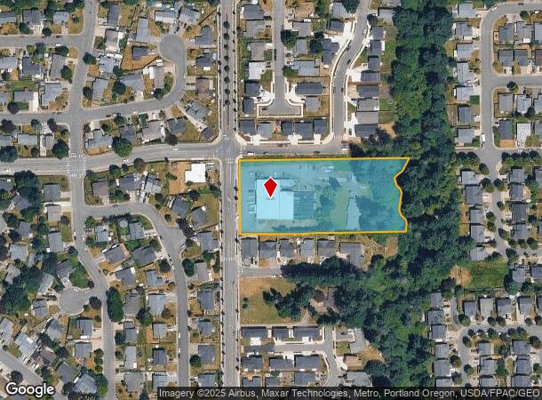
1515 S Parkway Ave, Battle Ground, WA 98604

NEARBY LISTINGS FOR SALE OR LEASE
Property Detail
1515 S Parkway Ave
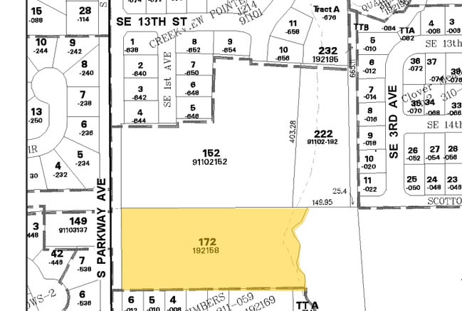
192158-000
#172 SEC 2 T3N R2EWM 2.73A FOR ASSESSOR USE ONLY BEG AT NW COR OF SW1/4 OF SW1/4 OF SEC 2 TH S ALG W LI OF SD SEC 2 220 FT TH E PLLWI N LI OF SW1/4 OF SW1/4 OF SD SEC 490 FT M/L TO CNTR OF WEAVER CRK TH NLY FOLL THREAD OF SD CRK TO N LI OF SW1/4 OF S
Stripcommercialcenter
Clark
AE
Washington
53011C0243D
2.73 AC
2025
Orchards
2025
Portland
040407
Portland-Vancouver-Hillsboro, OR-WA
9,930 SF
DEMOGRAPHICS near 1515 S Parkway Ave
1 Mile
3 Mile
5 Mile
2024 Total Population
8,031
31,356
54,850
2029 Population
8,668
33,905
59,248
Pop Growth 2024-2029
+ 7.93%
+ 8.13%
+ 8.02%
Average Age
38
39
39
2024 Total Households
3,005
10,672
18,590
HH Growth 2024-2029
+ 8.12%
+ 8.27%
+ 8.14%
Median Household Inc
$82,673
$96,020
$99,079
Avg Household Size
2.70
2.90
2.90
2024 Avg HH Vehicles
2.00
2.00
2.00
Median Home Value
$386,563
$460,661
$508,910
Median Year Built
1997
1997
1997
Nearby Places
Map Layers
Map Styles
 Street
 Aerial
- Restaurants
- Banks
- Shops
- Fitness
- Groceries
PUBLIC TRANSPORTATION
AIRPORT
Portland International
DRIVE
WALK
Distance
Portland International
30 min
17.8 mi
Freight Ports
Port of Vancouver
DRIVE
WALK
Distance
Port of Vancouver
28 min
16.3 mi
Nearby Properties
Address
Land Use
TOTAL SIZE
Lot Size
Zoning
Address
Land Use
TOTAL SIZE
Lot Size
Zoning
128,139 SF
37.02 AC
AG-20
Address
Land Use
TOTAL SIZE
Lot Size
Zoning
146,585 SF
41.85 AC
CC
Address
Land Use
TOTAL SIZE
Lot Size
Zoning
157,245 SF
39 AC
R-5
Address
Land Use
TOTAL SIZE
Lot Size
Zoning
196,625 SF
2.05 AC
MU-R
Address
Land Use
TOTAL SIZE
Lot Size
Zoning
166,003 SF
15.45 AC
RC
Address
Land Use
TOTAL SIZE
Lot Size
Zoning
114,689 SF
19.39 AC
RC
Address
Land Use
TOTAL SIZE
Lot Size
Zoning
129,044 SF
18.81 AC
R7
Address
Land Use
TOTAL SIZE
Lot Size
Zoning
204,121 SF
7.73 AC
MU-R
Address
Land Use
TOTAL SIZE
Lot Size
Zoning
150,874 SF
15.65 AC
RC
Address
Land Use
TOTAL SIZE
Lot Size
Zoning
84,614 SF
10 AC
RC
Address
Land Use
TOTAL SIZE
Lot Size
Zoning
47,476 SF
4.15 AC
RC
Address
Land Use
TOTAL SIZE
Lot Size
Zoning
74,390 SF
6.54 AC
ML
Address
Land Use
TOTAL SIZE
Lot Size
Zoning
136,286 SF
5 AC
RC
Address
Land Use
TOTAL SIZE
Lot Size
Zoning
69,785 SF
4.32 AC
RC
Address
Land Use
TOTAL SIZE
Lot Size
Zoning
57,924 SF
2.14 AC
D
Address
Land Use
TOTAL SIZE
Lot Size
Zoning
42,162 SF
4.28 AC
RC
Address
Land Use
TOTAL SIZE
Lot Size
Zoning
39,320 SF
8.59 AC
RC
Address
Land Use
TOTAL SIZE
Lot Size
Zoning
47,463 SF
1.78 AC
D
Address
Land Use
TOTAL SIZE
Lot Size
Zoning
31,118 SF
1.27 AC
D
Address
Land Use
TOTAL SIZE
Lot Size
Zoning
65,820 SF
2.09 AC
R7
Address
Land Use
TOTAL SIZE
Lot Size
Zoning
57,495 SF
1.47 AC
D
Address
Land Use
TOTAL SIZE
Lot Size
Zoning
55,480 SF
3.54 AC
R20
Address
Land Use
TOTAL SIZE
Lot Size
Zoning
76,626 SF
4.69 AC
RC-1
Address
Land Use
TOTAL SIZE
Lot Size
Zoning
60,996 SF
1.83 AC
R10
Address
Land Use
TOTAL SIZE
Lot Size
Zoning
30,514 SF
8.50 AC
RC-1
Address
Land Use
TOTAL SIZE
Lot Size
Zoning
38,344 SF
5 AC
AG-20
Address
Land Use
TOTAL SIZE
Lot Size
Zoning
48,930 SF
3.16 AC
R10
Address
Land Use
TOTAL SIZE
Lot Size
Zoning
46,060 SF
2.43 AC
R20
The World's #1 Commercial Real Estate Marketplace
Connect with us
© 2025 CoStar Group
The information above has been obtained from sources believed reliable. While we do not doubt its accuracy we have not verified it and make no guarantee, warranty or representation about it. It is your responsibility to independently confirm its accuracy and completeness. Any projections, opinions, assumptions, or estimates used are for example only and do not represent the current or future performance of the property. The value of this transaction to you depends on tax and other factors which should be evaluated by your tax, financial, and legal advisors. You and your advisors should conduct a careful, independent investigation of the property to determine to your satisfaction the suitability of the property for your needs.