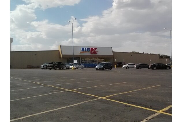
Property Record
1515 W 3Rd St, Alliance, NE 69301

NEARBY LISTINGS FOR SALE OR LEASE
-
-
View all Alliance listings for sale on LoopNet.com
Property Detail
1515 W 3Rd St
Other Market Areas
Syndicate Add
070208506
BLK 7A SYNDICATE ADD
Storebuilding
Box Butte
2024
Nebraska
2025
6.86 AC
951300
Nebraska Area
42,526 SF
DEMOGRAPHICS near 1515 W 3Rd St
1 Mile
3 Mile
5 Mile
2024 Total Population
1,606
8,672
8,808
2029 Population
1,613
8,577
8,707
Pop Growth 2024-2029
+ 0.44%
(1.10%)
(1.15%)
Average Age
39
41
41
2024 Total Households
651
3,669
3,727
HH Growth 2024-2029
+ 0.46%
(1.12%)
(1.15%)
Median Household Inc
$52,734
$64,044
$64,251
Avg Household Size
2.30
2.30
2.30
2024 Avg HH Vehicles
2.00
2.00
2.00
Median Home Value
$90,233
$147,805
$148,511
Median Year Built
1970
1969
1969
Nearby Places
Map Layers
Map Styles
 Street
 Aerial
- Restaurants
- Banks
- Shops
- Fitness
- Groceries
SALE & LEASE HISTORY
LISTING DATE
SALE/LEASE

Mar 07, 2018
For Sale
Feb 26, 2019
For Sale
Feb 01, 2021
For Sale
Nearby Properties
Address
Land Use
TOTAL SIZE
Lot Size
Zoning
Address
Land Use
TOTAL SIZE
Lot Size
Zoning
253,029 SF
107.40 AC
04-INDUSTR
Address
Land Use
TOTAL SIZE
Lot Size
Zoning
130,480 SF
16.53 AC
03-COMMERC
Address
Land Use
TOTAL SIZE
Lot Size
Zoning
125,084 SF
7.58 AC
01-SINGLE
Address
Land Use
TOTAL SIZE
Lot Size
Zoning
146,150 SF
12.20 AC
04-INDUSTR
Address
Land Use
TOTAL SIZE
Lot Size
Zoning
64,880 SF
1.89 AC
03-COMMERC
Address
Land Use
TOTAL SIZE
Lot Size
Zoning
37,115 SF
29.51 AC
04-INDUSTR
Address
Land Use
TOTAL SIZE
Lot Size
Zoning
60,000 SF
2.96 AC
01-SINGLE
Address
Land Use
TOTAL SIZE
Lot Size
Zoning
54.88 AC
03-COMMERC
Address
Land Use
TOTAL SIZE
Lot Size
Zoning
53,065 SF
10.59 AC
03-COMMERC
Address
Land Use
TOTAL SIZE
Lot Size
Zoning
43,200 SF
1.78 AC
03-COMMERC
Address
Land Use
TOTAL SIZE
Lot Size
Zoning
18,500 SF
15.56 AC
03-COMMERC
Address
Land Use
TOTAL SIZE
Lot Size
Zoning
1,624 SF
164 AC
03-COMMERC
Address
Land Use
TOTAL SIZE
Lot Size
Zoning
12,672 SF
23.98 AC
04-INDUSTR
Address
Land Use
TOTAL SIZE
Lot Size
Zoning
11,760 SF
14.50 AC
03-COMMERC
Address
Land Use
TOTAL SIZE
Lot Size
Zoning
15,008 SF
3.10 AC
01-SINGLE
Address
Land Use
TOTAL SIZE
Lot Size
Zoning
36,500 SF
5.46 AC
03-COMMERC
Address
Land Use
TOTAL SIZE
Lot Size
Zoning
1,189 SF
10.11 AC
03-COMMERC
Address
Land Use
TOTAL SIZE
Lot Size
Zoning
33,318 SF
4.35 AC
03-COMMERC
Address
Land Use
TOTAL SIZE
Lot Size
Zoning
20,646 SF
2.07 AC
01-SINGLE
Address
Land Use
TOTAL SIZE
Lot Size
Zoning
24,084 SF
13.21 AC
05-AGRICUL
Address
Land Use
TOTAL SIZE
Lot Size
Zoning
100 SF
11.91 AC
01-SINGLE
Address
Land Use
TOTAL SIZE
Lot Size
Zoning
88,794 SF
2.07 AC
01-SINGLE
Address
Land Use
TOTAL SIZE
Lot Size
Zoning
4,800 SF
8.72 AC
02-MULTI-F
Address
Land Use
TOTAL SIZE
Lot Size
Zoning
24,898 SF
5.92 AC
02-MULTI-F
Address
Land Use
TOTAL SIZE
Lot Size
Zoning
9,528 SF
1.31 AC
01-SINGLE
Address
Land Use
TOTAL SIZE
Lot Size
Zoning
21,676 SF
0.96 AC
03-COMMERC
Address
Land Use
TOTAL SIZE
Lot Size
Zoning
669.67 AC
05-AGRICUL
Address
Land Use
TOTAL SIZE
Lot Size
Zoning
27,046 SF
10.96 AC
02-MULTI-F
The World's #1 Commercial Real Estate Marketplace
Connect with us
© 2025 CoStar Group
The information above has been obtained from sources believed reliable. While we do not doubt its accuracy we have not verified it and make no guarantee, warranty or representation about it. It is your responsibility to independently confirm its accuracy and completeness. Any projections, opinions, assumptions, or estimates used are for example only and do not represent the current or future performance of the property. The value of this transaction to you depends on tax and other factors which should be evaluated by your tax, financial, and legal advisors. You and your advisors should conduct a careful, independent investigation of the property to determine to your satisfaction the suitability of the property for your needs.