Property Record
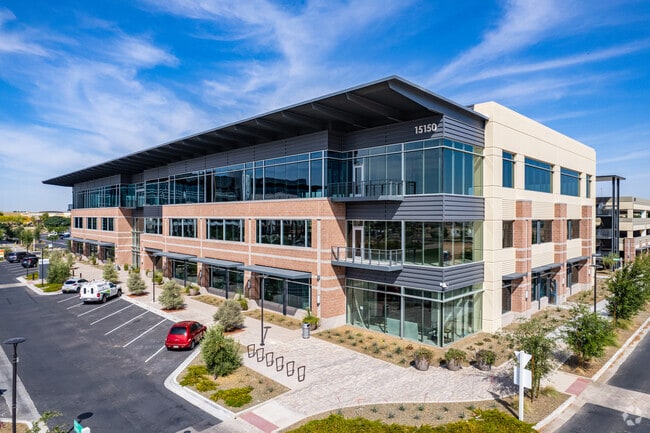
15150 W Park Pl, Goodyear, AZ 85395


Current Lease Availabilities
NEARBY LISTINGS FOR SALE OR LEASE
Property Detail
15150 W Park Pl
Phoenix-Mesa-Scottsdale, AZ
Goodyear Civic Square Parcel A At Estrel
501-73-972
GOODYEAR CIVIC SQUARE PARCEL A AT ESTRELLA FALLS MCR 1577-01
Officebuilding
Maricopa
X
Arizona
04013C2135L
6
2025
1.28 AC
2025
West I-10
061054
Phoenix
103,628 SF
DEMOGRAPHICS near 15150 W Park Pl
1 Mile
3 Mile
5 Mile
2024 Total Population
12,448
85,123
176,543
2029 Population
13,977
93,800
193,222
Pop Growth 2024-2029
+ 12.28%
+ 10.19%
+ 9.45%
Average Age
40
41
38
2024 Total Households
4,695
30,439
58,264
HH Growth 2024-2029
+ 12.18%
+ 10.38%
+ 9.63%
Median Household Inc
$91,353
$87,696
$87,293
Avg Household Size
2.60
2.70
2.90
2024 Avg HH Vehicles
2.00
2.00
2.00
Median Home Value
$440,509
$403,060
$374,861
Median Year Built
2010
2005
2004
Nearby Places
Map Layers
Map Styles
 Street
 Aerial
- Restaurants
- Banks
- Shops
- Fitness
- Groceries
PUBLIC TRANSPORTATION
AIRPORT
Phoenix Sky Harbor International
DRIVE
WALK
Distance
Phoenix Sky Harbor International
34 min
24.7 mi
Nearby Properties
Address
Land Use
TOTAL SIZE
Lot Size
Zoning
Address
Land Use
TOTAL SIZE
Lot Size
Zoning
16.70 AC
Address
Land Use
TOTAL SIZE
Lot Size
Zoning
76,301 SF
15.91 AC
Address
Land Use
TOTAL SIZE
Lot Size
Zoning
Address
Land Use
TOTAL SIZE
Lot Size
Zoning
49,475 SF
5.70 AC
PAD
Address
Land Use
TOTAL SIZE
Lot Size
Zoning
370,726 SF
23.41 AC
PAD
Address
Land Use
TOTAL SIZE
Lot Size
Zoning
324,374 SF
18.26 AC
PAD
Address
Land Use
TOTAL SIZE
Lot Size
Zoning
2.51 AC
Address
Land Use
TOTAL SIZE
Lot Size
Zoning
563,328 SF
24.43 AC
C2
Address
Land Use
TOTAL SIZE
Lot Size
Zoning
401,714 SF
100.01 AC
PAD
Address
Land Use
TOTAL SIZE
Lot Size
Zoning
802,439 SF
56.30 AC
PAD
Address
Land Use
TOTAL SIZE
Lot Size
Zoning
901,699 SF
49.92 AC
I1
Address
Land Use
TOTAL SIZE
Lot Size
Zoning
220,494 SF
50.53 AC
AG
Address
Land Use
TOTAL SIZE
Lot Size
Zoning
855,336 SF
45.11 AC
Address
Land Use
TOTAL SIZE
Lot Size
Zoning
802,671 SF
48.81 AC
I1
Address
Land Use
TOTAL SIZE
Lot Size
Zoning
320,888 SF
31.41 AC
C-G
Address
Land Use
TOTAL SIZE
Lot Size
Zoning
398,872 SF
9.39 AC
PAD
Address
Land Use
TOTAL SIZE
Lot Size
Zoning
601,124 SF
39.88 AC
PAD
Address
Land Use
TOTAL SIZE
Lot Size
Zoning
790,980 SF
42.95 AC
I1
Address
Land Use
TOTAL SIZE
Lot Size
Zoning
643,798 SF
42.24 AC
PAD
Address
Land Use
TOTAL SIZE
Lot Size
Zoning
643,756 SF
39.25 AC
PAD
Address
Land Use
TOTAL SIZE
Lot Size
Zoning
295,014 SF
37.63 AC
PAD
Address
Land Use
TOTAL SIZE
Lot Size
Zoning
222,900 SF
15.99 AC
Address
Land Use
TOTAL SIZE
Lot Size
Zoning
643,798 SF
39.40 AC
PAD
Address
Land Use
TOTAL SIZE
Lot Size
Zoning
355,597 SF
14.83 AC
PAD
Address
Land Use
TOTAL SIZE
Lot Size
Zoning
337,781 SF
9.11 AC
PF
Address
Land Use
TOTAL SIZE
Lot Size
Zoning
295,635 SF
16.57 AC
PAD
Address
Land Use
TOTAL SIZE
Lot Size
Zoning
293,849 SF
33.20 AC
PAD
Address
Land Use
TOTAL SIZE
Lot Size
Zoning
392,000 SF
26.57 AC
PAD
Address
Land Use
TOTAL SIZE
Lot Size
Zoning
663,150 SF
34.49 AC
Address
Land Use
TOTAL SIZE
Lot Size
Zoning
54,562 SF
7.65 AC
PAD
The World's #1 Commercial Real Estate Marketplace
Connect with us
© 2025 CoStar Group
The information above has been obtained from sources believed reliable. While we do not doubt its accuracy we have not verified it and make no guarantee, warranty or representation about it. It is your responsibility to independently confirm its accuracy and completeness. Any projections, opinions, assumptions, or estimates used are for example only and do not represent the current or future performance of the property. The value of this transaction to you depends on tax and other factors which should be evaluated by your tax, financial, and legal advisors. You and your advisors should conduct a careful, independent investigation of the property to determine to your satisfaction the suitability of the property for your needs.