Property Record
15153 B Hwy, Darrow, LA 70725

Save to a Folder
{{folder.Name}}
{{folder.ListingIds.length}} Properties
{{folder.ListingIds.length}} Property
Create a New Folder
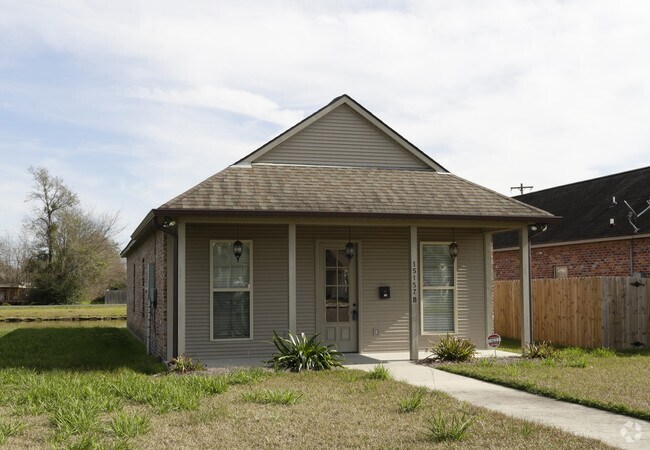
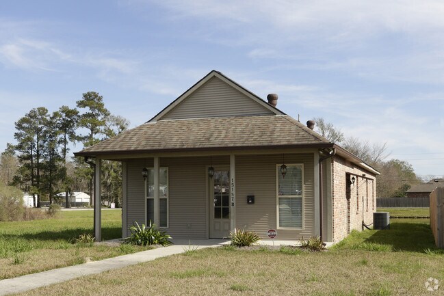
Property Detail
15153 B Hwy
Baton Rouge
.79 AC. SEC. 5-9-3, B-2-A-1-A-1-A (FKA UNIT B OF SAGEFIELD, A COMMERCIAL CONDOMINIUM DEVELOPMENT)
Baton Rouge, LA
ASCENSION
20034-723
Louisiana
Officebuilding
b2a1
2025
0.79 AC
2025
Ascension Parish
030214
NEARBY LISTINGS FOR SALE OR LEASE
DEMOGRAPHICS near 15153 B Hwy
1 mile
3 mile
5 mile
2025 Total Population
5,804
42,544
90,942
2030 Population
6,065
44,374
94,940
Pop Growth 2025-2030
+ 4.50%
+ 4.30%
+ 4.40%
Average Age
37
37
38
2025 Total Households
2,119
15,280
32,534
HH Growth 2025-2030
+ 4.53%
+ 4.33%
+ 4.41%
Median Household Inc
$105,330
$91,498
$89,594
Avg Household Size
2.70
2.70
2.70
2025 Avg HH Vehicles
2.00
2.00
2.00
Median Home Value
$279,159
$269,324
$283,593
Median Year Built
2003
2003
2002
Nearby Places
Map Layers
Map Styles
 Street
 Aerial
Layers
 Traffic
 Biking
Places
Listings with unknown addresses are not visible on the map
- Restaurants
- Banks
- Shops
- Fitness
- Groceries
PUBLIC TRANSPORTATION
AIRPORT
Baton Rouge Metro Ryan Field
Drive
Walk
Distance
Baton Rouge Metro Ryan Field
36 min
23.9 mi
Freight Ports
Port of Greater Baton Rouge
Drive
Walk
Distance
Port of Greater Baton Rouge
35 min
25.0 mi
Nearby Properties
Address
Land Use
TOTAL SIZE
Lot Size
Zoning
Address
Land Use
TOTAL SIZE
Lot Size
Zoning
59.40 AC
RM
Address
Land Use
TOTAL SIZE
Lot Size
Zoning
Address
Land Use
TOTAL SIZE
Lot Size
Zoning
17.88 AC
Address
Land Use
TOTAL SIZE
Lot Size
Zoning
Address
Land Use
TOTAL SIZE
Lot Size
Zoning
20 AC
RM
Address
Land Use
TOTAL SIZE
Lot Size
Zoning
19.93 AC
RM
Address
Land Use
TOTAL SIZE
Lot Size
Zoning
23.87 AC
RM
Address
Land Use
TOTAL SIZE
Lot Size
Zoning
34.85 AC
MU
Address
Land Use
TOTAL SIZE
Lot Size
Zoning
9.91 AC
MU
Address
Land Use
TOTAL SIZE
Lot Size
Zoning
13 AC
MU
Address
Land Use
TOTAL SIZE
Lot Size
Zoning
16.18 AC
RM
Address
Land Use
TOTAL SIZE
Lot Size
Zoning
30.44 AC
RM
Address
Land Use
TOTAL SIZE
Lot Size
Zoning
5.41 AC
MU
Address
Land Use
TOTAL SIZE
Lot Size
Zoning
6.72 AC
MU
Address
Land Use
TOTAL SIZE
Lot Size
Zoning
11.59 AC
Address
Land Use
TOTAL SIZE
Lot Size
Zoning
6.03 AC
CC
Address
Land Use
TOTAL SIZE
Lot Size
Zoning
Address
Land Use
TOTAL SIZE
Lot Size
Zoning
1.38 AC
MU2
Address
Land Use
TOTAL SIZE
Lot Size
Zoning
7.17 AC
RM
Address
Land Use
TOTAL SIZE
Lot Size
Zoning
2.59 AC
MU2
Address
Land Use
TOTAL SIZE
Lot Size
Zoning
2.76 AC
MU
Address
Land Use
TOTAL SIZE
Lot Size
Zoning
2.57 AC
MU
Address
Land Use
TOTAL SIZE
Lot Size
Zoning
5.14 AC
MU
Address
Land Use
TOTAL SIZE
Lot Size
Zoning
2.81 AC
RM
Address
Land Use
TOTAL SIZE
Lot Size
Zoning
5.81 AC
MU
Address
Land Use
TOTAL SIZE
Lot Size
Zoning
6.65 AC
MU
Address
Land Use
TOTAL SIZE
Lot Size
Zoning
1.03 AC
Address
Land Use
TOTAL SIZE
Lot Size
Zoning
7.42 AC
MU
Address
Land Use
TOTAL SIZE
Lot Size
Zoning
10.72 AC
MU
The World's #1 Commercial Real Estate Marketplace
Connect with us
© 2026 CoStar Group
The information above has been obtained from sources believed reliable. While we do not doubt its accuracy we have not verified it and make no guarantee, warranty or representation about it. It is your responsibility to independently confirm its accuracy and completeness. Any projections, opinions, assumptions, or estimates used are for example only and do not represent the current or future performance of the property. The value of this transaction to you depends on tax and other factors which should be evaluated by your tax, financial, and legal advisors. You and your advisors should conduct a careful, independent investigation of the property to determine to your satisfaction the suitability of the property for your needs.