Property Record
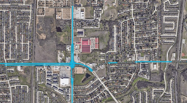
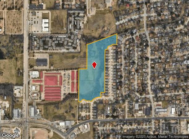
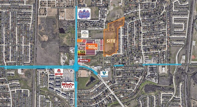
1516 Sycamore School Rd, Fort Worth, TX 76134
This Property Is For Sale
NEARBY LISTINGS FOR SALE OR LEASE
Property Detail
1516 Sycamore School Rd
Dallas-Fort Worth-Arlington, TX
Herrera, Gonefacio Survey
07543999
HERRERA, GONEFACIO SURVEY ABSTRACT 2027 TRACT 3G
Residentialacreage
Tarrant
AE
Texas
48439C0315L
14.35 AC
0
West Southwest Ft Worth
2025
Dallas/Ft Worth
106006
DEMOGRAPHICS near 1516 Sycamore School Rd
1 Mile
3 Mile
5 Mile
2024 Total Population
19,383
101,105
265,897
2029 Population
20,410
106,383
280,491
Pop Growth 2024-2029
+ 5.30%
+ 5.22%
+ 5.49%
Average Age
35
36
36
2024 Total Households
6,305
33,293
88,577
HH Growth 2024-2029
+ 5.23%
+ 5.18%
+ 5.56%
Median Household Inc
$55,536
$62,593
$62,255
Avg Household Size
3.00
3.00
2.90
2024 Avg HH Vehicles
2.00
2.00
2.00
Median Home Value
$191,289
$194,231
$217,381
Median Year Built
1988
1983
1983
Nearby Places
- Restaurants
- Banks
- Shops
- Fitness
- Groceries
PUBLIC TRANSPORTATION
COMMUTER RAIL
Fort Worth (Heartland Flyer - Amtrak, Texas Eagle - Amtrak)
DRIVE
WALK
Distance
Fort Worth (Heartland Flyer - Amtrak, Texas Eagle - Amtrak)
14 min
9.8 mi
Texas And Pacific (T&P) (Trinity Railway Express - Dallas Area Rapid Transit (DART))
DRIVE
WALK
Distance
Texas And Pacific (T&P) (Trinity Railway Express - Dallas Area Rapid Transit (DART))
16 min
9.9 mi
AIRPORT
Dallas-Fort Worth International
DRIVE
WALK
Distance
Dallas-Fort Worth International
45 min
33.9 mi
Freight Ports
Port of Shreveport
DRIVE
WALK
Distance
Port of Shreveport
249 min
230.0 mi
Nearby Properties
Address
Land Use
TOTAL SIZE
Lot Size
Zoning
Address
Land Use
TOTAL SIZE
Lot Size
Zoning
1,623,188 SF
84.13 AC
Address
Land Use
TOTAL SIZE
Lot Size
Zoning
555,914 SF
31.06 AC
Address
Land Use
TOTAL SIZE
Lot Size
Zoning
1,052,516 SF
102.74 AC
Address
Land Use
TOTAL SIZE
Lot Size
Zoning
1,129,204 SF
74.34 AC
Address
Land Use
TOTAL SIZE
Lot Size
Zoning
1,402,986 SF
68.89 AC
Address
Land Use
TOTAL SIZE
Lot Size
Zoning
781,200 SF
37.80 AC
Address
Land Use
TOTAL SIZE
Lot Size
Zoning
1,126,017 SF
76.27 AC
Address
Land Use
TOTAL SIZE
Lot Size
Zoning
655,500 SF
38.98 AC
Address
Land Use
TOTAL SIZE
Lot Size
Zoning
660,000 SF
33.91 AC
Address
Land Use
TOTAL SIZE
Lot Size
Zoning
647,228 SF
31.47 AC
Address
Land Use
TOTAL SIZE
Lot Size
Zoning
615,250 SF
32.43 AC
Address
Land Use
TOTAL SIZE
Lot Size
Zoning
344,170 SF
21.92 AC
Address
Land Use
TOTAL SIZE
Lot Size
Zoning
319,017 SF
14.68 AC
Address
Land Use
TOTAL SIZE
Lot Size
Zoning
655,500 SF
35.45 AC
Address
Land Use
TOTAL SIZE
Lot Size
Zoning
193,098 SF
25 AC
Address
Land Use
TOTAL SIZE
Lot Size
Zoning
462,777 SF
37.49 AC
Address
Land Use
TOTAL SIZE
Lot Size
Zoning
266,514 SF
14.06 AC
Address
Land Use
TOTAL SIZE
Lot Size
Zoning
615,054 SF
27.49 AC
Address
Land Use
TOTAL SIZE
Lot Size
Zoning
489,679 SF
27.08 AC
Address
Land Use
TOTAL SIZE
Lot Size
Zoning
488,564 SF
29.43 AC
Address
Land Use
TOTAL SIZE
Lot Size
Zoning
455,000 SF
6 AC
Address
Land Use
TOTAL SIZE
Lot Size
Zoning
147,466 SF
19.19 AC
Address
Land Use
TOTAL SIZE
Lot Size
Zoning
619,649 SF
53.64 AC
Address
Land Use
TOTAL SIZE
Lot Size
Zoning
585,000 SF
28.75 AC
Address
Land Use
TOTAL SIZE
Lot Size
Zoning
456,500 SF
29.55 AC
Address
Land Use
TOTAL SIZE
Lot Size
Zoning
865,460 SF
41.14 AC
Address
Land Use
TOTAL SIZE
Lot Size
Zoning
391,540 SF
21.17 AC
Address
Land Use
TOTAL SIZE
Lot Size
Zoning
230,452 SF
63.63 AC
Address
Land Use
TOTAL SIZE
Lot Size
Zoning
182,258 SF
9.33 AC
Address
Land Use
TOTAL SIZE
Lot Size
Zoning
765,351 SF
40.31 AC
The World's #1 Commercial Real Estate Marketplace
Connect with us
© 2025 CoStar Group
The information above has been obtained from sources believed reliable. While we do not doubt its accuracy we have not verified it and make no guarantee, warranty or representation about it. It is your responsibility to independently confirm its accuracy and completeness. Any projections, opinions, assumptions, or estimates used are for example only and do not represent the current or future performance of the property. The value of this transaction to you depends on tax and other factors which should be evaluated by your tax, financial, and legal advisors. You and your advisors should conduct a careful, independent investigation of the property to determine to your satisfaction the suitability of the property for your needs.