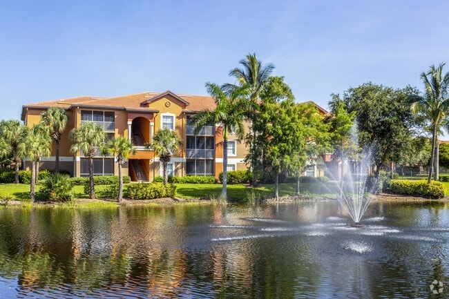
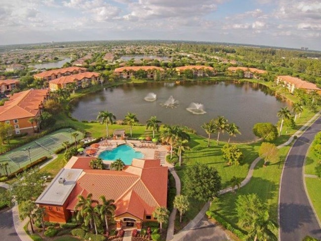
Property Record
15161 Sonoma Dr, Fort Myers, FL 33908


NEARBY LISTINGS FOR SALE OR LEASE
-
-
View all Fort Myers listings for sale on LoopNet.com
Property Detail
15161 Sonoma Dr
Cape Coral-Fort Myers, FL
Healthpark Florida
33-45-24-13-00000.0010
HEALTHPARK FLORIDA EAST PB 68 PGS 17-22 LOT 1
Multifamilydwelling
Lee
AE
Florida
12071C0419G
1
2024
33.53 AC
2025
Fort Myers Outlying
001918
Southwest Florida
313,369 SF
DEMOGRAPHICS near 15161 Sonoma Dr
1 Mile
3 Mile
5 Mile
2024 Total Population
8,366
56,147
121,633
2029 Population
9,898
67,053
144,771
Pop Growth 2024-2029
+ 18.31%
+ 19.42%
+ 19.02%
Average Age
51
55
52
2024 Total Households
3,716
27,939
59,813
HH Growth 2024-2029
+ 18.03%
+ 19.14%
+ 18.76%
Median Household Inc
$65,044
$62,736
$61,452
Avg Household Size
2.10
1.90
1.90
2024 Avg HH Vehicles
2.00
1.00
2.00
Median Home Value
$308,864
$267,769
$281,385
Median Year Built
2002
1995
1987
Nearby Places
Map Layers
Map Styles
 Street
 Aerial
- Restaurants
- Banks
- Shops
- Fitness
- Groceries
PUBLIC TRANSPORTATION
AIRPORT
Southwest Florida International
DRIVE
WALK
Distance
Southwest Florida International
24 min
13.2 mi
Punta Gorda
DRIVE
WALK
Distance
Punta Gorda
53 min
39.4 mi
Freight Ports
Port Manatee
DRIVE
WALK
Distance
Port Manatee
133 min
111.1 mi
Nearby Properties
Address
Land Use
TOTAL SIZE
Lot Size
Zoning
Address
Land Use
TOTAL SIZE
Lot Size
Zoning
1,116,051 SF
35.44 AC
CPD
Address
Land Use
TOTAL SIZE
Lot Size
Zoning
Address
Land Use
TOTAL SIZE
Lot Size
Zoning
539,207 SF
61.09 AC
AG-2
Address
Land Use
TOTAL SIZE
Lot Size
Zoning
562,104 SF
18.98 AC
RPD
Address
Land Use
TOTAL SIZE
Lot Size
Zoning
446,205 SF
28.90 AC
CC
Address
Land Use
TOTAL SIZE
Lot Size
Zoning
346,817 SF
26.28 AC
MPD
Address
Land Use
TOTAL SIZE
Lot Size
Zoning
423,044 SF
37.11 AC
C-1
Address
Land Use
TOTAL SIZE
Lot Size
Zoning
441,655 SF
33.09 AC
RM-2
Address
Land Use
TOTAL SIZE
Lot Size
Zoning
335,660 SF
15.42 AC
MPD
Address
Land Use
TOTAL SIZE
Lot Size
Zoning
209,483 SF
15.03 AC
CF-2
Address
Land Use
TOTAL SIZE
Lot Size
Zoning
261,136 SF
11.68 AC
AG-2
Address
Land Use
TOTAL SIZE
Lot Size
Zoning
9,670 SF
9.12 AC
AG-2
Address
Land Use
TOTAL SIZE
Lot Size
Zoning
153,907 SF
22.03 AC
TFC2
Address
Land Use
TOTAL SIZE
Lot Size
Zoning
96,448 SF
3.85 AC
CPD
Address
Land Use
TOTAL SIZE
Lot Size
Zoning
469,746 SF
89.45 AC
RPD
Address
Land Use
TOTAL SIZE
Lot Size
Zoning
65,051 SF
4.89 AC
CFPD
Address
Land Use
TOTAL SIZE
Lot Size
Zoning
301,212 SF
5.28 AC
Address
Land Use
TOTAL SIZE
Lot Size
Zoning
15.22 AC
CF-3
Address
Land Use
TOTAL SIZE
Lot Size
Zoning
123,050 SF
15.90 AC
CPD
Address
Land Use
TOTAL SIZE
Lot Size
Zoning
84,147 SF
10.60 AC
CPD
Address
Land Use
TOTAL SIZE
Lot Size
Zoning
89,321 SF
11.40 AC
CPD
Address
Land Use
TOTAL SIZE
Lot Size
Zoning
85,745 SF
10.22 AC
CPD
Address
Land Use
TOTAL SIZE
Lot Size
Zoning
228,715 SF
27.52 AC
CPD
Address
Land Use
TOTAL SIZE
Lot Size
Zoning
13.65 AC
CPD
Address
Land Use
TOTAL SIZE
Lot Size
Zoning
11.29 AC
CPD
Address
Land Use
TOTAL SIZE
Lot Size
Zoning
50,491 SF
10.54 AC
CG
Address
Land Use
TOTAL SIZE
Lot Size
Zoning
132,456 SF
7.86 AC
IPD
Address
Land Use
TOTAL SIZE
Lot Size
Zoning
38,928 SF
4.88 AC
CT
Address
Land Use
TOTAL SIZE
Lot Size
Zoning
85,275 SF
11.20 AC
C-1
The World's #1 Commercial Real Estate Marketplace
Connect with us
© 2025 CoStar Group
The information above has been obtained from sources believed reliable. While we do not doubt its accuracy we have not verified it and make no guarantee, warranty or representation about it. It is your responsibility to independently confirm its accuracy and completeness. Any projections, opinions, assumptions, or estimates used are for example only and do not represent the current or future performance of the property. The value of this transaction to you depends on tax and other factors which should be evaluated by your tax, financial, and legal advisors. You and your advisors should conduct a careful, independent investigation of the property to determine to your satisfaction the suitability of the property for your needs.