Property Record
1517 Forbes Ave, Pittsburgh, PA 15219
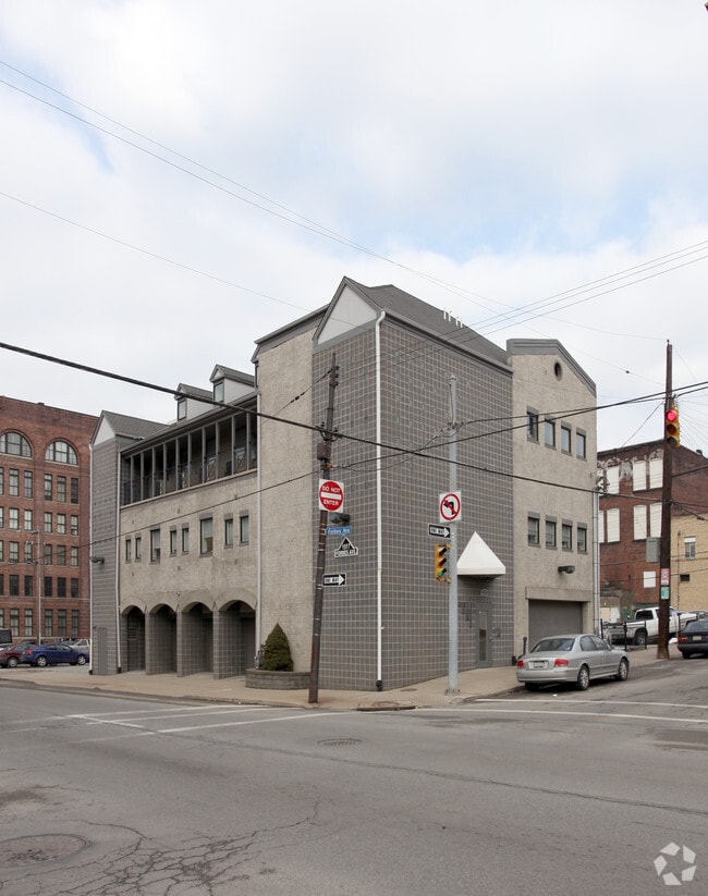

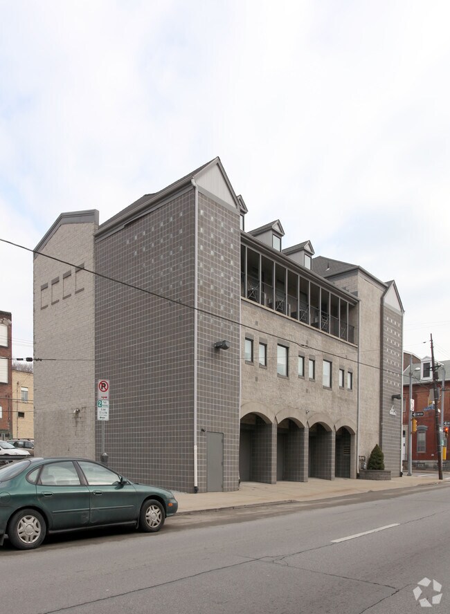
Property Detail
1517 Forbes Ave
Pittsburgh, PA
M PRIDE PLAN PTS 86-87 LOT 68X46.20 IN ALL FORB ES ST N W COR MARION ST 3 STY BRK OFF BLDG
0002-M-00188-0000-00
Allegheny
Medicalbuilding
Pennsylvania
B and X Area of moderate flood hazard, usually the area between the limits of the 100-year and 500-year floods.
188
2026
0.07 AC
2026
Greater Downtown
010302
Pittsburgh
NEARBY LISTINGS FOR SALE OR LEASE
DEMOGRAPHICS near 1517 Forbes Ave
1 mile
3 mile
5 mile
2025 Total Population
23,792
172,870
393,717
2030 Population
24,363
173,716
391,464
Pop Growth 2025-2030
+ 2.40%
+ 0.49%
(0.57%)
Average Age
35
37
39
2025 Total Households
10,573
79,241
181,485
HH Growth 2025-2030
+ 2.67%
+ 0.33%
(0.67%)
Median Household Inc
$59,199
$59,532
$67,261
Avg Household Size
1.70
1.90
2.00
2025 Avg HH Vehicles
1.00
1.00
1.00
Median Home Value
$279,903
$222,906
$217,362
Median Year Built
1963
1949
1949
Nearby Places
Map Layers
Map Styles
 Street
 Aerial
Layers
 Traffic
 Biking
Places
Listings with unknown addresses are not visible on the map
- Restaurants
- Banks
- Shops
- Fitness
- Groceries
PUBLIC TRANSPORTATION
TRANSIT/SUBWAY
Steel Plaza (42C Castle Shannon - Port Authority of Allegheny County Light Rail (The "T"), 42S South Hills Village - Port Authority of Allegheny County Light Rail (The "T"), 47L Library - Port Authority of Allegheny County Light Rail (The "T"), 47S South Hills Village - Port Authority of Allegheny County Light Rail (The "T"), 52 Allentown - Port Authority of Allegheny County Light Rail (The "T"))
Drive
Walk
Distance
Steel Plaza (42C Castle Shannon - Port Authority of Allegheny County Light Rail (The "T"), 42S South Hills Village - Port Authority of Allegheny County Light Rail (The "T"), 47L Library - Port Authority of Allegheny County Light Rail (The "T"), 47S South Hills Village - Port Authority of Allegheny County Light Rail (The "T"), 52 Allentown - Port Authority of Allegheny County Light Rail (The "T"))
2 min
15 min
0.8 mi
First Avenue (42C Castle Shannon - Port Authority of Allegheny County Light Rail (The "T"), 42S South Hills Village - Port Authority of Allegheny County Light Rail (The "T"), 47L Library - Port Authority of Allegheny County Light Rail (The "T"), 47S South Hills Village - Port Authority of Allegheny County Light Rail (The "T"), 52 Allentown - Port Authority of Allegheny County Light Rail (The "T"))
Drive
Walk
Distance
First Avenue (42C Castle Shannon - Port Authority of Allegheny County Light Rail (The "T"), 42S South Hills Village - Port Authority of Allegheny County Light Rail (The "T"), 47L Library - Port Authority of Allegheny County Light Rail (The "T"), 47S South Hills Village - Port Authority of Allegheny County Light Rail (The "T"), 52 Allentown - Port Authority of Allegheny County Light Rail (The "T"))
3 min
19 min
0.9 mi
Wood Street (42C Castle Shannon - Port Authority of Allegheny County Light Rail (The "T"), 42S South Hills Village - Port Authority of Allegheny County Light Rail (The "T"), 47L Library - Port Authority of Allegheny County Light Rail (The "T"), 47S South Hills Village - Port Authority of Allegheny County Light Rail (The "T"), 52 Allentown - Port Authority of Allegheny County Light Rail (The "T"))
Drive
Walk
Distance
Wood Street (42C Castle Shannon - Port Authority of Allegheny County Light Rail (The "T"), 42S South Hills Village - Port Authority of Allegheny County Light Rail (The "T"), 47L Library - Port Authority of Allegheny County Light Rail (The "T"), 47S South Hills Village - Port Authority of Allegheny County Light Rail (The "T"), 52 Allentown - Port Authority of Allegheny County Light Rail (The "T"))
3 min
20 min
1.0 mi
COMMUTER RAIL
Drive
Walk
Distance
3 min
20 min
1.0 mi
AIRPORT
Pittsburgh International
Drive
Walk
Distance
Pittsburgh International
30 min
18.0 mi
Arnold Palmer Regional
Drive
Walk
Distance
Arnold Palmer Regional
66 min
42.2 mi
Nearby Properties
Address
Land Use
TOTAL SIZE
Lot Size
Zoning
Address
Land Use
TOTAL SIZE
Lot Size
Zoning
10.41 AC
Address
Land Use
TOTAL SIZE
Lot Size
Zoning
Address
Land Use
TOTAL SIZE
Lot Size
Zoning
14.70 AC
Address
Land Use
TOTAL SIZE
Lot Size
Zoning
6.99 AC
Address
Land Use
TOTAL SIZE
Lot Size
Zoning
Address
Land Use
TOTAL SIZE
Lot Size
Zoning
3.86 AC
Address
Land Use
TOTAL SIZE
Lot Size
Zoning
13.75 AC
Address
Land Use
TOTAL SIZE
Lot Size
Zoning
10.14 AC
Address
Land Use
TOTAL SIZE
Lot Size
Zoning
31.36 AC
Address
Land Use
TOTAL SIZE
Lot Size
Zoning
13.53 AC
Address
Land Use
TOTAL SIZE
Lot Size
Zoning
3.35 AC
Address
Land Use
TOTAL SIZE
Lot Size
Zoning
5.11 AC
Address
Land Use
TOTAL SIZE
Lot Size
Zoning
10.55 AC
Address
Land Use
TOTAL SIZE
Lot Size
Zoning
2.68 AC
Address
Land Use
TOTAL SIZE
Lot Size
Zoning
13.85 AC
Address
Land Use
TOTAL SIZE
Lot Size
Zoning
19.39 AC
Address
Land Use
TOTAL SIZE
Lot Size
Zoning
10.22 AC
Address
Land Use
TOTAL SIZE
Lot Size
Zoning
5.77 AC
Address
Land Use
TOTAL SIZE
Lot Size
Zoning
4.05 AC
Address
Land Use
TOTAL SIZE
Lot Size
Zoning
3.91 AC
Address
Land Use
TOTAL SIZE
Lot Size
Zoning
12.80 AC
Address
Land Use
TOTAL SIZE
Lot Size
Zoning
0.92 AC
Address
Land Use
TOTAL SIZE
Lot Size
Zoning
3.78 AC
Address
Land Use
TOTAL SIZE
Lot Size
Zoning
2.46 AC
Address
Land Use
TOTAL SIZE
Lot Size
Zoning
8.97 AC
Address
Land Use
TOTAL SIZE
Lot Size
Zoning
2.67 AC
Address
Land Use
TOTAL SIZE
Lot Size
Zoning
2.52 AC
Address
Land Use
TOTAL SIZE
Lot Size
Zoning
Address
Land Use
TOTAL SIZE
Lot Size
Zoning
1.20 AC
Address
Land Use
TOTAL SIZE
Lot Size
Zoning
2.31 AC
The World's #1 Commercial Real Estate Marketplace
Connect with us
© 2026 CoStar Group
The information above has been obtained from sources believed reliable. While we do not doubt its accuracy we have not verified it and make no guarantee, warranty or representation about it. It is your responsibility to independently confirm its accuracy and completeness. Any projections, opinions, assumptions, or estimates used are for example only and do not represent the current or future performance of the property. The value of this transaction to you depends on tax and other factors which should be evaluated by your tax, financial, and legal advisors. You and your advisors should conduct a careful, independent investigation of the property to determine to your satisfaction the suitability of the property for your needs.