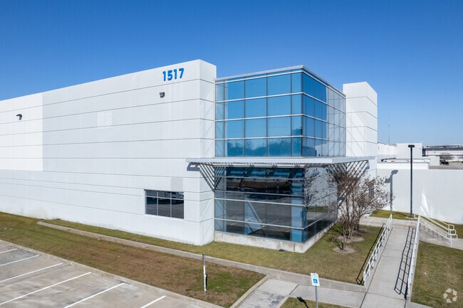
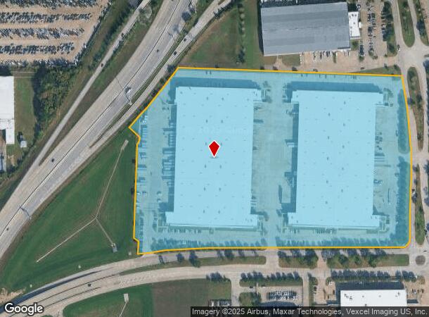
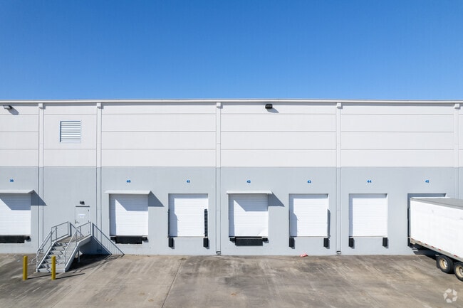
Property Record
1517 Greens Rd, Houston, TX 77032
Current Lease Availabilities
NEARBY LISTINGS FOR SALE OR LEASE
Property Detail
1517 Greens Rd
1299790010003
Central Nolen
Warehouse
RES A-2 BLK 1 CENTRAL NOLEN
AE
Harris
48201C0460M
Texas
2024
25.13 AC
2025
North Hardy Toll Road
240400
Houston
502,325 SF
Houston-Pasadena-The Woodlands, TX
DEMOGRAPHICS near 1517 Greens Rd
1 Mile
3 Mile
5 Mile
2024 Total Population
7,623
69,407
199,649
2029 Population
7,991
70,789
203,056
Pop Growth 2024-2029
+ 4.83%
+ 1.99%
+ 1.71%
Average Age
31
31
33
2024 Total Households
2,851
22,752
63,054
HH Growth 2024-2029
+ 5.09%
+ 2.13%
+ 1.83%
Median Household Inc
$37,253
$36,993
$39,404
Avg Household Size
2.60
3.00
3.10
2024 Avg HH Vehicles
1.00
2.00
2.00
Median Home Value
$93,897
$146,468
$148,756
Median Year Built
1987
1984
1986
Nearby Places
Map Layers
Map Styles
 Street
 Aerial
- Restaurants
- Banks
- Shops
- Fitness
- Groceries
PUBLIC TRANSPORTATION
AIRPORT
George Bush Intcntl/Houston
DRIVE
WALK
Distance
George Bush Intcntl/Houston
6 min
5.3 mi
William P Hobby
DRIVE
WALK
Distance
William P Hobby
44 min
27.5 mi
Freight Ports
Port of Houston
DRIVE
WALK
Distance
Port of Houston
32 min
21.4 mi
Nearby Properties
Address
Land Use
TOTAL SIZE
Lot Size
Zoning
Address
Land Use
TOTAL SIZE
Lot Size
Zoning
1,213,044 SF
69.99 AC
Address
Land Use
TOTAL SIZE
Lot Size
Zoning
1,767,053 SF
88.85 AC
Address
Land Use
TOTAL SIZE
Lot Size
Zoning
739,141 SF
54 AC
Address
Land Use
TOTAL SIZE
Lot Size
Zoning
621,700 SF
67.57 AC
Address
Land Use
TOTAL SIZE
Lot Size
Zoning
704,105 SF
40.72 AC
Address
Land Use
TOTAL SIZE
Lot Size
Zoning
657,500 SF
36.24 AC
Address
Land Use
TOTAL SIZE
Lot Size
Zoning
500,000 SF
24.58 AC
Address
Land Use
TOTAL SIZE
Lot Size
Zoning
485,125 SF
28.55 AC
Address
Land Use
TOTAL SIZE
Lot Size
Zoning
276,324 SF
33.79 AC
Address
Land Use
TOTAL SIZE
Lot Size
Zoning
368,632 SF
20.06 AC
Address
Land Use
TOTAL SIZE
Lot Size
Zoning
241,625 SF
11.10 AC
Address
Land Use
TOTAL SIZE
Lot Size
Zoning
394,784 SF
22.47 AC
Address
Land Use
TOTAL SIZE
Lot Size
Zoning
350,500 SF
17.71 AC
Address
Land Use
TOTAL SIZE
Lot Size
Zoning
353,600 SF
23.45 AC
Address
Land Use
TOTAL SIZE
Lot Size
Zoning
356,622 SF
18.26 AC
Address
Land Use
TOTAL SIZE
Lot Size
Zoning
448,760 SF
8.46 AC
Address
Land Use
TOTAL SIZE
Lot Size
Zoning
125,512 SF
18.26 AC
Address
Land Use
TOTAL SIZE
Lot Size
Zoning
423,730 SF
5.91 AC
Address
Land Use
TOTAL SIZE
Lot Size
Zoning
291,656 SF
18.94 AC
Address
Land Use
TOTAL SIZE
Lot Size
Zoning
435,650 SF
Address
Land Use
TOTAL SIZE
Lot Size
Zoning
329,643 SF
19.99 AC
Address
Land Use
TOTAL SIZE
Lot Size
Zoning
57,551 SF
49.71 AC
Address
Land Use
TOTAL SIZE
Lot Size
Zoning
318,000 SF
18.53 AC
Address
Land Use
TOTAL SIZE
Lot Size
Zoning
257,000 SF
13.34 AC
Address
Land Use
TOTAL SIZE
Lot Size
Zoning
288,525 SF
17.66 AC
Address
Land Use
TOTAL SIZE
Lot Size
Zoning
597,462 SF
42.07 AC
Address
Land Use
TOTAL SIZE
Lot Size
Zoning
227,400 SF
19.37 AC
Address
Land Use
TOTAL SIZE
Lot Size
Zoning
267,158 SF
12.96 AC
Address
Land Use
TOTAL SIZE
Lot Size
Zoning
383,451 SF
15.98 AC
The World's #1 Commercial Real Estate Marketplace
Connect with us
© 2026 CoStar Group
The information above has been obtained from sources believed reliable. While we do not doubt its accuracy we have not verified it and make no guarantee, warranty or representation about it. It is your responsibility to independently confirm its accuracy and completeness. Any projections, opinions, assumptions, or estimates used are for example only and do not represent the current or future performance of the property. The value of this transaction to you depends on tax and other factors which should be evaluated by your tax, financial, and legal advisors. You and your advisors should conduct a careful, independent investigation of the property to determine to your satisfaction the suitability of the property for your needs.