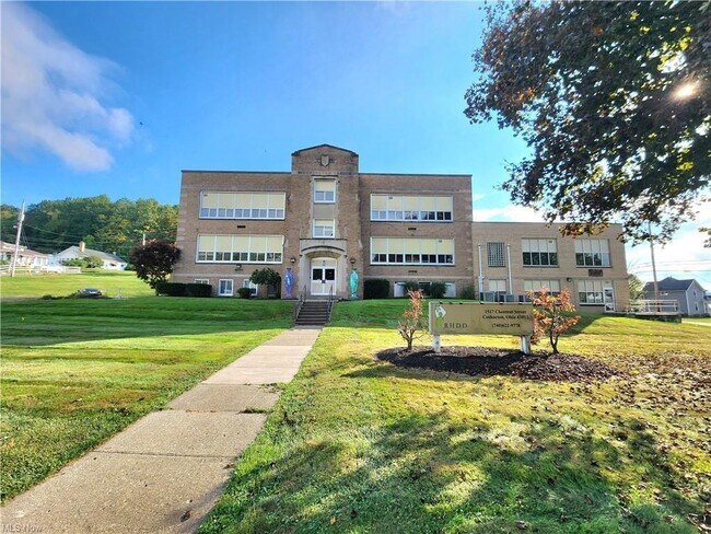
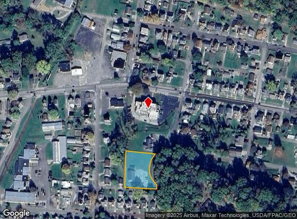
Property Record
1517 N Chestnut St, Coshocton, OH 43812
NEARBY LISTINGS FOR SALE OR LEASE
-
-
View all Coshocton listings for sale on LoopNet.com
Property Detail
1517 N Chestnut St
Coshocton, OH
Hall & Henderson Brothers Subdivis
04315-109-446-00
OL 177
Publicschool
Coshocton
X
Ohio
39031C0215C
0.83 AC
2024
Ohio North Area
2024
Other Market Areas
961700
DEMOGRAPHICS near 1517 N Chestnut St
1 Mile
3 Mile
5 Mile
2024 Total Population
6,794
14,427
19,040
2029 Population
6,786
14,458
19,074
Pop Growth 2024-2029
(0.12%)
+ 0.21%
+ 0.18%
Average Age
39
42
42
2024 Total Households
2,810
6,234
8,021
HH Growth 2024-2029
(0.18%)
+ 0.22%
+ 0.19%
Median Household Inc
$46,734
$42,294
$44,288
Avg Household Size
2.30
2.20
2.30
2024 Avg HH Vehicles
2.00
2.00
2.00
Median Home Value
$74,732
$92,581
$105,382
Median Year Built
1948
1955
1959
Nearby Places
Map Layers
Map Styles
 Street
 Aerial
- Restaurants
- Banks
- Shops
- Fitness
- Groceries
SALE & LEASE HISTORY
LISTING DATE
SALE/LEASE

May 03, 2024
For Sale
Nearby Properties
Address
Land Use
TOTAL SIZE
Lot Size
Zoning
Address
Land Use
TOTAL SIZE
Lot Size
Zoning
792 SF
26.21 AC
Address
Land Use
TOTAL SIZE
Lot Size
Zoning
3.25 AC
Address
Land Use
TOTAL SIZE
Lot Size
Zoning
1.21 AC
Address
Land Use
TOTAL SIZE
Lot Size
Zoning
183,906 SF
31.16 AC
Address
Land Use
TOTAL SIZE
Lot Size
Zoning
11,200 SF
20.80 AC
Address
Land Use
TOTAL SIZE
Lot Size
Zoning
20,990 SF
1.61 AC
Address
Land Use
TOTAL SIZE
Lot Size
Zoning
263,272 SF
30.62 AC
Address
Land Use
TOTAL SIZE
Lot Size
Zoning
9,703 SF
12 AC
Address
Land Use
TOTAL SIZE
Lot Size
Zoning
38.53 AC
Address
Land Use
TOTAL SIZE
Lot Size
Zoning
20.13 AC
Address
Land Use
TOTAL SIZE
Lot Size
Zoning
4,014 SF
34.92 AC
Address
Land Use
TOTAL SIZE
Lot Size
Zoning
48,185 SF
1.36 AC
Address
Land Use
TOTAL SIZE
Lot Size
Zoning
2,693 SF
37.51 AC
Address
Land Use
TOTAL SIZE
Lot Size
Zoning
3,055 SF
11.15 AC
Address
Land Use
TOTAL SIZE
Lot Size
Zoning
37.85 AC
Address
Land Use
TOTAL SIZE
Lot Size
Zoning
32,896 SF
0.15 AC
Address
Land Use
TOTAL SIZE
Lot Size
Zoning
38,997 SF
4.11 AC
Address
Land Use
TOTAL SIZE
Lot Size
Zoning
52,736 SF
17.14 AC
Address
Land Use
TOTAL SIZE
Lot Size
Zoning
74,740 SF
0.11 AC
Address
Land Use
TOTAL SIZE
Lot Size
Zoning
7,684 SF
2.76 AC
Address
Land Use
TOTAL SIZE
Lot Size
Zoning
Address
Land Use
TOTAL SIZE
Lot Size
Zoning
2,940 SF
3.56 AC
Address
Land Use
TOTAL SIZE
Lot Size
Zoning
7,872 SF
0.27 AC
Address
Land Use
TOTAL SIZE
Lot Size
Zoning
162,786 SF
9.17 AC
Address
Land Use
TOTAL SIZE
Lot Size
Zoning
33,952 SF
7.63 AC
Address
Land Use
TOTAL SIZE
Lot Size
Zoning
35,704 SF
45.78 AC
Address
Land Use
TOTAL SIZE
Lot Size
Zoning
30.62 AC
Address
Land Use
TOTAL SIZE
Lot Size
Zoning
69,604 SF
21.09 AC
Address
Land Use
TOTAL SIZE
Lot Size
Zoning
422.83 AC
Address
Land Use
TOTAL SIZE
Lot Size
Zoning
0.72 AC
The World's #1 Commercial Real Estate Marketplace
Connect with us
© 2025 CoStar Group
The information above has been obtained from sources believed reliable. While we do not doubt its accuracy we have not verified it and make no guarantee, warranty or representation about it. It is your responsibility to independently confirm its accuracy and completeness. Any projections, opinions, assumptions, or estimates used are for example only and do not represent the current or future performance of the property. The value of this transaction to you depends on tax and other factors which should be evaluated by your tax, financial, and legal advisors. You and your advisors should conduct a careful, independent investigation of the property to determine to your satisfaction the suitability of the property for your needs.