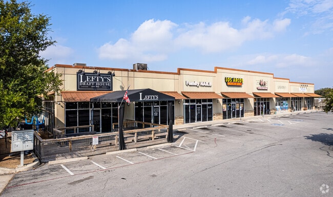
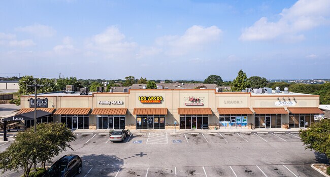
Property Record
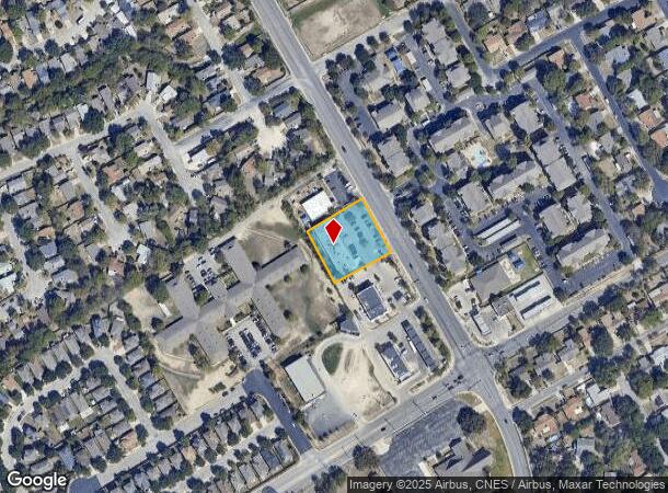
15179 Judson Rd, San Antonio, TX 78247
NEARBY LISTINGS FOR SALE OR LEASE
Property Detail
15179 Judson Rd
San Antonio-New Braunfels, TX
Conv A/S Code
17789-007-0010
NCB 17789 BLK 7 LOT 1 CROSSING JUDSON AMENDING PLAT 9569/66 & PLAT 9565/68
Regionalshoppingcenterormallwithanchorstore
Bexar
X
Texas
48029C0260G
1
2024
0.86 AC
2025
North Central
121808
San Antonio
9,900 SF
DEMOGRAPHICS near 15179 Judson Rd
1 Mile
3 Mile
5 Mile
2024 Total Population
15,242
79,639
200,349
2029 Population
16,005
84,286
213,149
Pop Growth 2024-2029
+ 5.01%
+ 5.84%
+ 6.39%
Average Age
39
38
38
2024 Total Households
5,472
29,310
76,949
HH Growth 2024-2029
+ 5.19%
+ 5.98%
+ 6.51%
Median Household Inc
$77,067
$72,002
$72,069
Avg Household Size
2.70
2.70
2.60
2024 Avg HH Vehicles
2.00
2.00
2.00
Median Home Value
$199,570
$196,276
$228,889
Median Year Built
1988
1990
1991
Nearby Places
Map Layers
Map Styles
 Street
 Aerial
- Restaurants
- Banks
- Shops
- Fitness
- Groceries
PUBLIC TRANSPORTATION
AIRPORT
San Antonio International
DRIVE
WALK
Distance
San Antonio International
17 min
8.6 mi
Freight Ports
Calhoun Port
DRIVE
WALK
Distance
Calhoun Port
181 min
150.3 mi
SALE & LEASE HISTORY
LISTING DATE
SALE/LEASE

May 28, 2021
For Lease
Nearby Properties
Address
Land Use
TOTAL SIZE
Lot Size
Zoning
Address
Land Use
TOTAL SIZE
Lot Size
Zoning
435,882 SF
27.85 AC
Address
Land Use
TOTAL SIZE
Lot Size
Zoning
37,195 SF
1,118.06 AC
Address
Land Use
TOTAL SIZE
Lot Size
Zoning
402,370 SF
45.49 AC
Address
Land Use
TOTAL SIZE
Lot Size
Zoning
523,268 SF
22.57 AC
Address
Land Use
TOTAL SIZE
Lot Size
Zoning
383,541 SF
12.41 AC
Address
Land Use
TOTAL SIZE
Lot Size
Zoning
298,710 SF
11.36 AC
Address
Land Use
TOTAL SIZE
Lot Size
Zoning
307,210 SF
14.26 AC
Address
Land Use
TOTAL SIZE
Lot Size
Zoning
350,805 SF
20.85 AC
Address
Land Use
TOTAL SIZE
Lot Size
Zoning
441,676 SF
19.99 AC
Address
Land Use
TOTAL SIZE
Lot Size
Zoning
345,622 SF
26.98 AC
Address
Land Use
TOTAL SIZE
Lot Size
Zoning
246,965 SF
11.73 AC
Address
Land Use
TOTAL SIZE
Lot Size
Zoning
280,516 SF
12.92 AC
Address
Land Use
TOTAL SIZE
Lot Size
Zoning
240,644 SF
16.35 AC
Address
Land Use
TOTAL SIZE
Lot Size
Zoning
199,756 SF
19.75 AC
Address
Land Use
TOTAL SIZE
Lot Size
Zoning
281,145 SF
29.26 AC
Address
Land Use
TOTAL SIZE
Lot Size
Zoning
251,110 SF
12.26 AC
Address
Land Use
TOTAL SIZE
Lot Size
Zoning
258,951 SF
15.43 AC
Address
Land Use
TOTAL SIZE
Lot Size
Zoning
256,497 SF
16.53 AC
Address
Land Use
TOTAL SIZE
Lot Size
Zoning
223,980 SF
17.11 AC
Address
Land Use
TOTAL SIZE
Lot Size
Zoning
490,283 SF
38.97 AC
Address
Land Use
TOTAL SIZE
Lot Size
Zoning
229,077 SF
10.06 AC
Address
Land Use
TOTAL SIZE
Lot Size
Zoning
212,072 SF
10.66 AC
Address
Land Use
TOTAL SIZE
Lot Size
Zoning
540,551 SF
21.09 AC
Address
Land Use
TOTAL SIZE
Lot Size
Zoning
180,000 SF
40.73 AC
Address
Land Use
TOTAL SIZE
Lot Size
Zoning
351,802 SF
43.07 AC
Address
Land Use
TOTAL SIZE
Lot Size
Zoning
284,788 SF
20.52 AC
Address
Land Use
TOTAL SIZE
Lot Size
Zoning
263,209 SF
13.67 AC
Address
Land Use
TOTAL SIZE
Lot Size
Zoning
65,271 SF
1,351.01 AC
Address
Land Use
TOTAL SIZE
Lot Size
Zoning
171,118 SF
14.14 AC
Address
Land Use
TOTAL SIZE
Lot Size
Zoning
228,927 SF
16.25 AC
The World's #1 Commercial Real Estate Marketplace
Connect with us
© 2025 CoStar Group
The information above has been obtained from sources believed reliable. While we do not doubt its accuracy we have not verified it and make no guarantee, warranty or representation about it. It is your responsibility to independently confirm its accuracy and completeness. Any projections, opinions, assumptions, or estimates used are for example only and do not represent the current or future performance of the property. The value of this transaction to you depends on tax and other factors which should be evaluated by your tax, financial, and legal advisors. You and your advisors should conduct a careful, independent investigation of the property to determine to your satisfaction the suitability of the property for your needs.